 It was not an easy task to retrace the history of Little Jeana Station but thanks to our friend Bill Ashley KF5BRB who did provide a QSL ofthis rare one, WAP is now in condition to issue to LITTLE JEANA STATION (aka Little Jeana Summer Weather Station) a brand new WAP reference as USA-47.
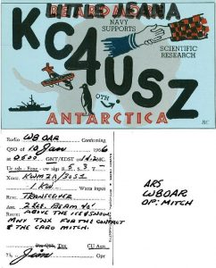
The KC4USZ card , prove that an activity on Jan. 10th 1966 from this epic rare one by a QSO made with W8OAR!
US Station Little Jeana.
The Bulletin of the Antarctic US Projects officer (Vol.6 number 2-1964), signed by Rear Admiral James R. Reedy, USN United States Antarctic Projects Officer, show a presentation of activities of the Government of the United States of America pertaining to the logistic support, scientific programs, and current events of interest in Antarctica, published monthly during the austral summer season and distributed to organizations, groups, and individuals interested in United States Antarctic activities.
The data in the over mentioned issues suggest that Little Jeana was active from 3 oct.64 to 23 feb.65, from 2 oct.65 to 31 oct.65 and again from 1 dec.65 to 22 jan.66.
SUMMER WEATHER STATIONS REESTABLISHED
Prior to the first aircraft landing at the South Pole, on 31 October 1956, a summer weather and emergency-landing station (Beardmore I Station WAP USA-NEW) was established at the foot of Liv Glacier . This station was later moved to the foot of the Glacier, from which it derived its name, and has been moved or rebuilt several times since.
When aircraft began to resupply Byrd Station (WAP USA-19), another summer weather station, Little Rockford (WAP USA-NEW), was set up on the flight path from McMurdo Sound to Byrd Station. It has also been relocated, at 79°14′ South, 147°29′ West, on the Rockefeller Plateau.
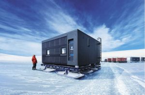
Plans for the current season called for remodeling the 2 stations, using van-type buildings similar to those that have proved successful at Eights Station (WAP USA-Ø7).
Advantage was taken of the opportunity to shift the location of Beardmore Station (WAP USA-NEW) to 81°23′ South, 170°15′ East, about 125 miles north of the previous site.
 At the same time the station has been renamed “Little Jeana Summer Weather Station” and officially opened on 5 October 1964. The installation consists of 4 portable units, 3 of which are arranged in a “U”. In one are the sleeping and eating quarters for the 3-mandetach-ment; in another are a diesel generator and a workshop; while the third contains another generator and a wash room.
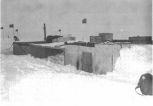
Picture aside (20 February 1964), shows an exterior view of berthing wanigan with messing wanigan in background at Little Rockford Summer Weather Station.
.
.
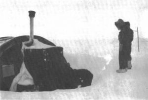 Wintering-over party shovelling out the James-way but at Beardmore Summer Weather Station for activating the station. (29 September 1961.)
The center of the “U” has been turned into a permawalk, and here the pibal dome is located. The fourth unit has communications equipment and is separated from the others sothat it may, if needed, serve as an emergency shelter.
Little Rockford was reestablished the same day Little Jeana was opened. This installation has consisted of wanigans that were put in position in 1958 by tractors from Little America and later moved to the present site by the same means. It is intended to remodel Little Rockford, along the lines of Little Jeana, later in the season.
Source: Bulletin of the Antarctic US Projects officer (Vol.6 number 2-1964) – Ricerca Google
More details are available at: https://amrc.ssec.wisc.edu/usap/brockton/NCDC-WBAN.TXT
Dates: 1964 October 01, through 1966 January 31Location: 81° 23’ 00” South, 170° 45’ 00” West on Ross Ice ShelfElevation: 178 feet POBvVIIndex and Errata (1).pdf
Little Jeana was a “summer weather station”.
Bulletin of the U. S. Antarctic Projects Officer – United States. Antarctic Projects Office – Google Books
Bulletin 1, December 1964, reports:
Beardmore station will be relocated at 81° 23’ 00” South, 170° 45’ 00” West and renamed Little Jeana Station .
Two of such stations, one on the flight path between McMurdo and Byrd was named Little Rockford, while on the flight path from McMurdo to Amundsen-Scott the other one was Little Jeana.
Bulletin 2, January 1965 says: Little Jeana Station officially opened 5 October 1964.
4 wanigans (Wanigan is by definition, a shelter used for sleeping, eating, or storage, often mounted in Antarctica on a sledge), typical formation 3 in U-shape, and the 4th one separated for communications and in case of emergency. These four pieces were the setup for the use of 3 people. 2 for 1800-gallon fuel tanks to be installed (bladder technology used instead).
Bulletin 4 says: “…. manned by 3 Navy aerographers who broadcast weather conditions hourly”. Summer support season = 1 October through 1 March.
Bulletin 5, 8 February 1965 says: Communications van returned to McMurdo, digging out of station commenced. On 24 February 1965 Little Jeana closed for the season, personnel and equipment moved to McMurdo, but as reported above, other documents clearly states the activities from Little Jeana were: 3 oct.64 to 23 feb.65, from 2 oct.65 to 31 oct.65 and again from dec. 1st 1965 to jan. 22nd 1966.
TNX Bill Ashley KF5BRB for his invaluable help
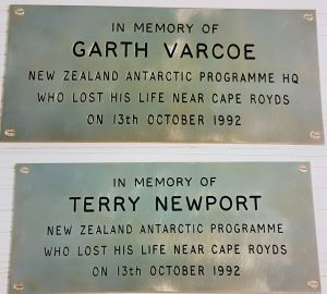 Antarctic New Zealand reports that today, oct. 13 2021, Scott Base observed a few minutes of silence to remember two of our own. Kiwis Garth Varcoe and Terry Newport were tragically killed in a helicopter crash in 1992 while returning from a maintenance trip to the Hut at Cape Bird.
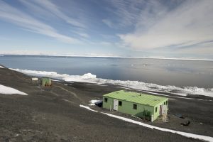 Cape Bird Hut on Ross Island, Antarctica at 77°13’ 05” South, 166°26’ 09”East was a shelter, built in 1966 with the name of Harrison Laboratory, in order to give a facility to the researchers working at Cape Bird.
 Years ago, for us Radioamateurs, it was quite easy to work the New Zealand Scott Base on HF and it was a fantastic experience for many of the lucky Hams. On the last years, nobody was able to be active from there!
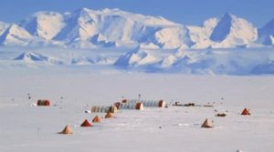
 Pavlo Tarasovych UT1KY from RIVNE, Ukraina is an Antarctic veteran with several seasons spent at Akademic Vernadsky Base (WAP UKR-Ø1). Pavlo did also operate from James Wordie Hut (WAP GBR-Ø7) signing VP8/UT1KY on last 2000, giving many Hams world wide a new one!
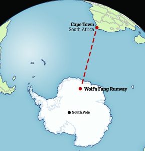 Oleg, ZS1ANF who did operate as ZS7ANF and RI1ANX from Wolf’s Fang Runway (
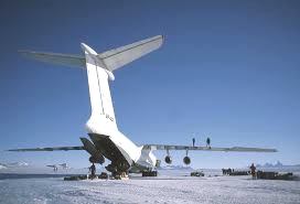 Wolf’s Fang Runway is located 71° 31′ South, 08° 48′ East, 1127m AMSL. The Runway is 3000 mts long and 60 mts wide. The fuel supply for aircrafts that land and take off at Wolf’s Fang, is possible with the assistance of the South Africa’s science vessel. The fuel supply is delivered to the edge of Antarctica, where a traverse Team embarks on a journey of 800 km across the Fimbul ice shelf to Wols’s Fang Runway.
 While analysing ice core samples taken from James Ross Island in Antarctica, scientists from the British Antarctic Survey noticed something unexpected – the levels of black carbon or soot, began to increase drammatically about 700 years ago..
 François, F8DVD, will operate
  Carlos Andrés Molina Vera, CX8ABF has informed WAP that the Telecommunications Administration of Uruguay (URSEC) has issued a Special Call CW6ØATS to celebrate the 6Øth Anniversary of the Antarctic Treaty Signature.
 We hope some day in the next Antarctic Sesons, pne of the researchers can activate Artigas Base again and maybe also, Teniente de Navio Ruperto Elichiribehety Stations which has never been activated!
 Info Radio News ( WEB
  Antarctic Treaty entered into force on June 23rd, 1961, covering demilitarization of the Antarctic region, its use for exclusively peaceful purposes and transformation into a zone free of nuclear weapons.
 WAP IND-Ø3–MAITRI Research Base (70° 45’58” South, ; 11° 43’56” East) is located in Schirmacher Oasis Central Dronning Maud Land. It is an inland station nearly 100km from the edge of Lazarev ice shelf (Indian Barrier for Ship)
 Kizahashi Hut is located at 69°28’ South, 39°35’ East in a beach at the headland on Skarvsnes, one of the islands of the Flatvaer group on the coast of Queen Maud Land.
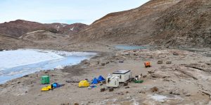 Kizahashi Hut at Skarvsnes stands among a field camp which consists of the main hut, a generator hut, a small (green) lab hut and a series of small tents for sleeping and work. The North Face dome tent is a science tent.
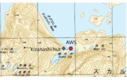
 RI-Mondovì (Cuneo) Italy, will run the
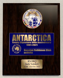
 Thanks to Eugene RZ3EC, we have received a sample of the
  Sovetskaya , 77° 58’ South, 89° 16 East was a Soviet research station in Kaiser Wilhelm Land in Antarctica that was established on 16 February 1958 by the 3rd Soviet Antarctic Expedition on International Geophisic Year research work, and closed on 3 January 1959.
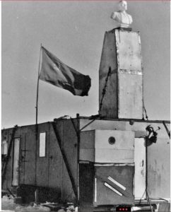 Pole of inaccessibility (
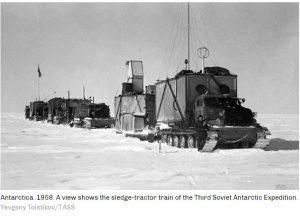 The site was occupied for only two weeks, until the official end of the IGY, then abandoned, though the shelters and basic equipment were left intact for future use.
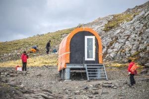 Collins Refuge, 62º 10’ South, 58º 50’ 57” West, is an Antarctic shelter located in the Collins Glacier in the Collins Bay, Fildes Peninsula, King George Island.
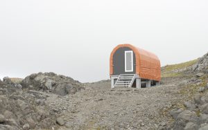 The Collins Refuge stands as one of the main housing supports on the ground for Antarctic work in Fildes Bay with a laboratory module as well as magnifying glasses and microscopes are available. A laboratory module as well as magnifying glasses and microscopes are available.
 The Center for Oldest Ice Exploration, or
  Located at 62° 15’ South, 58° 59’ West on Nelson island the Refuge consists of a shipping container, flanked by two smaller containers. The main building contains several bunk-beds, a large amount of assorted bedding and blankets and a small store of water bottles, fruit juice and medicine.
 On last August 30, 2021, a ceremony was held at the facility of the Ministry of National
 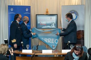 Defense. The Uruguayan Mail, following the request of the Uruguayan Antarctc Institute, presented a commemorative stamp, celebrating the 30th Anniversary of the first Antarctic naval mission aboard the ship “Pedro Campbell”
 Antarctic region, its use for exclusively peaceful purposes and transformation into a zone free of nuclear weapons.
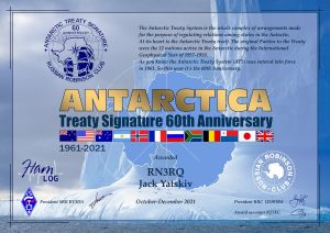
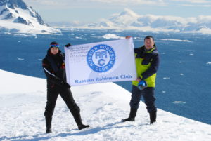 Russian Robinson Club together with SRR and HAMLOG.Online will issue a special award and plaque
 Dr Ruzica Dadic says there are complicated relationships between Antarctic snow and ice with feedback loops that need to be better understood as climate warms. The mysteries of how snow affects Antarctic sea ice remain largely unknown.
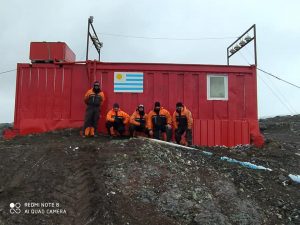 Uruguayan Ionospheric Refuge 62°10′59.4′′ South, 58°54′31.6′′ West, takes its name by Ionospheric Lake Uruguay in its proximity. Recently an Uruguayan crew put their manual skills on full blast, and in a great teamwork. They refurbished the shelter located about 800 meters from the Artigas Antarctic Scientific Base (WAP URY-Ø1), which can be used in case of evacuation.
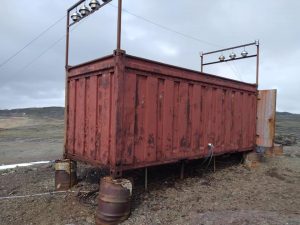
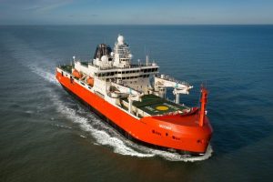 The design and build of the vessel has been a multi-national effort between the Australian Antarctic Division, the vessel operator Serco, Danish concept designers Knud E Hansen, Dutch engineering and detailed design team Damen, and the construction team at Damen Shipyards Galati in Romania.
 Ukraina whose presence in Antarctica is dated 1995-1996, has followed the 6Ø ATS (AntarcticTreaty Signature) celebration, by putting a Special Event Station on the air.
 This is the second time that a UK research asset has transferred to Ukrainian research colleagues. The first being the transfer in 1996 of the former Faraday Station
  DS4NMJ Lee, Sanghoon is still active as DT8A from King Sejong a year-round station , one of the two Korean Bases in Antarctica where he will operate until December 31st , 2021.
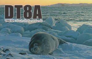
 There is a nice article published on last June 2021 by “Science Focus”.
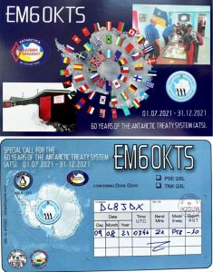
 Day by day, several Hams from different nations are showing up with Special callsigns to join the 6Ø years Anniversary of the Antarctic Treaty Signature.
 D Q 6 Ø A N T
 A small group of Enthusiastic USKA members (Union of Swiss Shortwave Radio Amateurs) will put the special call sign HB6ØANT, in support and reminder that this contract will be preserved, on the airwaves beginning in mid-August through December 31, 2021.
 Observation Hill is also known for being the site where a Cross was erected as memorial to Robert Falcon Scott and his South Pole Party.
 This “brief life” Research site, was very singular! It was set on Pobeda Ice Island (original Russian name “Oстров Победы” aka Victory Island) in the Mawson Sea, about 160 km off the coast of Queen Mary Land, East Antarctca.
 winter solstice in Antarctica, the crew at Concordia Research Station (WAP MNB-Ø3) are slowly welcoming the return of sunlight.
  In a document sent to the Secretariat of the Antarctic Treaty
  regarding the “Italian activities in Antarctica before the establishment of the PNRA” (and shown during the Consultative Meeting in Paris last June 2021) there is a paragraph concerning the expedition of
  The largest and only independent Italian Antarctic Expedition was led by Renato Cepparo in 1976-77 to the South Shetland Islands by the Norwegian ship P/V Rig Mate.
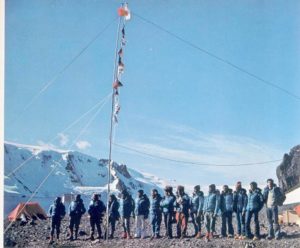 The area still keeps the name Italia Valley.
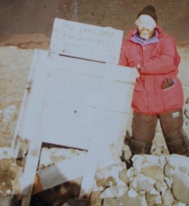 Remains of Giacomo Bove Station (Cepparo’s Team did operate HF radio using I1SR/P callsign)- Picture taken in 1998.
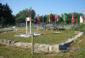 Pic on the Left shows;
 A real honor for me, for the relatives of Renato Cepparo and Giacomo Bove as well as for students, families, associations, partners and patrons. The Giacomo Bove and Maranzana (AT) Association and the Cultural Adri-Antartica Association, founders of the actually constituted National Consortium. All together, say thank you to all the supporters, to friends and families. Thanks to the late H.E. Ambassador Arduino Raimondo Fornara, yp Commander Gen. Amedeo Amedeo G. Cristofaro, to H.E. Ambassador Pier Francesco Zazo, graduated with prof. Silvio Zavatti.»
 McMurdo Station has no permanent residents — just a revolving door of visiting scientists and temporary personnel, some of whom live there for up to a year at a time. At its most populous, typically during the summer, it houses about 1,000 people.
 The Unión Glacier, located at 79º 46’ South, 83º 24’ West, is a large glacier converted since 2014 into the Base Camp.
 In 2013 during the 68th Chilean Antarctic Campaign (ECA 50), the Polar Stations Arturo Parodi Alister (WAP CHL-14) –Picture here on the Right shows the entrance of Arturo Parodi Alister Base – established at Patriot Hills in 1996, and Antonio Huneeus Gana, were dismantled. Their equipments moved to the corridors of the future station, the Unión Glacier joint scientific polar station.
 Japan will soon begin working toward construction of a new Antarctic base to continue with research into climate change over the past 1 million years.
 Endurance22 will launch early next year with aim of locating and surveying wreck of Sir Ernest Shackleton’s ship Endurance in the Weddell Sea.
 There is a very important person, leading expert of the Russian Antarctic Expedition of the Arctic and Antarctic Research Institute, one of the few people to receive the Order “For Naval Merit” (Russian: Орден «За морские заслуги»), a state decoration of the Russian Federation bestowed for excellence in military or economic maritime endeavours, Awarded for Excellence in worldwide oceanic activities in favour of Russian military and economic security.

 Now climate change is undermining that success story. About 90% of the world’s surface fresh water is locked up in the Antarctic Ice Sheet and, as the planet heats up, glaciers whose collapse would deluge coastal cities from New York to Jakarta are melting and growing less stable.
 Asuka Station, located at 71°31’29’’South, 24°07’50’’East, altitude: 980.3mts was established in March, 1985 in Dronning Maud Land, 670 km southwest of Syowa Station (WAP JPN-Ø3).
 Ice is thick in this particular region, and therefore extremely difficult to access. In 2012, the latest research vessel “Siras” could not even come close to the shore. Since that time, Japan was the country that lost the war, some thought that it had the unfortunate fate. However, as a result, this place was favorable for study and research.
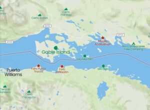 Gable Island (Isla Gable) is an Argentine island belonging to the Ushuaia Department of Tierra del Fuego Province of, Antarctica and the South Atlantic Islands in Argentina.
 The German Research Icebreaker Polarstern with the Call DPØPOL/MM (Op: Andreas, DL3LRM) will be active again in November/December 2021, still on time to join the 60th Anniversary of the Antarctic Treaty Signature. DPØPOL/MM will be
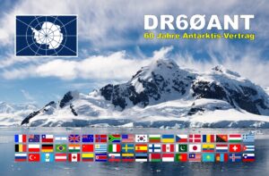
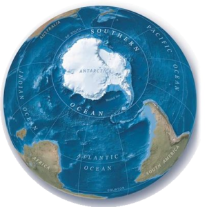 Update your atlas: Southern Ocean recognised as world’s fifth ocean by Nat Geo cartographers