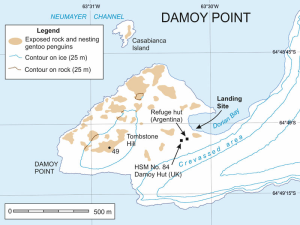
 Damoy Point is a headland 900 metres west-northwest of Flag Point, the northern entrance point to the harbour of Port Lockroy, on the western side of Wiencke Island in the Palmer Archipelago of Antarctica. It was discovered and named by the French Antarctic Expedition, 1903–05, under Jean-Baptiste Charcot.
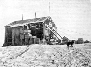
Wiencke Island 64° 49′ 22″ South, 63° 23′ 14″ West, is an island 6 km long and from 3 to 8 km wide, about 67 km2 in area, the southernmost of the major islands of the Palmenr Archipelago Two structures were erected on the shores of Dorian Bay; the Argentinean Refugio Bahia Dorian (WAP ARG-24) in 1957, and a larger building known as the 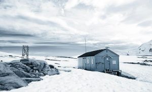 Damoy Hut in 1973 and used for several years as a British summer air facility and transit station for scientific personnel. It was last occupied in 1993, where it served flights to and from a summer-use ice-strip for aircraft used before the sea-ice cleared near Rothera Base. The Damoy Hut (aka Station L) and its ice-strip were closed in 1995: the building is now listed as an Historic Site and Monument and is maintained and administered by the United Kingdom Antarctic Heritage Trust (UKAHT).
Both Argentinean Refugio Bahia Dorian (WAP ARG-24) and Damoy Hut (Station L) WAP GBR-31 have been activated by F5PFP signing respectively LU/FT5YJ and VP8DLM on March 2009. WAP does not have evidence of any other Ham radio activity before that date.
Find out more about Historic Site and Monument No. 84 by watching a short video on Damoy Hut. The site is Antarctica’s only protected historic transit facility and skyway, providing shelter and safe passage for scientists. (Courtesy of UKAHT)
Damoy is a well-preserved Hut containing scientific equipment and other artifacts was. It has been designated a Historic Site or Monument (HSM 84), following a proposal by the United Kingdom to the Antarcti Treaty Consultative Meeting.
For many, this was where they made their first Antarctic landing by ship. “As a first landfall in Antarctica it was hard to beat,” enthuses Steve Garrett, geophysicist. “Surely a candidate for the most beautiful place on Earth.”
The Hut became redundant in 1993 and by 2007 the building was due for demolition. However, it was saved and preserved as “an excellent example of Antarctic logistics and early air operations in Antarctica” helping us to understand the operational challenges of working in Antarctica. It takes its place as Historic Site and Monument No. 84 – one of only 33 buildings, and the sole transit facility, on the continent protected by the Antarctic Treaty.
 In 2023, UKART restored the Hut back to its original bright orange. The decision followed paint sampling by our conservation team in 2018 and research by paint scientist and conservator, Phillipa McDonnell, in 2019. The restoration of the original colour scheme improved the legibility of the Hut’s historic function as a transit centre and provides a key hook for the improved interpretation of the site as a whole as well as protecting it from the elements.
The work was undertaken by a small field team of one field guide and two conservation carpenters experienced in conserving historic buildings. They spent nearly four weeks on-site from mid-January, working around challenging weather to strip back the existing paint by hand, prime, and repaint the building to its original bright orange. As with any UKAHT conservation work, the team adhered to strict methodologies to ensure no contamination of the surrounding environment.
.
Thanks and credit to: https://www.ukaht.org/
 There is still a big demand of contact with Polar Ships and even if some have been worked recently there are other hard to get!
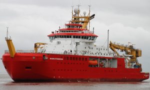
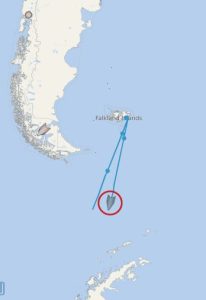 Here is the spot : “ I am due back on board the RRS Sir David Attenborough in late March 2023, completing the end of the 22/23 Antarctic season with visits to Bird Island, South Georgia and Rothera, then bringing the ship north to the UK arriving 30th May.
 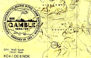 GANOVEX VII Multinational expedition was again funded by the Federal Agency for Geosciences and Natural Resources (BGR). Expedition leader was Dr. Roland, the ship “PolarQueen” was used, researchers from the various institutes BGR, AWI, DLR, Uni Frankfurt/M and others as well as from Holland, USA and New Zealand were involved, the Americans and a team from Australia took care of the helicopter service.
 About Werner Thonhauser, OE8NOK (
 Sobral Scientific Base ( Base Base Científica Sobral or Base Sobral) was a permanent, all year-round and now only partially active Argentine Antarctic base and scientific Research Station located on the Filchner Ice Shelf at 81°04′05″South, 40°36′01″West. It bears its name in honor of the late 19th and early 20th century Argentine explorer Ensign José María Sobral, who had joined Dr. Otto Nordenskjöld’s ill-fated Swedish Antarctic expedition in 1903. Josè Maria Sobral was the first Argentine known to winter in Antarctica.
 After 23 days of exploration, using nine days to go and four to return, they successfully returned to the Belgrano II leaving written testimonies in plastic tubes and marking the path with reeds and banners. After 14 years of this last reactivation, it was not possible to find it in 1997 when a patrol of 4 men from Belgrano II Base went in search of it. That patrol identified the place where the base should be located and established fuel depots for future operations in the region.
 On 10 October 2000 a six-men research expedition established a scientific camp at Sobral’s emplacement and measured local ozone levels with a spectrophotometer. The temporary occupation was conducted by personnel belonging to Belgrano II and a technician from the National Antarctic Directorate; since then, a new expedition is sent every year between September and December, where the lowest annual average concentration of ozone in Antarctica is recorded.
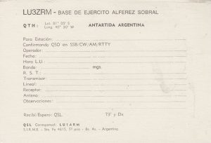 vehicles are used to cover half of the route; light vehicles like the Yamaha VK-540 II Ski-Doo are preferred for the rest. The party carries all the necessary equipment for a three-months stay, such as tents, fuel, supplies, survival kits, communication hardware and scientific instruments.
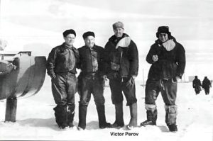 Viktor Perov piloted aircraft serving the Polar Stations SP-2, SP-3, SP-4 and SP-5. While working in the Arctic, Perov had to rescue people in distress more than once. In 1956, he participated in the rescue of the Norwegian-Swedish-Soviet expedition to Svalbard.
 The situation was complicated by the unexplored terrain, which the Belgians flew out to map. After several days of searching, on December 16, the Belgian polar explorers were found and rescued. For this feat, Viktor Perov was awarded the Order of Leopold II in 1959, and the Order of the Crown in 2001.
 Nordenskjöld’s Hut aka Nordenskjöld House (
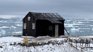 The Argentine Navy took possession of the Refuge on January 8, 1954, renaming it Refugio Suecia and proceeded to its restoration. On that day the frigate Captain Luis T. De Villalobos, commander of the transport ARA Bahia Aguirre, took possession of the Refuge facilities on behalf of the Government of the Argentine Republic and recorded the new name. On the same day in its vicinity the Betbeder Naval Shelter was built. The Hut was used as a base for reconnaissance research in the summers of 1953-1954 and 1954-1955. In the early 1960s it had a warehouse with provisions for three people for three months.
 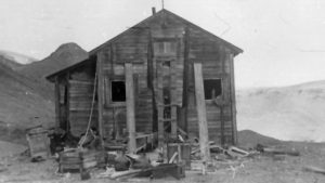 The leader of the expedition had to spend the winter on the island along with meteorologist Gösta Bodman, sailor Gustav Akerlund, all of them of Swedish nationality, and Argentine Josè Maria Sobral, ensign. They would carry out meteorological, magnetic, astronomical and hydrographic work, as well as expeditions on the sea ice to the neighboring islands and to the nearby area of the Antarctic Peninsula, a region later known as the Nordenskjold Coast, and which extends to the southwest of the island.
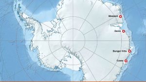
 A new deep-Field Camp has been established in the Bunger Hills, near the Denman Glacier in East Antarctica, for scientists to begin studying climate change impacts in the region.