Volker Strecke DL8JDX is touring around Antarctica on board of a cruise Ship. Yesterday Volker sends WAP a couple of pictures; one of this is the Refuge Armada Argentina, also known as Groussac Refuge (WAP ARG-18) on Petermann island, a small, low and rounded island, lying off the northwest coast of Kyiv in Graham Land, Antarctica, a short distance south of Booth Island and the Lemaire Channel. It is a popular tourist destination.
Opened on February 6, 1955, Grussac Naval refuge (65° 10’ 33” South, 64° 08’ 10” West), on Petermann Island, was originally named to Hipólito Bouchard., It takes its current name in homage to Paul Groussac (1848-1929), a French writer and historian based in Argentina and author of an allegation about the Argentine sovereignty of the Falkland Islands. Close to this Argentine naval refuge ( an old corrugated iron shack in rusted colors), lays a simple cross monument, an unreadable metal plaque with just one word “John” recalls the dead of a man of the British Antarctic Survey, who tried to get here over the sea ice in 1982..
On Peterman Island, there is a cairn (the original one is in Paris at Museum National d’Histoire Naturelle) erected on the hill in 1909. The cairn, with a replica plaque, has been designated a Historical site or Monument (HSM 27), following a proposal by Argentina, France and the United Kingdom.
Cape Adare is a prominent cape of black basalt forming the northern tip of the Adare Peninsula and the north-easternmost extremity of Victoria Land, East Antarctica and an important landing site and Base Camp during early Antarctic Exploration.
Cape Adare is the site of Borchgrevink’s Hut, and Terra Nova Expedition’s Hut where members of the Northern Party of Scott’s Terra Nova Expedition over-wintered in 1911 and 1912. They also erected another hut, which has fallen into ruin today., This site have been designated a Histopric Site or Monument (HSM 22), following a proposal by New Zealand and the United Kingdom to the Antarctic Treaty Consultative Meeting. This site belongs and his administered by New Zealand.
As yet, there is no evidence of amateur radio activity being performed from this site, so it remains listed on WAP-WADA Directory as WAP NZL-NEW.
Map above show both Adare Cape and Hallett Cape
Cape Hallett, located 63 miles (101 km) to the South of Cape Adare, is a snow-free area on the northern tip of the Hallett Pensula on the Ross Sea coast of Victoria Land, East Antarctica. he cape was the location of a joint scientific base, Hallett Station, (WAP MNB-08) between the United States and New Zealand during the International Geophisical Year of 1957, and was manned permanently until 1964, when there was a major fire. It was then used as a summer only base until 1973.
.
The callsign of Hallett Base (WAP MNB-08) was KC4USH; with several QSLs issued (See pics here aside); some of KC4USH QSL cards, reports Cape Adarewhich was probably meant to be Cape Hallett.
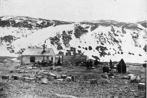
In 1899 the Norwegian explorer Carsten Borchgrevink sailed to Antarctica aboard the converted scaler Southern Cross. At Cape Adare, Borchgrevink and nine companions built a Hut and established an expedition Base Camp. During the next six months, Borchgrevink and his team became the first men to overwinter on the southern continent. A 28-year-old zoologist in the party died and became the first individual buried on the continent. When Borchgrevink returned to Europe in the spring of 1900, he had, in effect, started a race for the South Pole that would be won in 1911 by his boyhood friend, Roald Amundsen.
The site was revisited both by Robert Falcon Scott’s British National Antarctic Expedition (1901-1904) and by his Terra Nova expedition (1910-1913). Pic below show the Borchgrevink’s Hut
Members of the Northern Party of Scott’s Terra Nova Expedition over-wintered at Cape Adare in 1911 and 1912. They also erected one hut, which has fallen into ruin today. The remains of two Borchgrevink’s Hut, as well as those of the Terra Nova Expedition’s hut, have also been designated a Histpric Site or Monument(HSM#22), following a proposal by New Zealand and the United Kingdom to the Antarctic Treaty Consultative Meeting.
Check page 154/157 for some mention of Cape Hallett/Adare
It was Norwegian explorer, Carsten Borchgrevink and his expedition team who started building the huts on 20 February 1899 on the remote site. The main Living Hut was constructed to house the expedition party along with a Stores Hut for their provisions. The party moved in a few days later, on 1 March, the day the Southern Cross sailed, leaving the men to spend several months in cramped, uncomfortable isolation. On 24 July 1899, it was lucky one of the buildings survived, when a candle set the hut lining alight. Later in the year, one of the men, Nicolai Hanson, suffered a debilitating illness, and died in the hut on 14 October 1899, becoming the first person to die on the Antarctic Continent.
When the Southern Cross returned for the party on 28 January 1900, the men started to dismantle the Stores Hut, removing its roof, with the intention of taking it with them to use elsewhere. However, they left on 2 February 1900 before completing this task and it wasn’t until 18 February 1911 that the Huts at Cape Adare were occupied again, following the arrival of Scott’s Northern Party (led by Victor Campbell). As well as erecting their own kitset wooden hut, they made good use of what was left of Borchgrevink’s encampment, covering the unroofed Stores Hut with canvas to make a storeroom, and utilizing the Living Hut as a gymnasium and darkroom.
Since the Northern Party’s departure from Cape Adare, there have been only sporadic visits to the remote site. New Zealand parties visited a couple of times during the 1960s and 70s to undertake repairs, before Canterbury Museum sent an expedition party to the site in 1982 to carry out maintenance work, complete drawings of the huts, and document the artefacts.
The first party from Antarctic Heritage Trust visited in 1990 and carried out significant preservation works to the huts. This focus continued on the Trust’s next visit in 2003, when condition reports for the artefacts were also completed.
More latterly, during the summer season of 2015–2016, a small team from the Trust spent two weeks at Cape Adare gathering close to 1500 artefacts from one of the huts and carrying out further repairs and maintenance. The artefacts were later conserved in Christchurch, and seven of these very special items now feature on the Trust’s AR App.
Our friend Volker Strecke DL8JDX is an Antarctic veteran who spend several years in the Icy Continent.
After a 19 hours flight, Volker did land at Ushuaia (WAP ARG-23), then he moved to Punta Arenas-Chile, where he had a chance to meet Luis CE8EIO (picture aside show DL8JDX meeting with Luis CE8EIO in Punta Arenas in Front of the Magellan Memorial).
.
Volker did ask Luisto be on air for EU and indeed CE8EIO has been on 28508 all afternoon of Saturday Jan. 21 making some hundred QSOs with EU, giving many a chance to log WAP CHL-13 (TNX DL8JDX & CE8EIO).
.
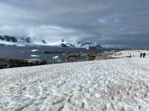
Actually, Volker is embarked on a cruise ship as a lecturer and Tour Guide (no possibility for Radio… ) at an Antarctica expedition. The trip is including Argentina, Chile, South Shetland Islands and Antarctic Peninsula and will last till Feb. 18th, 2023.
The cruise is going to South Shetlands and Antarctic Peninsula were visiting King George Isl., Half-Moon-Island, Port Locktoy, Melchior Island and Petermann Island.
.
Yesterday, jan 21st, the Polar ship passed near Half Moon Island where the Argentine Summer Station Teniente Camara (WAP ARG-16) is located (see the pic aside sent by Volker)
Volker said:“After 29 years from my last return from the Antarctic in 1994 I am really happy to be back here again. In my second home …”
.
WAP is proud and happy to follow the trip, pity that it is not possible to do radio activity from there, but we thanks VolkerDL8JDX anyway to share his new experience with us!
Nearly 15 years ago, a major restoration project had been taking place at the old abandoned whaling station at Port Jeanne d’Arc. This had been built late in the 19th century by a Norwegian company and abandoned early last century when factory ships made land-based whaling uneconomic. For years the weather and vandalism had been destroying the station, until Jean-François Le Mouëlconvinced the administration of TAAFthat it should be preserved.
The Kerguelen Islands are located at 49°15′South, 69°35′East. The main island, Grande Terre, originally called Desolation Island, is 6,675 km² and it is surrounded by another 300 smaller islands and islets, forming an archipelago of 7,215 km². Satellite Islands The following is a list of the most important adjacent islands: Île Foch in the north of the archipelago, at 49°0’ South, 67°19’ East, is the largest satellite island with an area of 206.2 km² (79.61 mi²). Its highest point, at 687 m (2,254 ft.), is called La Pyramide Mexicaine. Île Howe, which lies less than one kilometer off the northern coast of Ile Foch is, at ~54 km² (21 mi²), the second most important off-lier in the Kerguelens, 48°52’South, 69°27’ East. Île Saint-Lanne Gramont, is to the west of Île Foch in the Golfe Choiseul. It has an area of 45.8 km² (17.68 mi²). Its highest point reaches 480 m (1,575 ft.), 48°55’South, 69°12’ East. Île du Port, also in the north in the Golfe des Baleiniers at 49°11’South, 69°36’ East, is the third largest satellite island with an area of 43 km² (16.6 mi²); near its center it reaches an altitude of 340 m (1,115 ft.). Ile de l’Ouest, west coast, about 40 km² (15.44 mi²), 49°21’South, 68°44’ East. Île Longue, southeast, about 40 km² (15.44 mi²), 49°32’South, 69°54’ East is the largest island in the Golfe du Morbihan. Port-Bizet, on the northeastern coast of the island, is the site of a seismographic station and also served until 2012 as the principal farm for the island’s resident flock of about 3,500 Bizet sheep, which were raised to feed the base personnel at Port-aux-Français. The species, endemic to the Massif Central region of France, was first introduced to Kerguelen in 1952. Îles Nuageuses, northwest, including Île de Croÿ, Île du Roland, Îles Ternay, Îles d’Après, 48°37’South, 68°44’ East. Île de Castries, 48°41’South, 69°29’ East. Îles Leygues, north, including Île de Castries, Île Dauphine, 48°41’South, 69°29’ East. Île Violette, 49°07’South, 69°40’ East.
Île aux Rennes, also known as Reindeer Island or Australia Island, in the western part of the Golfe du Morbihan, area 36.7 km² (14.17 mi²), altitude 199 m (653 ft.), 49°27’South, 69°51’ East. Île Haute, western part of the Golfe du Morbihan, altitude 321 m (1,053 ft.), 49°23’South, 69°55’ East. Île Mayès, 49°28’20”South, 69°55’55” East.
Here below an abstract of the history:
The exploitation of marine resources on the Kerguelen Plateau only began in 1790 (18th century) after the discovery of the northern Kerguelen Islands in 1772. Salted fur seal (Arctocephalus gazella) skins was the first product to be commercialized by Nantucket (USA) and London (UK) ship-owners, mainly on the Kerguelen Islands, and by the early 19th century the seal colonies were decimated.
https://youtu.be/dwAcpFxBGzE
Exploitation of marine species on the Kerguelen Plateau began soon after the discovery on 13th February 1772 of the northern Kerguelen islands by the expedition of Y.J. de Kerguelen de Trémarec with the Gros Ventre and the Fortune.
The first sealing voyages (1791-1793) were reported from the United States of America and United Kingdom twenty years later. For more than 50 years during this early period, sealing occurred only around the Kerguelen islands. It was only with the development of whaling and sealing voyages in the region that sealers from the north-eastern coast of the USA discovered the second and southern sealing ground on the plateau, Heard and mcDonald islands, during the 1853-1855 cruise of Corinthian. The exploitation of marine resources on the Kerguelen Plateau only began in 1790 (18 th century) after the discovery of the northern Kerguelen islands in 1772. salted fur seal (Arctocephalus gazella) skins was the first product to be commercialized by Nantucket (usa) and london (uK) ship-owners, mainly on t Phase 1, 1908-1911: the whaling station at Port Jeanne d’Arc and the Mangoro campaign (1910).
A 50-years exclusive licence was granted to the Bossière brothers by the French government in 31 July 1897 for the exploitation of the Kerguelen Islands. During the rst period (1908-1911) they transferred the rights to two companies, Aktieselskabet Kerguelen and Société des Pêcheries de Kerguelen (Arnaud and Beurois, 1996). Storm, Bull & Co. which was active from 1908-1911 established a whaling factory station at Port-Jeanne d’Arc in Morbihan Bay.
The oil carrier Jeanne d’Arc (76 m, 1332 t) and three whale catchers (two sister ships Espoir and Éclair, 51 m, 540 t, and Etoile, 30 m, 165 t) were linked to the station. The total whale catch resulting from this activity was 442 whales (95% humpback, the balance right whales). Their best year was in 1908 when 232 whales were caught and a total of 13 760 barrels of oil were produced. Activity progressively shifted to hunting elephant seals with peak production in 1911 of 10 680 barrels and a total production of 17 000 barrels of oil. However, the activity was not profitable enough and the station fell into disuse.
Another 3 entries on the 20th AAW going to start next february 19, 2023.
Austria with its 4 participants, appears to be the most represented Country.
.
Congratulations to OE3DMA, OE3KKA, OE3AIS and OE3SGA for their continued presence to celebrate the annual event that leads to being close to Antarctica, to the scientific research, in memory of so many explorers and scientists who have been studying and working in this fascinating Continent for over 100 years.
After six days of activities on the White Continent, a new version of the Antarctic School Expedition (EAE) organized by the Chilean Antarctic Institute (INACH) ended successfully. In this instance, the winning students of the XVIII Antarctic School Fair (FAE) participated in the company of their teachers and adult guides, who were able to comply with a scientific program that allowed them to learn about the work of polar researchers.
The group was made up of eight young people (all women) from the communes of Arica, Talagante, Linares, Parral, Constitución and Futaleufú, who were accompanied by four teachers and two adult guides. Between December 13 and 19 they were on King George Island to complete an interesting scientific-pedagogical program prepared by INACH professionals. The operations center was the Professor Julio Escudero base (WAP CHL-Ø7), where they were received by their chief scientist, the marine biologist Francisco Santa Cruz, and were introduced to the scientists who carry out their research in the sector, in addition to the logistics personnel who were there.
ARA Libertad is a tall ship which serves as a school ship in the Argentine Navy. She was built in the 1950s at the Rio Santiago shipyards near Buenos Aires, Argentina. Her maiden voyage was in 1962, and she continues to be a school ship with yearly instruction voyages for the graduating naval cadets.
She has just finished (April 2007) undergoing a general overhaul which includes the addition of facilities for female cadets and crew in line with current diversity policies in the Navy and the updating of the engines and navigation technology.
The Directorate of Communications of the Argentine Navy through the Auxiliary Service of Radio Amateurs of the Navy, issue a special free cerificate to the Hams who worked LU8AEU/MM, Fragata A.R.A Libertad during her training trip “Number 50” in the past year 2022
You will enter into the form which has to be filled (Callsign, Name and Surname in capitol letters, your email where you wish to receive the Certificate, GMT time, Band and mode). When you finished, press SEND. Certificate will shortly come at your mailbox adress.
. TNX SARA-Servicio Auxiliar de Radioficionados de la Armada
Master roofer Dimitris Georgiadis (picture aside) will leave for Antarctica in mid-January and will be there until March. He will travel to the icy continent with scientists from Masaryk University in Brno, who are investigating climate change in Antarctica and solving dozens of research projects, including the effect of harsh polar conditions on the human organism.
The Mendel Polar Station (WAP CZE-NEW) on James Ross Island near the Antarctic Peninsula (see picture to the Right) is a showcase of Czech science. The master roofer must now ensure that it does not leak. On the main building of 250 square meters, he will lay a new PVC film with the help of a heat gun. If the weather is favorable, with the help of two technicians from the expedition, he will have everything ready in a week or so.
Then, in turn, he will help the technicians maintain the station while looking over the researchers’ shoulders as cutting-edge science is done. “I’m really looking forward to that too” Dimitris added with a smile, “I’m curious what awaits me. I have never driven so far for work”.
His task will be to put a new roof on Johan Gregor Mendel’s scientific base; the original expired after 15 years.
Pavel Kapler, manager of the Czech Antarctic Research Program, can find anything for polar explorers, from new technical equipment for the station to quality thermal underwear, but getting a roofer to Antarctica was a chore. In the mean while, ther’s some possibility that Ham Radio operation could also be performer from the unnumbered Mendel Station…never say never!
Petrel Base (WAP ARG-17) was commissioned in 22 febr. 1967. It was operated year round until 1978 and then, as a summer station. In the Antarctic season 1995/96 it was abandoned. The Station, is now to be reactivated. Work is advancing so that Petrel is coming to become a permanent base again after 40 years.
Back in 2013 a plan was drawn to reactivate the Petrel Base as a permanent logistic center on the Antarctic Continent. Argentinean Teams start going to Petrel Base every summer to do small jobs. This involved making repairs around the house and bringing in some appliances and disposing from old garbage.
As of November 2022 Petrel became once again a permanent Base. A team of 18 is still there to carry out the necessary works to restore the infrastructure throughout the year. Another goal is to build a 1800 meters main runway and a secondary 1300 meters secondary runway where the Hercules C130 or smaller aircraft can operate. In addition personnel will carry on hydrographic studies to determine the most suitable location for the construction of a dock that will allow operations with shipload.
In the mean time a major project to modernize Base Petrel in underway. The “Petrel Joint Antarctic Base” will have a thermal housing modular house that will be built by Tandanor (acronym for Talleres Navales Dársena Norte).
A state of the art Antarctic home is planned, designed under the self-sustaining concept, which will cover not only all functional requirements, but also housing requirements in accordance with modern construction techniques.
The house will have an operational capacity of 60 people from the permanent staff, and 80 who are in transit, reaching a total capacity of 140 places, and the infrastructure to promote scientific research on Dundee Island.
Petrel functioned as a permanent base from 1967 to 1976, when a fire destroyed the main lodging house. With its reconstruction, this Base will form part of the Antarctic Logistics Pole next to the city of Ushuaia.
To celebrate the 30th Anniversary of Russian Robinson Club (RRC) a Special callsign RI3ØANT will operate from Vostok Base (WAP RUS-13) from January 1 to March 31, 2023.
Alex UG1A (ex.RD1AV), Ivan UB1AQB and Zahar (ex.UH4NAE) will be active during their spare time, all bands all modes. QSL via RZ3EC
The ufficial call of Vostok Station (WAP RUS-13), Antarctica RI1ANC will continue to be on air untill March 2024. QSL via RN1ON, CL OQRS Buro ONLY, Direct, Buro.
 Volker Strecke DL8JDX is touring around Antarctica on board of a cruise Ship. Yesterday Volker sends WAP a couple of pictures; one of this is the Refuge Armada Argentina, also known as Groussac Refuge (WAP ARG-18) on Petermann island, a small, low and rounded island, lying off the northwest coast of Kyiv in Graham Land, Antarctica, a short distance south of Booth Island and the Lemaire Channel. It is a popular tourist destination.
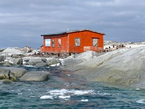 Close to this Argentine naval refuge ( an old corrugated iron shack in rusted colors), lays a simple cross monument, an unreadable metal plaque with just one word “John” recalls the dead of a man of the British Antarctic Survey, who tried to get here over the sea ice in 1982..
 Cape Adare is a prominent cape of black basalt forming the northern tip of the Adare Peninsula and the north-easternmost extremity of Victoria Land, East Antarctica and an important landing site and Base Camp during early Antarctic Exploration.
 Cape Hallett, located 63 miles (101 km) to the South of Cape Adare, is a snow-free area on the northern tip of the Hallett Pensula on the Ross Sea coast of Victoria Land, East Antarctica. he cape was the location of a joint scientific base, Hallett Station, (WAP MNB-08) between the United States and New Zealand during the International Geophisical Year of 1957, and was manned permanently until 1964, when there was a major fire. It was then used as a summer only base until 1973.
  The callsign of Hallett Base (
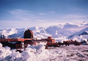 dome that was reportedly used for plant growth as early as 1958 (Image credit: John Cranfield ©Antarctica New Zealand Pictorial Collection [ANZSC0163.2][1961-1962]).
 Members of the Northern Party of Scott’s Terra Nova Expedition over-wintered at Cape Adare in 1911 and 1912. They also erected one hut, which has fallen into ruin today. The remains of two Borchgrevink’s Hut, as well as those of the Terra Nova Expedition’s hut, have also been designated a Histpric Site or Monument (
 After a 19 hours flight, Volker did land at Ushuaia (
 Actually, Volker is embarked on a cruise ship as a lecturer and Tour Guide (no possibility for Radio… ) at an Antarctica expedition. The trip is including Argentina, Chile, South Shetland Islands and Antarctic Peninsula and will last till Feb. 18th, 2023.
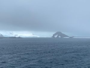 Yesterday, jan 21st, the Polar ship passed near Half Moon Island where the Argentine Summer Station Teniente Camara (
 Nearly 15 years ago, a major restoration project had been taking place at the old abandoned whaling station at Port Jeanne d’Arc. This had been built late in the 19th century by a Norwegian company and abandoned early last century when factory ships made land-based whaling uneconomic. For years the weather and vandalism had been destroying the station, until Jean-François Le Mouël convinced the administration of TAAF that it should be preserved.
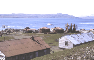 The Kerguelen Islands are located at 49°15′South, 69°35′East. The main island, Grande Terre, originally called Desolation Island, is 6,675 km² and it is surrounded by another 300 smaller islands and islets, forming an archipelago of 7,215 km².
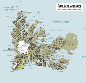 Île du Port, also in the north in the Golfe des Baleiniers at 49°11’South, 69°36’ East, is the third largest satellite island with an area of 43 km² (16.6 mi²); near its center it reaches an altitude of 340 m (1,115 ft.).
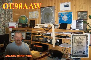 Another 3 entries on the
 After six days of activities on the White Continent, a new version of the Antarctic School Expedition (EAE) organized by the Chilean Antarctic Institute (
 ARA Libertad is a tall ship which serves as a school ship in the Argentine Navy. She was built in the 1950s at the Rio Santiago shipyards near Buenos Aires, Argentina. Her maiden voyage was in 1962, and she continues to be a school ship with yearly instruction voyages for the graduating naval cadets.
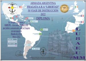
 Master roofer Dimitris Georgiadis (picture aside) will leave for Antarctica in mid-January and will be there until March. He will travel to the icy continent with scientists from Masaryk University in Brno, who are investigating climate change in Antarctica and solving dozens of research projects, including the effect of harsh polar conditions on the human organism.
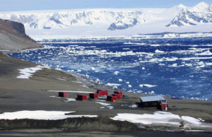
 Petrel Base (
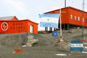 As of November 2022 Petrel became once again a permanent Base. A team of 18 is still there to carry out the necessary works to restore the infrastructure throughout the year. Another goal is to build a 1800 meters main runway and a secondary 1300 meters secondary runway where the Hercules C130 or smaller aircraft can operate. In addition personnel will carry on hydrographic studies to determine the most suitable location for the construction of a dock that will allow operations with shipload.
 cover not only all functional requirements, but also housing requirements in accordance with modern construction techniques.
 To celebrate the 30th Anniversary of Russian Robinson Club (RRC) a Special callsign RI3ØANT will operate from Vostok Base (