Ranui Station (aka North Hut-Ranui lookout hut) located at Port Ross on Auckland Island at 50°32’3Ø” South, 166°15’4Ø” East was maintained by a Team of 4-5 men from 1941 until 3 June, 1945. The first recruits came from the NZ Post & Telegraph Service, but from 1942 scientists were included. Various scientific work took place from wildlife research to detailed meteorological observations. During 1944-45, a survey party led by Flight Commander Allan Eden undertook the first full topographical survey of the Auckland Island group. The complex, included a base hut, ancillary huts, long drops, radio masts, landing areas, and tracks hidden in the rata forest, out of sight from the sea. The hut itself is located
  just below the ridge above the base and provides a clear view of all the entrances to Port Ross. At first, private messages were restricted to bereavement or other urgent matters, but later each man was allowed to send and receive two personal messages annually. The only news of the outside world was that heard over standard domestic radio, and other morse code transmissions picked up by the radio operators.
The remains of the Old Ranui Station is located on the outer reaches of Port Ross, hidden in the back of a small cove.
 ZL9/K8VIR & ZL9DX did operate from Ranui Cove (WAP NZL-Ø9) in the year 1997 …. Maybe it’s time for some others DX-peditionners to try again, isn’t it?
Thanks and credit to: Second World War lookout huts (doc.govt.nz)
A bit more of history;
During the Second World War, the New Zealand War Cabinet were concerned enemy ships might anchor in the subantarctic islands where each harbour could have been a potential refuge for enemy vessels, and actioned the “Cape Expedition”.
The Cape Expedition program was to build three Stations to keep watch for enemy vessels; two on Auckland Island and one on Campbell Island. The coastwatchers were stationed at each for 12 months at a time and were to contact New Zealand by radio if any vessels were seen.  Prefabricated 3m square huts of weatherboard construction with bitumen roofs were shipped to the Auckland Island in 1941. One was built at Port Ross in the North and the other at Carnley Harbour on the South end of the island.
Radio contact was kept to a minimum to avoid detection, and transmissions were largely in morse code. Contact was made with the other stations and the Awarua mainland radio station every 24 hours. This was increased to two plus a weather schedule in 1942, and then four from 1943. If enemy ships were sighted personnel were to alert the mainland by radio, and retreat to emergency huts.
 Radio amateur’s passion is often linked to “Philately”, especially that which recalls the Arctic and Antarctica but also, always in terms of radio contacts, also to the Space as in the case of the International Space Station
  A hobby or a passion?
 travel researcher, postal historian, winner of the “Geographical Oscar”, author of the term “philaturism” presented by “Bottle Mail”, “Traveller’s Mail” and “Polar Mail“, which include postcards, vignette stamps and a special postmark, Valery Ivanovich Sushkov RMØL and students at one of the secondary schools in Ryazan.
 The purpose of the historical-geographical, scientific-educational, film-publishing, tourism-local history and memorial Project “Great Russian Travelers” is the revival of the traditions of Russian travelers in research and discovery, the popularization and promotion of tourism and postal business, highlighting their contribution to the economy of Russian society and the development of ties between the peoples of different countries.
 Thanks to the efforts of the staff actually on Petrel Base (
 We must say that the 1st edition (2004) of the
 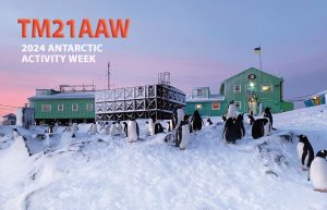 The picture on TM21AAW’s card, shows the Ukranian Antarctic Akademic Vernadsky Station (WAP UKR-Ø1) located at 65˚14′ South, 64˚15′ West, Marina Point on GalindezIsland in the Argentine islands Archipelago. The Faraday British Research base was established there in 1947 and transferred to Ukraine in 1996.
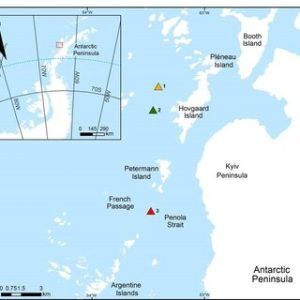 beauty. On those occasions, a “Field Camp” is installed and who knows… maybe one day even an expedition of radio amateurs will give us the pleasure of this “
 has overtaken the original name in usage. The name Krogmann Point has been given to the western extremity of Hovgaard Island.
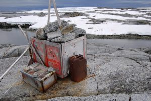 gently sloping smooth rock and snow.
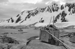 The cache is located up high on weathered stone where it is unlikely to be troubled by snow or ice during the winter. The cache contains emergency supplies for trapped ship-wrecked expedition; inside will be timed food, fire supplies and a tent.
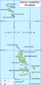
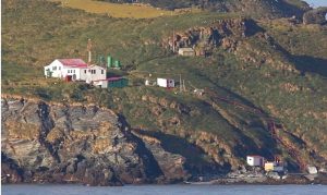 Gonzalo Island (56° 31’ 15” South, 68° 42’ 40” West), is a Sub-Antarctic island, uninhabited except for a Weather and Research Station (
 The important mission of the Diego Ramirez Island Lighthouse
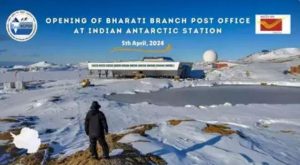 In this historic moment, as a part of the foundation day celebrations, the Indian Postal Services, in collaboration with NCPOR, inaugurated a new Branch Post Office at Bharati Station (
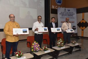 Chief Postmaster General Mumbai, Shri K.K. Sharma, officiated the opening, unveiling a special Picture Postcard of Bharati Station that was released on the occasion with the presence of Shri. R. P. Patil, Director Postal Services, Goa Region, Dr. Thamban Meloth, Director NCPOR, Dr. Rahul Mohan, Group Director and Scientist at NCPOR and the Team leaders of Maitri and Bharati Stations.
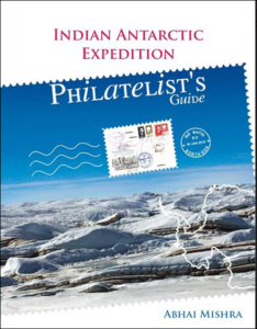 India’s first post office in Antarctica was setup in 1984 at the Dakshin Gangotri Station, which was the country’s first scientific base there, according to a report by Indian Express. Around 10,000 letters and mails had been posted and cancelled at the icy continent’s post office. Significance of post office with Indian address in Antarctica The Antarctica has 2 research stations – Maitri and Bharati – both are a part of the Goa postal division.
 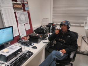 In the list taken from the dedicated Indian philately history of Abhai Mishra’s book (see
 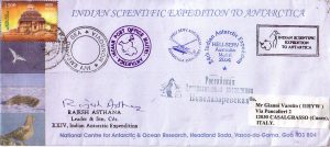 In 1988-89, the Dakshin Gangotri Station (
 Igor is very active on all bands, Actually it’s easy to work him CW on 10 mts as conditions seems to be good on 28 MHz, but also 20 & 40 mts.
 It was a chance with profound symbolic value; losing it would have been a real shame.