 April 5th 2024, INDIA’s NCPOR 24th Foundation Day
India’s National Center for Polar and Ocean Research (NCPOR) did organize an engaging cultural program titled “From Labs to Stage.” This unique event showcased the diverse talents of NCPOR’s scientists and staff, bringing them together in a celebration of creativity and entertainment.
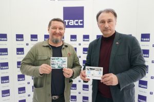
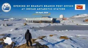 In this historic moment, as a part of the foundation day celebrations, the Indian Postal Services, in collaboration with NCPOR, inaugurated a new Branch Post Office at Bharati Station (WAP IND-Ø4) in Antarctica. April 5 was chosen because it marked the 24th Foundation Day of National Centre for Polar and Ocean Research (NCPOR), Goa.
Dr. Shailendra Saini, group director (Antarctic Operations), said: “This is a symbolic yet milestone effort. Our scientists do have access to modern means of communication including WhatsApp, albeit at slow speeds, so they do keep in contact with their families. But the souvenir value of receiving a letter stamped ‘Antarctica’ in an era when people have stopped writing letters altogether — holds great importance. We will collect the letters once a year and despatch them to our headquarters in Goa from where they will be mailed to the scientists’ families.”
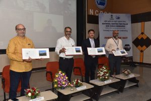 Chief Postmaster General Mumbai, Shri K.K. Sharma, officiated the opening, unveiling a special Picture Postcard of Bharati Station that was released on the occasion with the presence of Shri. R. P. Patil, Director Postal Services, Goa Region, Dr. Thamban Meloth, Director NCPOR, Dr. Rahul Mohan, Group Director and Scientist at NCPOR and the Team leaders of Maitri and Bharati Stations.
K K Sharma said the new venture “underscores the commitment of the postal fraternity to serve even the most remote corners of the globe. The department had earlier installed a post office at Dakshin Gangotri Station in 1984 and another at Maitri Station in 1990. He commended the efforts of all the people involved in making this launch possible and expressed confidence in the postmaster stationed at the Bharati Branch Post Office to facilitate meaningful connections through the exchange of letters with loved ones.
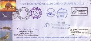
 India’s first post office in Antarctica was setup in 1984 at the Dakshin Gangotri Station, which was the country’s first scientific base there, according to a report by Indian Express. Around 10,000 letters and mails had been posted and cancelled at the icy continent’s post office. Significance of post office with Indian address in Antarctica The Antarctica has 2 research stations – Maitri and Bharati – both are a part of the Goa postal division.
Apart from senior postal department officials, a number of scientists working in Antarctica and was followed by the defacing of the stamps on the postcards by the first Branch Postmaster of Bharati Post Office, Shri. Sudhanshu.
Dr. Thamban Meloth, Director of NCPOR, highlighted the significance of having an Indian Branch Post Office in the icy continent of Antarctica.
Dr. Anand Kumar Singh presided over the function.
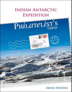
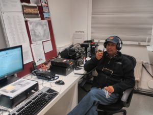 In the list taken from the dedicated Indian philately history of Abhai Mishra’s book (see http://www.waponline.it/antarctic-philately-by-abhay-mishra/). Among the Honorary Post Masters of India’s Antarctic Post Office from the 7th Indian Scientific Expedition to Antarctica (ISEA) through the 32nd ISEA, we found our good friend Bhagwati Prasad Semwal (picture aside) Licensed Ham Radio operator , callsigns: VU3BPZ, Ex-AT10BP, VU3BPZ/P, ex-Antarctican participating the ISEAs XX, XXIV, XXIX and XXXII at Bharati as 8T2BH, who was Post Master himself at Maitri Station.
The first Indian Scientific Expedition to Antarctica was initiated in 1981.
 In 1988-89, the Dakshin Gangotri Station (WAP IND-Ø1) was decommissioned as it was submerged in the continent’s ice and in January 26 1990, a new post office branch was built at the continent’s India Maitri Research Station (WAP IND-Ø3), according to the publication. For over 35 years since then, placed in blank envelopes, letters and postcards were sent to the Maitri station’s post office for cancellation. According to the publication, now, almost 40 years later, the letters which are to be sent to Antarctica, will now be having a new Pin Code – MH-1718.
Read more at: https://www.deccanherald.com/india/significance-of-the-indian-post-office-in-antarctica-with-a-new-pin-code-for-letters-postcards-2968404
TNX and credit NCPOR
 On 7 february 1959 while officially Australia took over operational command, the remaining US personnel at Wilkes did not take kindly to being under Australian control. Consequently there was a compromise until 1961 when the Station came under exclusive Australian National Antarctic Expedition (ANARE) control.
 he’s fighting to achieve a very specific goal: that of obtaining the recognition of Antarctic Specially Protected Area (
 The largest and only independent Italian Antarctic expedition was led by Renato Cepparo in 1976-77 to the South Shetland lslands by the Norwegian ship Rig Mare. It was privately funded and fully self-suffícient. and had the aim of carrying out scientific measurements and leaving a pemanent refuge on the Antarctic Peninsula. Fifteen men, among whom were the deputy leader Flavio Barbiero, a medicai doctor, two divers and four mountaineers who climbed seven peaks on King George Island, were put ashore at King George Island. The geologists Gian Camillo Cortemiglia and Remo Terranova were in charge of the scientific part. Cepparo and his companions landed on King George Island and erected a small building that they named after Giacomo Bove. Today the only remains are the abandoned walls of the station and a wooden table. inscribed by Ing. Admiral Flavio Barbiero. The area stili keeps the name Italia Valley.
 In 2018 in Cervignano del Friuli (Italy), thank to the inexhaustible commitment of Prof. Julius Fabbri (
 In addition a 1:50 scale model of the “Giacomo Bove” Base (
 COMNAP
  The Council of Managers of National Antarctic Programs Annual General Meeting (
 The 46th Antarctic Treaty Consultative Meeting was held with an overarching theme of Tasudhaiva Kutumbakam a Sanskrit phrase which means one Earth, one Family, one Future. This resonates deeply with the Antarctic Treaty System, promoting peace, scientific cooperation. and preservation of Antarctica for mankind.
 45th Antarctic Treaty Consultative Meeting – Twenty-fifth Meeting of the Committee for Environmental Protection. Helsinki, Finland – 29 May 2023 – 8 Jun 2023
 Decisive has been the help of Scott WA4TTK who did provide his QSL of the contact with Jim Collinson W8IJK/KC4.
 Hello Gianni,
  Shackleton Field Camp (aka Shackleton Glacier Camp SHG) is located at 85°05’24” South, 175°19’48” West and lists on WAP-WADA Directory as

 On Tuesday 25th 2024, the New Zealand Hercules flew from Auckland to Christchurch, taking off at 02:00 local time and arriving at Phoenix Airfield (WAP USA-42) in Antarctica at 08:50.
 Concordia Station (
 43 years old, has been selected as station leader of the XX Winter Campaign of the
  Also from the Ukrainian Vernadsky Station (
 On the occasion of this year’s Midwinter Day,
  that have been made in polar science at this time. The
  shared with a new generation keen to learn about Antarctica. We also support other organisations to look after British Antarctic heritage sites in other parts of Antarctica. It is active in the promotion of Antarctic public engagement and supports institutions who have a connection to Antarctic heritage through their collections or education and outreach.
 with all the Antarctic chasers and followers. Thanks to eveyone sharing happyness with us on the Midwinter 2024 by sending us greetings and wishes.


 After suffering from a progressive illness that had recently kept him away from amateur radio, Cosme Alfonso “Pupi” Averna died last june 19 2024 in Ushuaia (
 He was born in Bahía Blanca on July 3, 1948 and at a very young age, he joined the Argentine Navy. In 1984 he was assigned to the Ushuaia Naval Base where he worked in the Weapons Workshop, specializing in ammunition and explosives, retiring after reaching the hierarchy. of Senior Warrant Officer.
 Once he retired from his work activity, he bought a motor home with which he traveled thousands of kilometers throughout Argentina for years, visiting colleagues with whom he had made friends through the radio.
 A good recall of “Pupi” was sent by Volker DL8JDX, a well known Antarctic veteran; Volker said: « I am very sorry about Pupi LU8XP sk. I had the luck to make acquaintance with him in Ushuaia Jan. 28, 2023 …»
 Plateau Station was the highest and most remote scientific station established by the United States. Construction of the site, started on December 13, 1965, and the first Traverse Team (named SPQML II) arrived in early 1966. The station was located at 79° 15’ South, 40° 30’ East in the far interior of the Antarctic ice cap, 11,890 feet above sea level.
 when it was closed but mothballed for future use. Plateau Station was also the coldest of any United States Stations on the Continent and the site for the world’s coldest measured average temperature for a month at that time, recorded in July 1968, at −99.8 °F (−73.2 °C).
 Actually Plateau Station is an inactive American research and support Base on the central Antarctic Plateau.
 In 2017, the CoFi-Expedition made a stop at Plateau Station. They entered the Station through a hatch at the top of highest building, the watch tower. The Bse is completely snowbound nowadays. The only visible building at the base is the meteorological tower. The expedition left the base with the same general impression as the expedition in 2007 did.
 Lion Island 66° 39′ 32″ South, 140° 00′ 53″ East is small rocky island 0.2 mi NNE of Petrel Island in the Geologie Archipelago. It was surveyed and named by the French Antarctic Expedition of 1949-51 under André Liotard. The name derives from the rock summit of the island which has the shape of a lion’s head.
 Pollux Islet a rocky islet in the Pointe-Géologie archipelago (Adelie Land) and Zeus were themselves two rocky islets in the same site; Zeus islet had the bad idea of being located in the axis of this track, between the Pollux islet, 100 mts to the Northwest, and the smallest of the Buffon islands, 100 mts to the southeast. Lamarck Island, a rocky island located 250 mts away to the southeast of Pétrels Island in the fateful NW-SE alignment of Cuvier, Lion and Buffon in the central part of the Pointe-Géologie archipelago, was spared by the construction of the Lion trail.
 On September 21, 1994, the Minister of the Environment Michel Barnier formalized in the Council of Ministers the abandonment of the Adélie land trail.
 HI Folks,
 Not too much to report from Antarctica at this time of the year The White Continent is actually in the deep winter, waiting the 2024-2025 Summer Antarctic Campaign.

 Here below the sites where David did operate from:
 Antarctic Campaign 2022-23
 The “Capitán Estivariz Aeronaval Refuge”, is located on Watkins Island in the Mikkelsen islands group (
 Note:
Note: The Base “Y” at Horseshoe Island (
 VP8DLM operated by Mehdi F5PFP was active from this rare site on March 2011, giving many of the Antarctic hunters a real
  Polish Demay Refuge provide limited accommodation capacity for 4 people with field medical kit available during summer for emergency use. The scientific use, is subject to the permission of the appropriate authority. The refuge (wood hut) is situated on a flat marine gravel terrace in Paradise Cove between Demay Point and Uchatka Point, ca 10 km from Arctowski Station (
 Lions Rump Refuge
  Probably, the old days, those in which CW and SSB were the best expression of the world of Amateur Radio will never come back, but fortunately, there are still young people that, to the most modern digital transmission/reception techniques (such as FT4/FT8, in which is the PC that makes QSOs), those youngs prefere the traditional ways, those that truly have the charm that takes you inside!
 website: “I relive good memories as I read her lines, emotions arise and fingers frozen too” was his comment!
 Petrel Base opened in 1967 but has been used as a temporary summer base since 1976, after a fire destroyed its main accommodation building. Petrel Base (
 The New Petrel structure took into account all the technological innovations of recent decades and all the scientific knowledge about the climatic and geographical conditions of Antarctica that was produced at this time. We also studied the projects of Countries that built Antarctic bases in recent years.
 Ranui Station (aka North Hut-Ranui lookout hut) located at Port Ross on Auckland Island at 50°32’3Ø” South, 166°15’4Ø” East was maintained by a Team of 4-5 men from 1941 until 3 June, 1945. The first recruits came from the NZ Post & Telegraph Service, but from 1942 scientists were included. Various scientific work took place from wildlife research to detailed meteorological observations. During 1944-45, a survey party led by Flight Commander Allan Eden undertook the first full topographical survey of the Auckland Island group. The complex, included a base hut, ancillary huts, long drops, radio masts, landing areas, and tracks hidden in the rata forest, out of sight from the sea. The hut itself is located
  just below the ridge above the base and provides a clear view of all the entrances to Port Ross. At first, private messages were restricted to bereavement or other urgent matters, but later each man was allowed to send and receive two personal messages annually. The only news of the outside world was that heard over standard domestic radio, and other morse code transmissions picked up by the radio operators.
 ZL9/K8VIR & ZL9DX did operate from Ranui Cove (WAP NZL-Ø9) in the year 1997 …. Maybe it’s time for some others DX-peditionners to try again, isn’t it?
 Prefabricated 3m square huts of weatherboard construction with bitumen roofs were shipped to the Auckland Island in 1941. One was built at Port Ross in the North and the other at Carnley Harbour on the South end of the island.
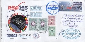 Radio amateur’s passion is often linked to “Philately”, especially that which recalls the Arctic and Antarctica but also, always in terms of radio contacts, also to the Space as in the case of the International Space Station
  A hobby or a passion?
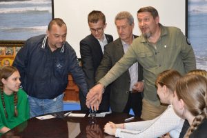 travel researcher, postal historian, winner of the “Geographical Oscar”, author of the term “philaturism” presented by “Bottle Mail”, “Traveller’s Mail” and “Polar Mail“, which include postcards, vignette stamps and a special postmark, Valery Ivanovich Sushkov RMØL and students at one of the secondary schools in Ryazan.
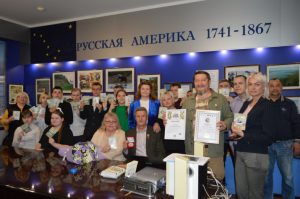 The purpose of the historical-geographical, scientific-educational, film-publishing, tourism-local history and memorial Project “Great Russian Travelers” is the revival of the traditions of Russian travelers in research and discovery, the popularization and promotion of tourism and postal business, highlighting their contribution to the economy of Russian society and the development of ties between the peoples of different countries.
 We must say that the 1st edition (2004) of the
 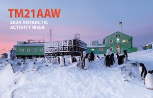 The picture on TM21AAW’s card, shows the Ukranian Antarctic Akademic Vernadsky Station (WAP UKR-Ø1) located at 65˚14′ South, 64˚15′ West, Marina Point on GalindezIsland in the Argentine islands Archipelago. The Faraday British Research base was established there in 1947 and transferred to Ukraine in 1996.
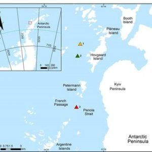 beauty. On those occasions, a “Field Camp” is installed and who knows… maybe one day even an expedition of radio amateurs will give us the pleasure of this “
 has overtaken the original name in usage. The name Krogmann Point has been given to the western extremity of Hovgaard Island.
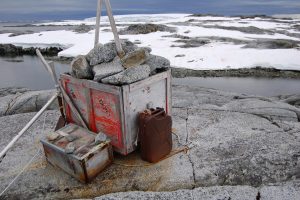 gently sloping smooth rock and snow.
 The cache is located up high on weathered stone where it is unlikely to be troubled by snow or ice during the winter. The cache contains emergency supplies for trapped ship-wrecked expedition; inside will be timed food, fire supplies and a tent.
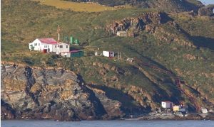 Gonzalo Island (56° 31’ 15” South, 68° 42’ 40” West), is a Sub-Antarctic island, uninhabited except for a Weather and Research Station (
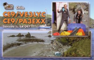
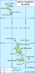 The important mission of the Diego Ramirez Island Lighthouse
 Igor is very active on all bands, Actually it’s easy to work him CW on 10 mts as conditions seems to be good on 28 MHz, but also 20 & 40 mts.
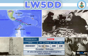 It was a chance with profound symbolic value; losing it would have been a real shame.
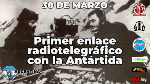 when the sounds of the Morse alphabet were heard for the first time in Antarctica; fundamental step in the development of communications at those latitudes, That day at the Meteorological Observatory of the South Orkney Islands, the Orkney Station (LRT) was officially inaugurated.
 When on that historic day, March 30, 1927, the Morse sounds of the letters were heard and repeated at rhythmic intervals: “LRT… LRT…”, everyone shouted in unison “We… We… Finally …Finally…”, the question was: Who is calling us? and immediately you could hear “LRT… LRT… de LIK… LIK… LIK…”; exclaiming all together “They’re calling us from Ushuaia.”
 Ham Radio is something of incredibile!
 Valery Sushkov RMØL (ex RW3GW) is a travel researcher, postal historian, travel marketer, documentarian, chief postmaster of the International Philaturism Society, author of the new concept of “philaturism” in the history of world tourism practice, curator of the World Postal Mail Museum. Head of the Project “POSTVENTURE & Postal Adventure”. Visited more than 50 countries of the world, participant and organizer of more than 100 different expeditions on 6 continents, conqueror of the South
 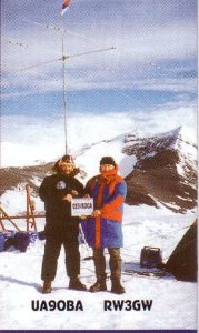 Pole and the highest peak in Africa – Mount Kilimanjaro, member of the Russian Geographical Society – Society for the Study of the Amur Region, member of the Union of Journalists of Russia, laureate and winner of the National Awards of the Russian Geographical Society “Crystal Compass”.
 Philaturism is educational and adventure tourism and the study of territories through the prism of philately and postal history, something new born from the fervent mondo f Valery!.
 It’s a real shame! Six people visited Platcha Hut, a brand “New One” for many Antarctic Hunters, and nobody brought an HF Radio, to operate a little while from there, and living us the pleasure to log a rare spot in Antarctica!
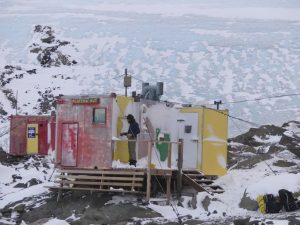 Platcha Hut 68° 30′ 47″ South, 78° 30′ 36″ East is situated in an extemely handy spot at the base of the plateau just to the south of Breid Basin a few metres above the shoreline. The locale is easy to reach by helicopter in the summer and is a decent walk over rough terrain from Davis Station for the keen. In the winter, Platcha Hut is one of the first to be visited once the sea ice forms and is thick enough. From Davis quads or Hägglunds, head along a waypointed route that follows Long Fjord to Breid Basin. The Hut itself sleeps four in bunk beds with room for two in the recently renovated (2011) Met Hut (the original Platcha) at the back.
 The present Platcha Hut was built in 1982. On the 9th of September the internal fit-out was transported to Platcha and by the 16th of September the hut was completed and ready for occupation which was a mammoth effort by the wintering team of 1982.
 Luis Risopatrón Refuge is an Antarctic Chilean refuge, located at 60°22’17” South, 59°42’53” West on the north shore of Coppermine Cove, Robert Island in Nelson Strait on South Shetland Islands
 Risopatrón, although, due to its characteristics it was known for quite a bit of time, as Luis Risopatrón Refuge. The shelter is located 40 m above sea level, on a solid rock surface, 150 m from the coast. 20 km from the closest base, Captain Arturo Prat, (
 Antarctic Base, which did participate in the activities of the International Geophysical Year on March 3, 1957. This Base was set 60 meters from the O’Higgins Base (
 Last march 10th 2024, the marathon for the “120th Anniversary” of Argentina’s presence in
  All Digital Certificates, available to those who did work the Argentina’s Bases in Antartica and other official LU station which work within the event, could download their own confirmation by entering the QSLOG.AR website at:
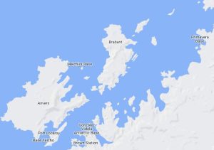 Brabant Island, lying off the west coast of the Antarctic Peninsula at 64°15’South, 62°20’West, is the second largest Island of the Palmer Archipelago within the British Antarctic Territory. Brabant Island, 59 km (37 mi) long north-south, 30 km (19 mi) wide, is lying between Anvers Island and Liège island. It had only been visited on six very brief occasions since its discovery in 1898, although a 1/200 000 topographic map had been produced in 1963 from FIDASE aerial photography.
 As widely announced, last month of February, the 21st edition of the
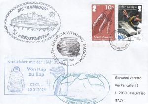
 Exhibits include discovery, exploration, Shackleton, surveying and mountaineering expeditions, sealing in the late 18th and early 19th centuries, the early days of whaling, techniques of modern whaling in the middle part of the 20th century, whalers’ social life, maritime history, and natural history. Displays also cover the 1982 conflict and subsequent British military presence until 2001.
 GSGSSI has responsibility for the operational buildings and infra-structure associated with the museum. The
  A press conference, a special post card cancellation ceremony, and a presentation of a quest route was held in Moscow in honor of the 90th Anniversary of the heroic epic of the rescue of the Chelyuskints and the establishment of the title of Hero of the Soviet Union.
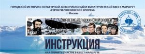
 At the end of the press conference, a solemn ceremony of special cancellation of a special postal card and a stamp with a limited edition and a presentation of the city memorial, historical, cultural and philaturist quest route in Moscow, took place.
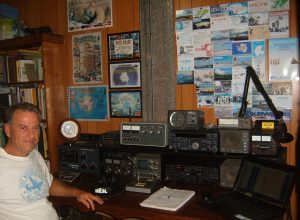 John (SK), formerly VK2FR and VK2ANT, was a skilled radio Ham that spoke to many people around the world including those at Antarctic Bases and research stations over the last four decades.
 Aimee Sharpe wrote
 The WAP
 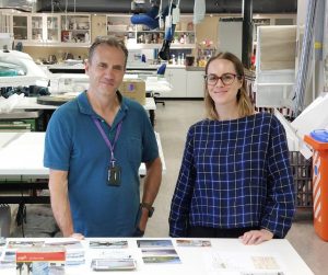 The
The 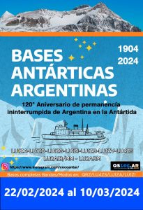 Beside the WAP’s Antarctic Activity Week which runs from
  Date:
Date: Wilkins Aerodrome at 66°41’27″South, 111°31’35″East is named after the legendary patron and pioneer of early Antarctic aviation, Sir Hubert Wilkins.
 ensure that the surface ice has suitable bearing strength and integrity to support the aircraft.
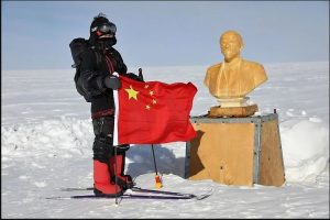 Chinese explorer and adventurer, Feng Jing, hiked to the Southern Pole of Inaccessibility (
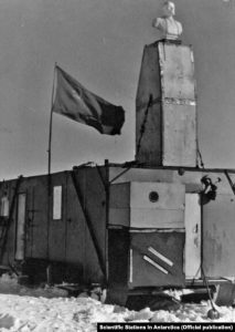 The station had a hut for four people, a radio shack, and an electrical hut. These buildings had been constructed on the tractors used during the traverse, serving as accommodation. On top of the camp structures, they placed the Lenin bust. Next to the hut, an airstrip was cleared and a Li-2 aircraft landed there on 18 December 1958. The outpost was equipped with a diesel power generator and a transmitter. Pole of Inaccessibility Station performed meteorological observations from 14 to 26 December 1958.
 The 8th Soviet Antarctic Expedition visited the site on 1 February 1964 and left five days later.
 February 10, 11 and 12, 2024, the Argentine Ship Fragata ARA Libertad will be on air for 3 days. It will be a chance, an opportunity not to be missed!
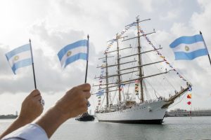 Argentine and Foreign Amateur Radio Stations will be able to download their QSL by entering the QSLOG.AR integrated system, through the website
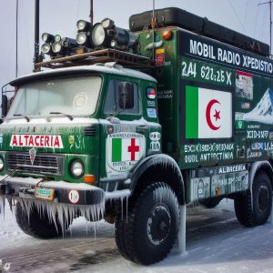
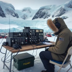 Kamel Ghalem, 7X2GK will participate in the 21st Antarctic Activity Week with the special callsign: 7T22ANT (
 An interesting article published at:
  Horký, a traveller and documentary filmmaker, as well as an experienced polar explorer who has made expeditions to the three poles of the Earth (North, South and the Cold Pole), and Jan Šimánek, a cameraman. They will be shooting a unique documentary about the Czech Antarctic Research Programme for Czech Television.
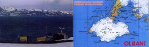 (
(
 On 23 January 1954, Argentine Navy personnel did inaugurate the Cabo Primavera Refuge (now Capitán Cobbett Naval Refuge) on a rocky promontory on Cape Primavera. Over many years this building was used by Argentine exploration expeditions to the area to collect Meteorology and Biology data.
 Eric sent us a preview of the new QSL of TM1ANT expressly designed for the 2024’s AAW .
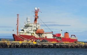
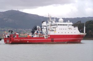 The Oceanographic Vessel (B/O) Sarmiento de Gamboa is a multidisciplinary research vessel with a global non-polar scope. Its instrumentation and laboratories allow it to carry out studies of global ocean circulation, marine biodiversity, fishery resources and climate change; It is also used to perform work in geology, marine geophysics, hydrography, physical and chemical oceanography, marine biology, resource estimation (fisheries), ocean monitoring with remotely operated vehicles (ROVs, AUVs, submarines, etc.), and deployment of underwater observatories (OBSEA, GEOSTAR)
 It also has the most advanced technologies in terms of navigation systems (for example, dynamic positioning) and is the first Spanish oceanographic vessel that can work with high-depth ROVs (Remote Operated Vehicles) and AUVs (Autonomous Underwater Vehicle).
 Kottas camp (74°12′ South, 9°44′ West) is a German Field Camp at Dronning Maud Land, Antarctica has been add to
 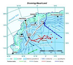 The 460km long stake line comprises approximately 950 stakes . It starts 10 km South of Neumayes at 70°41.83’ South, 8°26’24” West and ends after the crossing of Kottasberge at 74° 30’00” South, 9°13,09’ West.
 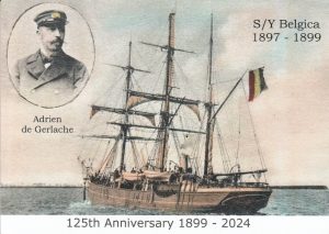 The Belgian Antarctic Expedition of 1897–1899 was the first expedition to winter in the Antarctic region. Led by Adrien de Gerlache de Gomery, it was the first Belgian Antarctic expedition and is considered the first expedition of the Heroic Age of Antarctic Exploration. Among its members were Frederick Cook and Roald Amundsen, explorers who would later attempt the respective conquests of the North and South Poles.
 S/Y Belgica did remain trapped in the ice for a long Antarctic winter.
 Edgeworth David Fied Camp (aka Edgeworth David Base) was established as a summer camp in 1986. Located at 66°14’59” South, 100°36’12” East , in the Northen Bunger Hills, Edgeworth David summer Base lies about 7 kilometres (4.3 mi) from WNW of Polish Antoni Dobrowolski Station (
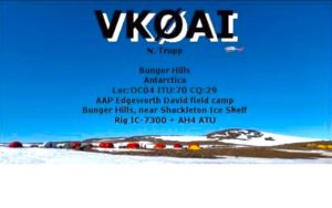 Edgeworth David Field Camp has been
 The twenty third edition (release 1.43) of
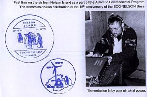
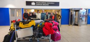 Few days ago, the Czech members of the Antarctic Expedition to Nelson Island were in Punta Arenas, Chile, waiting for a Brazilian ship to take them to their destination. That morning the host of
 Antarctic Program, which will set sail this afternoon Jan 2nd 2024, heading Antarctica.