The Netherlands in Antarctica: Dirck Gerritsz Laboratory (WAP NLD-NEW)

Dutch Ministry of Education, Culture and Science took the decision in 2010 to make the sum of six million euro available for research in Antarctica. On Sunday 27 January 2013, the Netherlands Organization for Scientific Research (NWO) opened the first Dutch Laboratory in Antarctica and it  has been placed near the British Rothera Research Station.

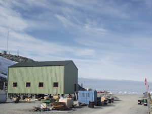
The lab is named after the sixteenth-century Dutch merchant, Dirck Gerritsz, probably the discoverer of Antarctica. The Dirck Gerritsz Laboratory (WAP NLD–NEW) consists of four sea containers that have been converted into laboratories and placed in a docking station.

In the laboratory Dutch scientists carry out research into Algae, Traces of iron in the warming Antarctic seawater, Freshwater flow 
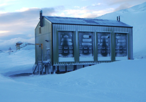
and climate change on the Antarctic Peninsula, study the  influence of glacier melt water on marine microbial communities in Ryder Bay and  Greenhouse gases.

The Netherlands is a signatory to the Antarctic Treaty and this is the reason behind the Netherlands’ Polar research program.

The South Pole is a unique research environment where the consequences of climate change can be measured in detail, without any human disruptions. The first five research projects did start at the Dirck Gerritsz Laboratory in the Antarctic summer of 2012-2013.


At the light of this evidence, the Dirck Gerritsz Laboratory Lat. 67°35’8″S, Long. 68°7’59″W  on Adelaide Island, will be add to the WAP-WADA Directory (next issue

Dutch Gerritsz Lab

Jan. 2018) under WAP NLD-NEW.


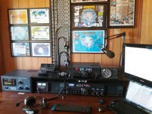
As soon as some Hams will be active HF from there, a WAP reference will be issue.

VU3LBP/P Bharati Research Station WAP IND-Ø4

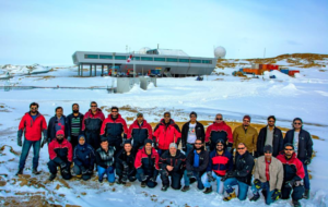
The 36th ISEA Team (Indian Scientific Expedition to Antarctica) at Bharati Station is almost at the end of its overwintering task, after a successful winter at 69° 24’ 28” South, 76° 11’ 14” East.

Snow is melting up and the austral summer is slowly coming.
(Picture aside,  taken by Abhijeet Jadhav)

Mr. Rajesh Dabral  (VU3LBP) who did replace  Bhagwati Prasad (VU3BPZ-8T2BH) as Communication Officer at the Base, is trying to be QRV mostly on 20 mts band.

In the last couple of days he made several contacts with VKs, ZLs and ZSs 
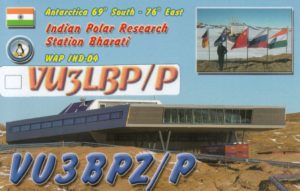
but still no Europeans on his log.

Raj, who is signing VU3BPZ/P is normally on 14.183 MHz +/- QRM  in the morning from 05:00 UTC and ahead.

Two more months before  he leaves and returning back home so two more months … last chance to work him at Bharati Research Station, Antarctica.


Let’s hope propagation can improve a bit otherwise it will be hard for EU to work VU3BPZ/P.

Port Lockroy WAP GBR-Ø1 (a UK Antarctic Heritage)

 Port Lockroy, Base ‘A’ (WAP GBR-Ø1) , is a British historic Base situated on Goudier Island off the Antarctic Peninsula.

It was established in 1944 and operated as a British Research Station until it closed in 1962. The abandoned Base was designated a Historic Site and Monument under the Antarctic Treaty and in 1996 restored as a  “living’ museum”.

Base A now welcomes visitors to the site every Austral summer, in order to promote the work of the UKAHT on the Peninsula and in the UK and to give visitors a taste of base life from the early days of British occupation.

It is visited each Austral summer by approximately 18,000 ship-borne visitors, amounting to one to two ship visits per day.

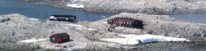
In the photos you can see the three buildings at Port Lockroy: Bransfield House, the Boat Shed and the Nissen Hut. In the distance you can also see the anemometer tower as well as the antenna mast (in 1957 Port Lockroy used to have eight antenna masts which were used for high frequency radio communication).

Read more at: http://www.ukaht.org/discover/port-lockroy/ 


Davis Station Airdrop

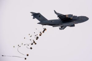
In a first for the Australian Antarctic Program, nine tonnes of cargo was parachuted from the back of a Royal Australian Airforce C-17A Globemaster III and on to the sea ice near Davis Research Station (WAP AUS-Ø3) on Sept.20-2017

The C-17A was refuelled by a KC-30A Multi-Role Tanker Transport – high above the Southern Ocean – half-way through the 10,000km round trip mission.

The cargo was predominately food based, including fresh lemons and carrots, and also included medical supplies and telecommunications equipment. The pallets were ripped by the Australian Army’s 176 Air Dispatch Squadron.

photos were captured from the sea ice by Barry Becker.

Source: http://www.antarctica.gov.au/news/2017/mid-air-refuel-extends-reach-of-australian-antarctic-program#v208710
There is a nice video at the bottom of the article, don’t  miss it!

Other videos provided by Australian Antarctic Division are available here:


VK2FR … one of the Antarctic chasers

John S. Sharpe, VK2FR from Bowraville, NSW , Australia, is one of the very active Antarctic chasers. John is also active during the Antarctic Activity Weeks as VK2ANT  (WAP-232) and a proud owner of the WAP Awards including the Honor Roll, as shown on the wall of his shack!

John, who seems to have enjoyed the new look of the WAP website,  wrote: Greetings to the Antarcticians  from New South Wales.  Congratulations to you and staff for a fantastic job with the new WAP web site, it looks terrific!.   Please count me in for 15th AAW!

Many thanks John, and  welcome on board again , you will be add to the list of participants  of next AAW 2018.


To the Hams readers: it’s time to apply for your special call and join the next 15th AAW,  from 17 to 25 Febr. 2018.


Enjoy Antarctica as much as we do!

14th WAP Meeting-Mondovì Italy-16 & 17 Sept.2017

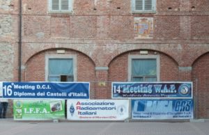
Great time this morning at the  14th WAP Meeting managed by ARI section of Mondovì in the North West side of Italy, not too far away the French border. Held in the frame of Vicoforte, a wonderful site at the foot of the Alpes, we were inside an architectural gem just aside the Vicoforte Basilica, known for having the largest elliptical cupola in the world.

(Read more at:  https://it.wikipedia.org/wiki/Santuario_di_Vicoforte )

Clik the gif  aside to see a video

Over here we did talk about DX, Italian Castles and Antarctica.  Nearly 40  years of Antarctic passion  … 40 years of continuous work is a long time,  and undoubtedly  this is a great goal.

(on the 2nd pic aside, L to R:  the President of ARI Mondovì IW1EVQ Prof. Edo Ambrassa, IK1GPG Max, I1HYW Gianni).
This year,  on the lecture, we have officially presented WAP 2.Ø our brand new looking Web site fully dedicate to Antarctica; presentation has been done by  Gianni I1HYW and Massimo IK1GPG. Guests from almost all the Italian call areas, and Hams from some EU Countries..


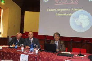
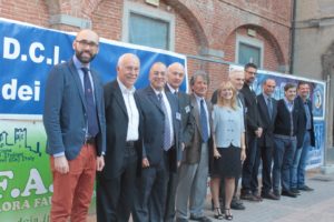
Authorities present: Luca Robaldo,  Councilor of  Mondovi City, Dr. Marco Botto President of an  important local Company, Graziano Sartori, ARI Vice President.


At the end of the meeting,   the restaurant of the ancient Cistercian monastery hosted the participants

Swedish Kirvanveggen Camp – Antarctica WAP SWE-Ø1

Kirvanveggen Camp is listed on our WAP-WADA Directory and it was activated by Radio amateur (Callsign 7S8AAA) in the 90ties.

We did involved the Polarforskningssekretariatet in Sweden, to know if they could have archived some more information.
The answer from Ida Edlund, Registrator, Administrativ handläggare/Registry Clerk, Administration Officer at  Polarforskningssekretariatet/Swedish Polar Research Secretariat, P.O. Box 50003, SE-104 05 Stockholm, Sweden (ida.edlund@polar.sewww.polar.se ) was prompt and kind: -We believe that what you are referring to may be a temporary camp from a project in the 1990’s. However there is no Swedish camp there anymore and we unfortunately do not have any more information about this-.

Swedish Antarctic Research Program (SWEDARP) was assigned the call 7S8AAA, and early in 1988 a group of 12 geology researchers spent a few months in the Antarctic. Kent SM7DSE, a University of Lund professor, was the one who made amateur radio a part of the expedition. He planned to work CW, SSB. RTTY, AMTOR, and HF Packet. QSL cards was requested to be sent via SK0MT, Club Taby Sandaramatorer.
Looks like that, Swedish Kirvanveggen Camp – Antarctica was set close to the site where  the Swedish SVEA Base, was built during the 1987/88 expedition. 

Once again Ida Edlund wrote: -After your previous mail with the picture, we started to look at the research expeditions from the late 1980’s (instead of the 1990’s) and found that Kent Larsson, of the University of Lund, was one of the participants in the 1988/89 expedition at Vestfjella and Heimefrontfjella, close to Kirvanveggen. Kent is a radio amateur and now I see that you already have that information. Kent Larsson is still affiliated with Lund University as Professor emeritus.

His contact information is available here: http://portal.research.lu.se/portal/en/persons/kent-larsson(a62088e5-db40-4c9a-a88a-c78cb023119c).html

We are now trying  to get in  touch with Prof. Kent Larsson (Ham call SM7DSE) to ask him if he did keep some pictures of the camp and eventually if he can send some personal memories of the time been down there at  Kirvanveggen Camp let’s see …

Stay tuned and follow us. WAP is always on the front line of the Antarctic matters.

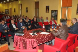
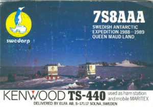
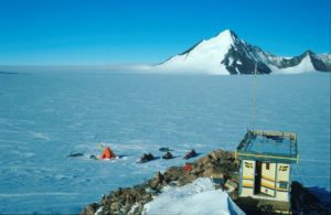
Just few notes about SVEA (WAP SVE-Ø2)
Svea is located in the Scharffenbergbotnen valley in the Heimefrontfjella mountain range, about 400 km from the coast. It was built during the 1987/88 Antarctic expedition and was the first Swedish research station in Antarctica since the Snow Hill station in 1901 and Maudheim in 1949.

Svea is a satellite station to Wasa and is an excellent base for small, transient research teams performing fieldwork in the area. The station, comprising two joined fibreglass modules, is about 12 m2 and has four beds and one pantry.

The station is currently the home base for two permanent monitoring projects: continual geodetic measurement using GPS technology, run by the Royal Institute of Technology in Stockholm, and a seismograph that records movements in the earth’s crust, run by the German Alfred Wegener Institute.

Belgian King Baudouin Base WAP BEL-Ø1

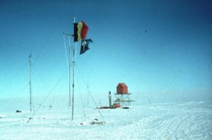
The third International Polar Year of 1958-1959 heralded the second important phase of the Belgian presence in Antarctica. This year was also known as the International Geophysical Year (IGY), in which not less than sixty-four nations signalled their commitment to study the physical characteristics of the earth.

In that period a massive scientific offensive was launched in all the unexplored areas of the planet. And, because hardly any real, systematic scientific observation had been done in the Antarctic, the South Pole became one of the central objectives.

Twelve nations – of which Belgium – decided to establish more than fifty bases on the Pole with the principle aim of studying our planet’s relationship with the sun. The Americans built the Amundsen-Scott Base at its theoretically most important point : the geographical South Pole, t
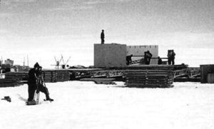
he Russians set up their Vostok Base at its least accessible point, the middle of the East-Antarctic icecap.

On  the initiative of Adrien de Gerlache’s son Gaston de Gerlache (captain of the 1897-1899 ‘Belgica’ expedition), the Belgians confirmed their scientific interest in the continent by establishing the King Baudouin Base on a floating ice shelf off the coast of Dronning Maud Land.  The Belgian base, established in 1958 by the 1958 Belgian Antarctic Expedition under Gaston de Gerlache was named for Baudouin, King of the Belgians from 1951-1993.

It was built at 70° 25′ South,  24°19′ East  on an ice shelf south of Breid Bay on Princess Ragnhild Coast.  King Baudouin B
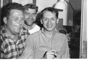
ase  has been reconstructed in 1964 and closed in February 1967.

A new station  Princess Elisabeth Station (WAP BEL-Ø2) is now the only Belgian Research Base in Antarctica

Actually King Baudouin Base  is fully covered in the snow, but thanks to Roger Vanmarcke, ON4TX who kindly sent us some pics of the Belgian epic, we have some very rare images to share with the readers.

Roger Vanmarcke, ON4TX- OR4TX (here in the pic aside /MM with ON4KR-OR4KR and ON4TZ-OR4TZ) is now 80 and he was one of the seven operators who have alternated their presence in Antarctica  and being active from King Baudouin Base  from 1958 through 1968 (they 
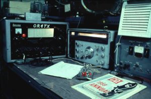
were: OR4KR, OR4OR, OR4RW, OR4TX, OR4TZ, OR4VN and OR5RK).

During the first expedition OR4HG was also QRV; OR4HG was ON4HG, Gene Hoogewys, who wrote a book about the Expedition:

Op de golven van het gevaar” in Dutch, or  “Par delà les ondes” in French.

Here aside the Shack at King Baudouin Base (1959-1960) .

Furthermore, Roger recalls – while he was at the base- that  there was an Italian scientific Team of the Pisa University. They have been drilling more then 100m deep in the ice.This was in cooperation with Professor Picciotto of the ULB (Université Libre de Bruxelles).

Full information here:

https://www.igsoc.org/journal/4/31/igs_journal_vol04_issue031_pg101-110.pdf


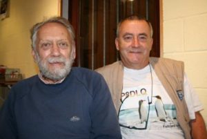
Our good friend Ghis ON5NT, went to see ON4TX/OR4TX personally  at his Radioclub in Waterloo, near Brussels and Roger was extremely kind to give him the reminds that are part of his life. Pictures are from the 1960 Belgian expedition. (pic on the right: Roger ON4TX and Ghis ON5NT)


We are so grateful to Roger Vanmarcke, ON4TX- OR4TX to share his huge recalls with the Antarctic chasers through WAP.

HFØARC Henryk Arctowski Station, WAP POL-Ø1

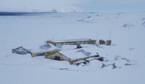
On the last 3 weeks Sebastian Gleich, SQ1SGB has been reported active from the  Polish Antarctic Station Henryk  Arctowski  (WAP POL-Ø1) as HFØARC on 20 & 40 mts.

HFØARC it’s a new call sign  issued in place of the old historical HFØPOL that, until March 2016, was associated with the Polish Arctowski Antarctic Base.


HF0POL’s  operators have been  active during various campaigns and winter expeditions. Here below  is a list of such operations with years of activity, operators callsigns and  QSL managers :


1978: op. LA2HFA, ex SP2BHZ, via SP2BBD (SK) (unknown status)

1986, February: via SP5EKZ or SP5PWK

1988-1989: op. SP3FRV via SP3FXG

1989-1990: op. SP5FLC via SP5FLC (SK)

1990, May: via AE5CK, ex KB6GWX

1990-1991: op. SP3FYM via SP3HLM

1991-1992: op. SP9DWT via SP9DWT

1997: op. SP3GVX via SP3FYM (hardly possible to receive a card)

1998: op. SP3BGD via SP3BGD, direct only (e-qsl & LotW), see SP3BGD at QRZ.com

2000: ops. SP3GVX & SQ5EWQ via SP3WVL, direct only. Log uploaded to e-QSL.

2002: op. SP7JKW, direct only to SP7JKW (See QRZ.com)

2004: op. SP2GOW via SP2GOW, direct only, see QRZ.com

2004, 3/4 April: op. SP5QF via SP7IWA, direct only, see SP7IWA’s website

2005: op. SP3GVX via SP3WVL, direct only

2008: op. SP3GVX via SP3WVL, direct only

2008: HF0POL/LH, op. SP3GVX via SP3WVL, direct only. Lighthouse WAP POL-LH-001

2008 – 2009 op. Janusz SP9YI (XXXIII Polish Arctic Expedition) , QSL direct only via SP9YI


Sebastian SQ1SGB will end his overwintering contract next October 23rd 2017,  so one more month and a half to try to put him in the Log. He’s  working  with a Delta Mini antenna sponsored by SP1BKS

QSL cards direct only to:

Sebastian Gleich,

76-039 Biesiekierz 65 

Poland

Phoenix Airfield Antarctica  (WAP USA-NEW)

Phoenix Airfield (ICAO: NZFX) 77°57’23″South, 166°46’00″East did  start to be operational last February 2017. This compacted 
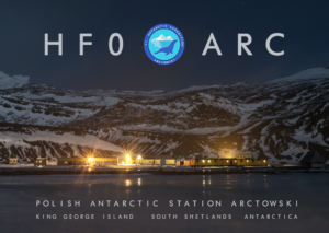
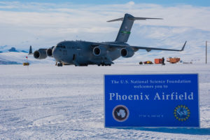
snow runway (WAP USA-NEW) has replaced Pegasus Field  (WAP USA-42).  This runway is capable of handling wheeled aircraft, that have included to date: Lockheed C-5 Galaxy, Lockheed C-141 Starlifter, Boeing C-17 Globemaster III, Lockheed C-130 Hercules and Lockheed P-3 Orion.


The other runways in the area are :

The Ice Runway (ICAO: NZIR (Mc Murdo Aerodrome, Airfield  Airport)

77° 51’ 14”South, 166° 28’ 08” East. Ice Runway is the principal runway for the US Antarctic Program during the summer Antarctic field season due to its proximity to McMurdo Station (WAP USA-22).


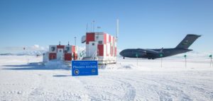
Ex Pegasus Field Runway (ICAO: NZPG) WAP USA-42

77°57’48″South   166°31’29″East was an airstrip in Antarctica, the southernmost of three airfields serving Mc Murdo Station. It closed due to excessive melting in the summer season caused by warmer temperatures combined with dust and dirt blown in from nearby Black Island. The last flight was on December 8, 2016

In the early 1990’s, the Pegasus Airfield was seen as the facility that would facilitate all-season wheeled aircraft operations at McMurdo. That was the 
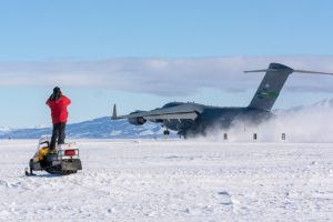
promise…it was developed originally as a “blue ice” runway (meaning that it consisted of long-term ice that was neither accumulating nor ablating). That condition is more actually applied to colder land-based inland locations such as Patriot Hills, rather than a warmer location on shelf ice.

Development of Pegasus took place in the early 1990s, near a site which had formerly been used/known as Outer Williams Field. Construction started in 1991-92, the following year an initial 6,000-foot runway was used by wheeled C-130’s, and in January 1994 it was certified for use by C-141 aircraft (early history and links). Initially the runway was only used at the end of the austral summer seasons and was then allowed to accumulate snow cover which would preserve it through much of the following summer season until it was reactivated. Although Pegasus was originally conceived as part of a “blue ice runway” survey, it actually came to be more properly known as a “white ice runway” as the base was not a permanent glacier, but rather a 100-foot-thick permanent sea ice shelf. The surface came to be maintained with a perhaps 5-inch layer of processed and leveled snow.


Williams Field (NZWD) WAP USA-25

77°52’02″South, 167°03’24″East is the principal runway for the US Antarctic Program during the summer Antarctic field season due to its proximity to McMurdo Station. It is actually inactive but maintained as a backup for ski-equipped aircraft.. In 2008-09 the program switched from using 3 airfields; the annual Ice runway (Mc Murdo Station) in early season, Williams Field for ski aircraft, and Pegasus in late season.

Source: http://www.southpolestation.com/mcm/1617/phoenix.html