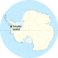
 Smyley Island is an Antarctic island lying off the Antarctic Peninsula at coordinates (72°55′South, 78°0′West). The island is 61 km (38 mi) long and from 13 to 34 km (8 to 21 mi) wide and lies about 20 kilometers (12.4 miles) north of Case Island and the island connects to the Stange Ice Shelf. Smyley island is one of the 27 islands of Palmer Land, Antarctica and is separated from Alexander Island by the Ronne Entrance.
In 1939–1941 Smyley Island was first identified as a peninsula of mainland Antarctica by the United States Antarctic Service and was named Cape Smyley. In 1968 it was identified as an island on a U.S. Geological Survey map. The island is named after Captain William H. Smyley, the American master of the sealing vessel Ohio during 1841–42
A 497, a site on fast ice near Scorseby Head, on the northern shore of the island, has been designated an Important Bird Area (IBA) by BirdLife International because it supports a breeding colony of some 6,000 emperor penguins, based on 2009 satellite imagery.
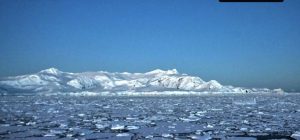 A catastrophic die-off of emperor penguin chicks has been observed in the Antarctic, with up to 10,000 young birds estimated to have been killed. The event, in late 2022, occurred in the west of the continent in an area fronting on to the Bellingshausen Sea.
The sea-ice underneath the chicks melted and broke apart before they could develop the waterproof feathers needed to swim in the ocean. The birds most likely drowned or froze to death.
Dr Peter Fretwell, from the British Antarctic Survey (BAS), said the wipeout was a harbinger of things to come. The scientists tracked five colonies in the Bellingshausen Sea sector – at Rothschild Island, Verdi Inlet, Smyley Island (picture above), Bryan Peninsula and Pfrogner Point.
Read more at: Climate change: Thousands of penguins die in Antarctic ice breakup – BBC News