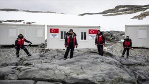
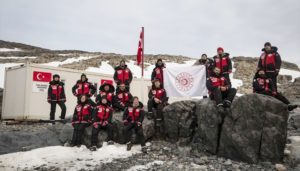
 Turkish scientists continue their scientific research on Horseshoe Island in Antarctica. After the construction of Turkey’s first temporary science Base on the island (67°49’40” South, 67°12’08” West), the Team welcomed a group of guests from Chile, Bulgaria, the Czech Republic and Ukraine for the first time. The six guest scientists did work together with the 24-member of the Turkish research Team joins 15 scientific projects in the Earth, life, and marine sciences.
In addition, Turkey has opened GNSS station on Dismal Island, at 73 kilometres (45 miles) from Horseshoe Island in Antarctica, to track changes in the location of icebergs and transmit photos of Antarctica’s surface, as well as process data from GPS, GLONASS and Galileo.
 “The GNSS satellite navigation base station was set up within the framework of the fourth Turkish scientific expedition to Antarctica” said Turkish Industry and Technology Minister Mustafa Varank, as quoted by the national Anadolu news agency. “A group of specialists from the Turkish General Directorate of Mapping has built Turkey’s first GNSS base station abroad.”
https://www.gpsworld.com/turkish-satnav-station-opens-in-antarctica/
Dismal Island (68°05′37″ South, 68°51′06″ West) is an island, 1.9 kilometres ![]() (1 nmi) long and 60 metres (200 ft) high, which is mainly ice covered and is the largest of the Faure Islands, an archipelago lying in Marguerite Bay off the west coast of Graham Land.
(1 nmi) long and 60 metres (200 ft) high, which is mainly ice covered and is the largest of the Faure Islands, an archipelago lying in Marguerite Bay off the west coast of Graham Land.
Watch one minute video by clicking here https://www.aa.com.tr/en/turkey/turkish-research-team-arrives-in-antarctica/1737304
Read more at: https://www.dailysabah.com/life/science/turkish-scientists-conclude-expedition-in-antarctica