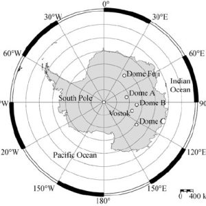
What are the “Domes” ?
 They are very flat snow summits across the Antarctic High plateau. From what I know, they’ve been named more or less according to their altitude while being discovered by the first pilots to fly airplanes across the continent in the 50s.
There are several “Domes” in Antarctica as shown on the Map:
Dome A, Dome B (aka Ridge B), 200 km upstream of the Vostok ice core), Dome C, Talos Dome, Titan Dome, an unnamed ice Dome located near to South Pole and Dome Fuji
Dome A (aka Dome Argus)
 Dome Argus at 80°22′ South, 77°22′ East, has a surface elevation of 4,093 m. It is the highest place in East Antarctica and also one of the least-known places on the globe. An automatic weather station provides data from this remote site.
Dome Argus lies near one end of a ridge about 60 km long and 10 km wide. The ice there is more than 3,000 m thick, overlaying the subglacial Gamburtsev Mountains.
At Dome A, an Automatic weather station (AWS) was set up as part of anAustralian-Chinese collaboration in January 2005. No ground-based scientific investigation had been made at this site before the arrival of the Chinese over-snow traverse team.
Source: Dome Argus – Australian Antarctic Program (antarctica.gov.au)
Dome B (aka Ridge B)
3807 m above sea level at , 79.02°South, 93.69°East, Dome B was discovered at a distance of 170 km from the Russian Vostok Station.
Dome C
Dome C, also known as Dome Circe, Dome Charlie or Dome Concordia, is situated on top of the Antarctic Polar Plateau, the world’s largest frozen desert ever, at an elevation of 3,233 metres (10,607 ft) above sea level, is one of several summits or “Domes” of the Antarctic Ice Sheet.
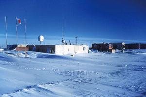
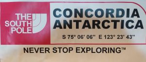 Dome C is the site of the Concordia Research Station (75°06’06” South, 123°23’ 43” East) jointly operated by France and Italy.
In the 1970s, Dome C was the site of ice core drilling by field teams of several nations. It was called Dome Charlie. In 1992, France decided to build a new station on the Antarctic Plateau. The program was later joined by Italy. In 1996, a French-Italian team established a Summer camp at Dome C. The two main objectives of the camp were the provision of logistical support for the European Project for IceCoring in Antarctica (EPICA) and the construction of a permanent research station. The new all-year facility,Concordia Station, became operational in 2005.
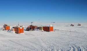
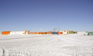 The so called Dome C summer Camp (75°05’59” South, 123°19’ 56” East), about 700 mts from Concordia Station was never dismantled and actually is used as it was in 1996. This Dome C summer camp, pic aside, before the construction of the two towers of Concordia, was the support base of the first Epica project, then it was the support site for the workers who built Concordia Station. Actually, Dome C summer Camp is just a depot with housing and warehouse. All the scientific equipments are inside the towers of Concordia and inside the shelters scattered around the Base. “Dome C Summer Camp” will be add as WAP MNB-NEW to WAP-WADA Directory.
Most of the cargo coming by traverse from Dumont d’Urville Station, covering 1,200 km in 7 to 12 days depending on weather conditions, moved to Dome C and unloaded at the summer camp. Station personnel and light cargo instead arrive by air, using Twin Otter aircraft from DDU or Mario Zucchelli Station at 1200 km.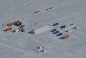
The Project Epica Beyond at Little Dome C is about 32 km from Concordia and the site is called Little Dome C-Epica Beyond, (WAP MNB-NEW).
Dome C North Radar
The radar of the SuperDARN network is located at 1.4 km from the Franco-Italian base Concordia, at Dome C, i.e. very close to the Antarctic geomagnetic pole, at about 3200 m above sea level. This makes it the highest geomagnetic latitude radar and the highest altitude radar. Its field of view conjugates with those of the McMurdo radar and the just installed South Pole radar.’
Super Dual Auroral Radar Network (SuperDARN) radar installed at the Concordia Station in Antarctica and denominated Dome C North (DCN) saw the first light. SuperDARN is an international network of HF radars that observe the effects produced in the ionosphere by the chain of phenomena taking place in the Earth’s space environment. DCN and its companion radar Dome C East (DCE) are positioned nearby the southern geomagnetic pole with their Field of View extending towards the auroral latitudes. Here we present the analysis of the first year of observations as a function of the interplanetary conditions.
and: SuperDARN radar now operating at Dome C in Antarctica!
Talos Dome
 Talos Dome is an ice dome on the edge of the East Antarctic plateau; because accumulation is higher here than in other domes of East Antarctica, the ice preserves a good geochemical and palaeoclimatic record. A new map of the Talos Dome area locates the dome summit elevation (2318.5m) using the global positioning system (GPS) (72˚47’ 14’’South, 159˚04’ 2’’ East).
Source : Geophysical survey at Talos Dome, East Antarctica: the search for a new deep-drilling site | Annals of Glaciology | Cambridge Core
Titan Dome
Based on sparse data, Titan Dome has been identified as having a higher probability of containing ice that would capture the middle Pleistocene transition (1.25 to 0.7 Ma). New aerogeophysical observations (radar and laser altimetry) collected over Titan Dome, located about 200 km from the South Pole within the East Antarctic Ice Sheet, were used to characterize the region (e.g., geometry, internal structure, bed reflectivity, and flow history) and assess its suitability as a paleoclimate ice core site.
Dome Fuji (aka Dome F)
 Dome Fuji also called Dome F or Valkyrie Dome is an ice dome rising to about 3,810 m (12,500 ft) above sea level in the eastern part of Queen Maud Land (77°30’South, 37°30’ East).
Dome F it’s the second-highest summit or ice dome of the East Antarctic Ice Sheet . Dome F is the site of Dome Fuji Station, a research station operated by Japan
Located in the eastern part of Queen Maud Land, Dome Fuji is a zone of ice that characterizes it as a special place, with more than 720,000 years of history recorded in its ice. Japan was encouraged to install a scientific base, Dome Fuji Base, despite the complexity of its supply and maintenance.
DOME FUJI: 720,000 YEARS OF HISTORY IN ICE – Inuit WindSled (greenland.net)