Mobile networks have been assisting scientists with Antarctic research.
Scientists have been studying giant holes of open water in Antarctic ice, called polynyas, in the Weddell Sea. A team from the University of Washington has been assisted with robots and seals with antennas attached to their heads.
The robots and seals have used mobile networks to send data back to the scientists. TNX Bhagwati VU3BPZ
The scientists’ latest findings were published in the journal Nature.
In 1955 Chile inaugurated its station Pedro Aguirre Cerda at Pendulum Cove (62°56 South, 60°36 West), to increase the Chilean presence in the sector claimed by that nation.
At the Chilean station Pedro Aguirre Cerda andthe nearby Gutierrez VargasRefuge scienmtists did perform studies of meteorology and volcanology.
Today only ruins remain.
When the US Coast Guard icebreaker Eastwind visited Deception Island in 1963/64, the British and Chilean scientific stations were active. The Chileans had an airstrip, with a DeHavilland Beaver supplying their base from Punta Arenas.In 1969, a violent volcanic eruption demolished the Chilean stations Pedro Aguirre Cerda and Gutierrez Vargas Refuge. Remains at Whalers Bay include rusting boilers and tanks, an aircraft hangar and the British scientific station house (Biscoe House), with the middle torn out by the 1969 mudflows. A bright orange derelict airplane fuselage was removed in 2004. Deception Island has become a popular tourist stop in Antarctica because of its several colonies of chinstrap penguins, as well as the novel possibility of making a warm bath by digging into the sands of the beach.
Last activity from this rare Old site in Antarctica (WAP CHL-Ø4) was made by F5PFP operating as CE9XX on March 2011.
In 1819, the Sailing Vessel San Telmo, commanded by Captain Joaquín de Toledo y Parra, was the flagship of a Spanish naval squadron under Brigadier Rosendo Porlier y Asteguieta bound for Callao (Peru) to reinforce colonial forces there fighting the independence movements in Spanish America. Damaged by severe weather in the Drake Passage, south of Cape Horn, it sank in September 1819.
The 644 officers, soldiers, and seamen lost on board the S/V San Telmo may have been the first people to die in Antarctica, as parts of her wreckage were found months later by the early sealers visiting Livingston Island. Indeed, if any of the crew of the San Telmo survived to set foot there, they would have been the first people in history to reach Antarctica.
San Telmo Island off the north coast of Livingston Island is named after the ship.
If someone is going to Cádiz (Spain) this summer, don’t forget to visit the exhibition that recalls the trip of the Sailing Vessel San Telmo, the first ship that could reach Antarctica, and its 644 crew missing members. The exhibition, organized by the Naval Museum of San Fernando is open to the public until next August 31.
The museum is owned by the SpanishMinistry of Defense, and is peripheral to the Naval Museum of Madrid.
On WAP website, we have recently add a new page called “Arctic & Antarctic Global Program”, a French proposal for Hams, launched years ago by F5PFP (f5pfp@sfr.fr), to whom address requests of information, or asking for the “form” to list the stations worked.
Pic aside shows F5PFP when signing VP8DLM in Antarctica.
The combination of the Antarctic & Arctic Challenges scores allows the landing to a global scores called Polar Trophy.
The Captain Caillet-Bois, Naval Refuge (63º 54 ’40” South, 60º 47′ 52″ West), is an Argentina’s refuge in Antarctica, 30 meters above sea level on the small D’Hainaut island, Port Mikkelsen bay, Trinity Island, one of the Palmer archipelago. It was inaugurated by the Argentine Navy on December 10th , 1954. Its original name was Port Mikkelsen Refuge.
In March 2017, it was renewed by a task force of the M/V ARA Bahía San Blas; a group of 6 Navy men remained for 8 days in the shelter making maintenance and replace spare parts until March 17, 2018.
On the evening of the first day of navigation in Antarctica, the M/V ARA “Bahía San Blas” anchored near Trinidad Island, where the Capitán Caillet Bois Naval Refuge is located, thus starting the operations of the final stage of the 2018Antarctic Summer Campaign.
Volker Strecke, DL8JDX (pic taside) informs that next 14th November 2019 in Dresden, Germany there will be an Antarctic Meeting of many Polar Veterans on the occasion of 30th Anniversary of the border opening between former East and West Germany and the later reunification as well as the related impressions from that time at Georg Forster (WAP DDR-Ø1)and Neumayer II (WAP DEU-Ø2) Stations.
Nine years ago, Mehdi Escoffier, F5PFP did set a great Antarctic Expedition which have reached several rare spots such as Bases, Huts and Refuges in Antarctica.
On last 4 December 2018, we did inform the Antarctic chasers that, as regards of VP8DLM, FT5YK , CE9XX (2011 Antarctic Expedition), Mehdi, F5PFP was going to print a new batch of QSL cards as the old ones have been almost exhausted.
Now the cards are ready (see the pics aside) and Mehdi , F5PFP has informed, through a post on Antarctica List (antarctica_list@yahoogroups.com ), that these new QSL cards are available.
Those interested can write to MehdiF5PFP ( f5pfp@sfr.fr ) to arrange how to get them.
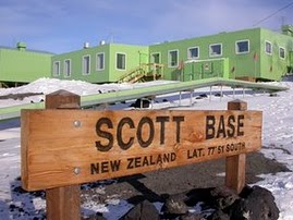
Scott Base (WAP NZL-Ø1) is getting old. Antarctica NZ wants a complete replacement; to dom that plan, Antarctica New Zealand must raise $50 million in charitable donations as part of its $250m Scott Base rebuild.
The state agency plans a 10,000 square-metre new base with three interconnected buildings on the same site as the existing base. It will include 100 beds, science labs, meeting spaces, a cafeteria and pub, and a hangar for two helicopters.
Scott Base redevelopment Senior Manager Simon Sheltonsaid the current base was reaching the end of its functional life.
Mehdi Escoffier F5PFP has just published the 2019 Antarctic and ArcticChallenge ranking and the Polar Trophy score, a kind of an adventure shared by Old Timers all over the world.
Collecting rare spots, make contacts to such remote locations through the Ham radio is not just an hobby, it’s a real passion!
Join us and enjoy this real fascinating world!
For reasons of space, we publish only the first 10 Hams classified but we refer you to antarctica_list@yahoogroups.com to see the full list
[table “9” not found /]
[table “10” not found /]
[table “11” not found /]
It’s a great emotion to see our great friend Reg Beck VE7IG (SK) on all the 3 lists; Reg was great man, great DXer, professional Radio operator and a good friend, we will keep forever a great recall of him!
Never too late … Let’s once again join the guys in Antarctica in the celebration of Mid Winter!
Our friend and Antarctic veteran Volker Strecke , DL8JDX reports his experience when he did overwintering in Antarctica and wrote to his colleagues who did share that experience at the time: -It is still fascinating that now, after 28 years from our joint overwintering we are still well connected-
Also, Volker recalls his friend Mikhail Fokin RW1AI who was at Novo Base (WAP RUS-Ø8) at the time and who is currently working at the Arctic Research Station Cape Baranov on Severnaya Zemlya.
Kindest regards to the people spending this particular time of the year in Antarctica! Stay healthy. Happy Midwinter Day
Yours, Gabi and Volker Strecke, DL8JDX
Antarctic Overwintering Expeditions:
1.AE Georg Forster 1988-1989 Y88POL (WAP DDR-Ø1)
4.AE Georg Forster 1990-1992 Y88POL (WAP DDR-Ø1)
13.AE Neumayer II 1992-1994 DPØGVN (WAP DEU-Ø2)
TNX Volker Strecke, DL8JDX
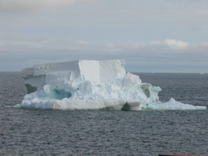
Mobile networks have been assisting scientists with Antarctic research. Scientists have been studying giant holes of open water in Antarctic ice, called polynyas (see below), in the Weddell Sea. A team from the University of Washington has been assisted with robots and seals with antennas attached to their heads. The robots and seals have used mobile networks to send data back to the scientists.
The scientists’ latest findings were published in the journal Nature https://www.commsmea.com/technology/19729-mobile-networks-helping-with-antarctic-research
A polynya is an area of open water surrounded by sea ice. It is now used as geographical term for an area of unfrozen sea within the ice pack.
https://www.youtube.com/watch?v=vqlpZd5rydg
It is a loanword from Russian which refers to a natural ice hole, and was adopted in the 19th century by polar explorers to describe navigable portions of the sea.
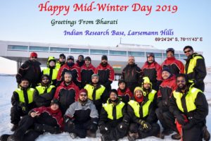
We have chosen a couple of sites in Antarctica (Concordia StationWAP MNB-Ø3, and Bharati BaseWAP IND-Ø4) were the personnel have shared the happiness of June 21, better known as Mid Winter Day.
Midwinter Day marks the halfway point through Antarctica’s cold and dark season.
The first Midwinter’s Day was celebrated in 1898 by the crew of the Belgica, a Belgian vessel that became stuck in pack ice and was forced to overwinter until it finally broke free in February 1899. Unprepared to spend a winter in Antarctica, many of the crew suffered from scurvy, which was only alleviated after the men began to eat seal and penguin meat that provided essential vitamins.
Mid Winter Day is marked with a feast and other activities.
Below, the Artigas Base (WAP URY-Ø1) on the longest night on the planet celebrated during the “Day of the Antarctic Confraternity”.
This day marks the beginning of winter and festivities are traditionally held among the Antarctic bases as “Mid Winter day” in order to motivate themselves to overcome the challenge of the rigor in this unique geographical site!
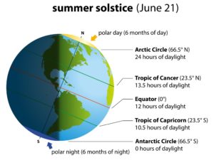
June 21, in the northern hemisphere the sun will rise at 5.36 and set at 8.51, remaining in the sky for 15 hours and 15 minutes, while between the Arctic Circle and the North Pole it will not fade at all. The Northern hemisphere will live the longest day of the year.
In the Southern hemisphere, will happen just the opposite, in other words they will experience what happens to us on December 21st: their night will be the longest of the year, while between the Antarctic Polar Circle and the South Pole the sun will never arise.
Happy summer to all of those living on the Boreal hemisphere, and happy winter to those living on the Austral one!
Professional news media invited to apply to visit jointly funded US and UK research on Antarctic Thwaites Glacier.The National Science Foundation (NSF) and the International Thwaites Glacier Collaboration (ITGC) are accepting written proposals from media professionals to visit a “deep-field” camp on the remote Thwaites Glacier in West Antarctica in December.
NSF, the UK’s Natural Environment Research Council (NERC), and the ITGC Science Coordination Office (SCO) will jointly select a very limited number of media personnel-no more than three people in total–to deploy initially to the West Antarctic Ice Sheet (WAIS) Divide field camp, which will serve as the hub of the research being carried out at Thwaites Glacier. Media will be free to interview Thwaites research teams as they deploy through that camp. A visit to an additional Thwaites Glacier field camp will be highly dependent on weather and logistical variables, and, while possible, cannot be guaranteed.
There is also a separate opportunity for one person to report from the R/V Nathaniel B. Palmer when a team of ITGC scientists sails for Thwaites Glacier in February of 2020 for approximately 50 days.
US Shackleton Field Camp 85°05’24” South,175° 19’ 48” West is a “Summer camp” opened in 2015.
Shackleton Field Camp, 459 Nautical Miles from McMurdo Station (WAP USA-22) is one of the seven field camps managed by USAP in Antarctica where field sites have resident staff to provide logistical and operational assistance to McMurdo and vessel-based researchers. Personnel (logistics, scientists and researchers) normally leave McMurdo aboard a Hercues C-130 to reach the remote Shackleton Glacier field camp (WAP USA-NEW).
The Shackleton glacier is a vast glacier that descends from the polar plateau through the chain of mountains of Queen Maud (Transantartic mountains) and then flows into the Ross platform. Recently, from this well-equipped “base camp”, the researchers went to an area along the McIntyre headland by a Twin Otter and over there, they discovered the oldest Antarctic forest so far known, plus a number of other fossil plants that grew in the undergrowth and collected ashes from as many as six volcanic eruptions. The ashes contain a variety of zircons which in turn contain uranium atoms: this allows the scientists to date the fossils (radiometric dating) and to establish precisely the age of the Glossopteris forests and to understand if these plants have survived the great extinction of mass of the Permian.
So far, nobody (radio amateurs) has been active on the Ham bands from Shackleton Field Camp which of course is still a WAP USA-NEW one. Now we will add it on the WAP WADA Directory hoping someone to be active one day or another from there!
Located at 74°20’South, 165°08’ East, Edmonson Point is a rounded, largely ice-free point lying below Mount Melbourne along the west side of Wood bay, Victoria land.
It was mapped by the US Geological Survey from surveys and from US Navy air photographs, in the years 1955–63, and was named by the Advisoy Committee on Antarctic names for Larry Edmonson, a satellite geodesy scientist at McMurdo, winter party 1966.
The point has been designated an Antarctic Specially Protected Area (ASPA 165) because of its terrestrial and freshwater ecosystem. The volcanic lithology and substrates are nutrient-enriched by colonies of Adelie penguins and south polar skuas. The site contains a diverse range of freshwater habitats ,terrestrial vegetation and invertebrates are abundant. Weddell seals breed on the adjacent sea ice.
In December 1985, during the first Italian Antarctic expedition, the Italian party placed the first Italian remote camp (few tents) over the hills overlooking the Terra Nova Bay, looking for the best place to build a new station (named after “Mario Zucchelli” WAP ITA-Ø1). The first automatic weather station (AWS) called Eneide was installed at the top of an hill by Andrea Pellegrini; the place was called Campo Meteo.
An old collection of Magazines (1971-1992) from Argentina, tells us the history and life of the White Continent. (pics aside show the covers of a couple of magazines)
A good friend, Ham radio operator: Pedro LU1JHF, wrote:
– Knowing your passion for Antarctica, I’m pleased to share with you this collection of Magazines, which, I am sure will be of your appreciation!- ’73, Pedro LU1JHF
Everyone can download one by one the Magazines; they are available on the website of the Argentine Chancellery.
Just for everyone pleasure, here below are the links:
Argentina reaffirms sovereignty over the Argentine Antarctic Sector extending between the 25th and 74th meridians of west longitude, south of the 60th parallel of south latitude.
Ever since the opening of the first scientific station (Orcadas BaseWAP ARG-15) in Laurie Island, South Orkney Archipelago, on 22 February 1904, Argentina has been constantly and uninterruptedly present in Antarctica, which constitutes the longest continuous presence in such continent. Argentina has six Permanent Bases:
(Carlini WAP ARG-2Ø, Orcadas WAP ARG-15, Esperanza WAP ARG-Ø4, Marambio WAP ARG-21, San Martin WAP ARG-Ø8 and Belgrano II WAP ARG-Ø6) and seven Temporary Bases (Brown WAP ARG-Ø2, Primavera WAP ARG-Ø9, Decepción WAP ARG-12, Melchior WAP ARG-13, Matienzo WAP ARG-Ø1, Cámara WAP ARG-16 and Petrel WAP ARG-17).
Argentina is one of the twelve original signatories of the Antarctic Treaty signed in Washington on 1 December 1959. The Treaty sets forth that Antarctica is to be used exclusively for peaceful purposes and forbids any military activity, as well as the testing of any type of weapons. Furthermore, it properly protects the reaffirmation of Argentine sovereignty over Antarctica in the face of claims overlapping Argentina’s own. Hence, the geopolitical significance for Argentina of maintaining a strong and effective Antarctic Treaty System, which also ensures the existence of a large peace zone along our southern border.
Ross Island turned green in the weekend! This epic shot of an Aurora Australis captured by the winter Leader Jonny Harrison.
Scott Base, is located at Pram Point, Hut Point Peninsula, Ross Island in McMurdo Sound at
77 o 51′ South, 166 o 46′ East; it’s the New Zealand’s only Antarctic Research Station, perches on a low volcanic headland called Pram Point at the Southern End of Ross Island, 3500kms south of Dunedin and 1350 kms from the South Pole.
Actually ZL5A is active from Scott Base WAP NZL-Ø1 just on FT8 mode, no CW no SSB!
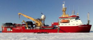
Now the news is official: Icebreaker “Laura Bassi”, former “Ernest Shackleton” of the British Antarctic Survey, is the new OGS ship that will work for PNRA to replace the glorious Italica!
A great result for the whole Italian scientific community, and in particular for the one that studies the poles. The National Institute of Oceanography and Experimental Geophysics – OGS, thanks to a funding received from the Ministry of Education, University and Research (MIUR), has purchased the icebreaker “Ernest Shackleton” of the Norwegian Rieber Shipping already used by the British Antarctic Survey.
Laura Bassi, formerly Polar Queen and RRS Ernest Shackleton, is an icebreaking research vessel, primarily a logistics ship used for the resupply of scientific stations in the Antarctic.
The Icebreaker ship, is named in honor of the Italian scientist Laura Maria Caterina Bassi Veratti who, in 1700 became the first woman, Italian physicist and academic.She was the second woman graduate of Italy after the Venetian Elena Lucrezia Cornaro, the first to pursue an academic and scientific career and the first in the world to obtain a university chair. The N/R Laura Bassi now becomes the only Italian oceanographic research vessel capable of operating in polar seas, both in Antarctica and in the Arctic.
Launched in 1995 as MV Polar Queen for GC Rieber Shipping, she was operated in the Antarctic by other national programs. The British Antarctic Survey acquired her on a long-term bareboat charter in August 1999 and renamed her RRS Ernest Shackleton after the Anglo-Irish polar explorer Sir Ernest Shackleton. She replaced RSS Bransfield. Icebreaker ‘Ernest Shackleton’ will return to Antarctic waters one day as ‘Laura Bassi’.
BAS (British Antarctic Survey) did say goodbye to their former workhorse which will now be operated by the Italian National Oceanographic InstituteOGS. BAS is preparing for arrival of RRS Sir David Attenborough
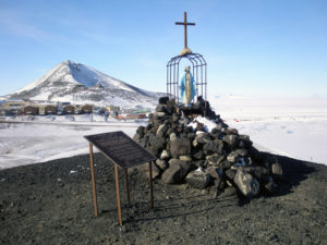
The Our Lady of the Snows shrine is one of the many memorials atop hills along McMurdo Sound to men who lost their lives in Antarctica; this one is farther up the trail from Hut Point. The Shrine is dedicated to Richard T. Williams, US Navy – Seabees, who lost his life at McMurdo Sound on January 6, 1956 during initial construction of McMurdo Station.
Seabee Construction Driver third class, USN, Richard T. Williams died when the D-8 bulldozer he was driving, broke through the ice and sank; his body was never recovered.
He was hauling cargo along a track from the ice edge east toward Cape Evans, when his tractor crashed through the ice into 100 fathoms of water about two miles west of Cape Royds. Plans at the time called for a land airstrip to be built between Cape Evans and Cape Royds to support future exploration and the construction of South Pole Station. Heavy ice prevented the convoy from getting close to Ross Island, prompting the need for a long and hazardous traverse. (Immediately after the accident, this project was abandoned, and aircraft facilities were developed on the ice at what would become the Williams Air Operating Facility).
The following year the Our Lady of the Snows Shrine was erected on Hut Point in memory of Williams. At the original dedication on 6 January 1957; chaplain Father Condit is playing the organ, which had been carried up the hill to the site. During the ceremony, David Grisez, a friend of Williams, played “Taps”. The monument has been repaired and restored more than once…most recently in 1995-96 the statue was refurbished and repainted by Carmelite nuns in Christchurch. It was returned during that season, along with a new plaque furnished by the CEC/Seabee Historical
For many years the statue had faced McMurdo Station, but after the rededication she was turned around to face north out over McMurdo Sound toward where Williams was lost.
Stamps issued by the Argentine Post Office whose vignettes have designs related with the thematic of the Argentine Antarctic and the Malvinas Islands are always a source of great interest, whether it is a commemoration of special events, expeditions, scientific activities, Antarctic bases, Argentine ships that sail in the Antarctic waters.
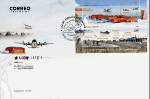
Now, Correo Argentino pays tribute to Antarctica with two postal pieces. We have already seen the 1st one, celebrating the 50th Anniversary of the foundation of Base Marambio (WAP ARG-21).
The second block sheet, is an emission dedicated to the ARA Icebreaker “Almirante Irízar”, a ship that gives logistic support in the summer campaigns supplying the Antarctic Bases, in addition to performing scientific tasks in glaciology, meteorology, the survey of the submarine platform of the Icy Continent.
The print of this series, run in 20,000 copies of each theme and is now available for sale in the E-store or in any philatelic branch of Argentina.
Last Antarctic Activity Week (Febr.2019) has seen a great participation of Hams from several countries WW. Since 16 years, François F8DVD, one of the most active Antarctic enthusiasts, takes part in the event with a special callsign as usual.
Last past AAW 16th edition, he got TM16AAW and now he shows the QSL that will confirm his QSOs.
QSL have been printed by the printing shop at IT9EJW company
The picture shows the Base O’Higgins (WAP CHL-Ø2) which is a Chilean station established in 1948. The O’Higgins Base is situated at Cape Legoupil on Trinity peninsula (63°19’ South, 57° 53’ West). The German Antarctic Receiving Station (GARS) was established at O’Higgins in 1991 by the German Aerospace Center. It is a satellite ground station sited to enable reception of data from satellite-based sensors within the Southern Polar region.
Europe’s dedicated polar-monitoring satellite has produced its sharpest view yet of the shape of Antarctica.
The Cryosat mission has been measuring height changes on the White Continent since 2010 using a radar altimeter instrument. ESA’s CryoSat mission is dedicated to precise monitoring of marine ice in the polar oceans and variations of ice sheets overlying Greenland and Antarctica.
And now its entire data archive has been reprocessed in a way that gives a tenfold improvement in resolution. Whereas Cryosat used to see features at the scale of 1km to 2km, it now sees them at 500m or less.
The new “swath” processing mode, as it’s called, will bring significant advantages in the study of those regions of Antarctica that traditionally have been especially hard for radars to sense. These include the craggy terrains where glaciers will be numerous but relatively small. “So, the benefit in the Antarctic Peninsula for example promises to be massive,” says Dr Noel Gourmelen from Edinburgh University and the UK Centre for Polar Observation and Modelling (CPOM). “The peninsula is the region furthest away from the pole; it’s much warmer there and it’s where we’ve seen the acceleration of glaciers and the collapse of ice shelves.
“We can basically now measure all of the peninsula around the coast which is where the biggest changes have been taking place,” he told BBC News.
A new postal emission for the fiftieth anniversary of Marambio Base foundation1969 – October 29 -2019 is now available to collectors!
Inside the Antarctic Museum of the Marambio Foundation, there is the so-called Antarctic Philatelic Corner, which exhibits philatelic postal pieces that certify various Antarctic events. The corner, bears the name of “Comodoro Salvador Alaimo”, who was a well-known collector of stamps, envelopes and postal marks related to the theme of Antarctica and Malvinas Islands.
“Filatelia del Correo Argentino” has just issued a postal series in tribute to the 50th anniversary of the founding of Marambio Base (WAP ARG-21) in Antarctica Argentina (1969 – October 29 – 2019). Marambio Foundation and Filatelia del Correo Argentino, did provide graphic, historical material and reporting details about this event such as the design of high artistic quality that makes this emission a real great job. Here aside, the postmark of the 1st day emission
The postal series are available in all the Philatelic stores Argentina and on the Internet since April 29, 2019, while the official launching is expected for the month of June, in commemoration of the Day of the Antarctic Confraternidad, 21 of June.
Former Prime MinisterBob Hawke maintained that Antarctica was too important to the whole global ecosystem and that mining would always be catastrophically dangerous in that environment …
Its was a sad day in Australia with the loss of one of the true champions in the preservation of Antarctica. Bob Hawke lead the international push in 1989 which ultimately lead to the rejection of mining in Antarctica.
He instead put his weight behind promoting the frozen and fragile continent as a natural reserve devoted to peace and science.
Mr Hawke was Australia’s 23rd prime minister, dead at 89 on last May 16th 2019
Doctor Guillermo Mann Base (formerly Camp Shirreff) is the second of the three research Bases that INACH (Instituto Antartico Chileno) has in Antarctica. It is located at 62º27’00″South, 60º47’00″West on the east side of Cape Shirreff on Joannes Paulus II peninsula on Livingston Island in the South Shetlands off the Antarctic peninsula.
It is near the US Shirreff Base (WAP USA-NEW) administrated by the United States.
The Base (named after the Chilean zoologist, naturalist and ecologist Guillermo Mann, who participated in 1947 on the first Chilean Antarctic Expedition) , should not to be confused with the “old” Doctor Guillermo Mann or Spring-INACH Base (WAP CHL-NEW) from 1973 that is located in the Spring Point, Hughes Bay (today it’s not operational). http://www.inach.cl/inach/?page_id=12694
Doctor Guillermo Mann Base (WAP CHL-Ø8) has allowed to generate knowledge in terrestrial and marine biology, and disciplines such as geology and glaciology.
Since the site is in a protected area, its access requires a special permit.
The base was inaugurated in 1991, it is equipped with communications HF radios, VHF radios and satellite telephony. Only CE9MFK has been active from Doctor Guillermo Mann Base in 1995 and 1999
Over the weekend, brilliant auroras lit up the skies above Macquarie Island, (WAP AUS-Ø8)
“It was so ridiculously and beautifully bright that all the puddles around station and the ocean really did reflect green” said photographer and station medic Dr Kate Kloza.
“They were some of the brightest I have seen in my polar career, with reds visible to the naked eye” she add.
The Macquarie Island Station in the southern ocean, is a permanent Australian subantarctic Research Base commonly called Macca. The station lies at the base of Wireless Hill, between two bays on the isthmus at the northern end of the island and it’s managed by the Australian Antarctic Division (AAD).
Let us share this amazing view among the WAP readers.
TNX and credit to Dr Kate Kloza, Macca doctor and Australian Antarctic Division
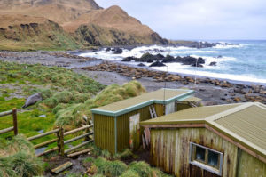
Shirreff Base (official name Cape Shirreff Field Station),is located at 62°28’12” South, 60°46’16” West, on the East side of Cape Shirreff on Joannes Paulus II Peninsula on Livingston Island of the South Shetlands. It’s a seasonal field station operated by the United States, opened in 1996 .
Every austral summer, the US AMLR Program conducts predator studies at Cape Shirreff field Station.
Each week, the field research team sends updates on their work.
Shirreff Field StationWAP USA-NEW and the nearby Chilean Base called Refuge Dr. Guillermo Mann, WAP CHL-NEWare few meters each other and so far no Ham radio operators have been active from there. It’s a real shame, particularly if considering that both locations are visited yearly and an operation from there could qualify both references!
Base Antarctica Belgrano I was located on Piedrabuena Bay on the Filchner Ice Shelf at 77°46’ South, 38°11’ West. At the time of its inauguration in 1954 it became Argentina’s southernmost permanent base. It was shut down in 1980 over safety concerns due to it being built on increasingly unstable ice, which endangered both personnel and equipment.
A new, larger replacement base was established further south, and named Belgrano II (WAP ARG-Ø6) followed by Belgrano III (WAP ARG-Ø7) which became the southernmost of the three.
Brief history of Base General Belgrano I: On 18 November 1954 the Antarctic Naval Task Force commanded by Capt. Alicio E. Ogara (see picture below ) sailed from Buenos Aires with the objective of setting up a base on the Filchner Ice Shelf that would serve as a launch point for expeditions to the South Pole.
On 2 January 1955 the expedition sailed up to the southernmost point of the Weddell Sea at 78° 01′ South. At the time it was the highest austral latitude ever reached by boat, and a new world record was set.
The task force then sailed north along the ice wall, seeking for an anchoring place.
On 3 January 1955Brig.Gen. Hernan Pujato, director of the Argentine Antarctic Institute, flew over the ice shelf area aboard a helicopter to choose a suitable place to mount the base, selecting a small cove where the high wall of ice sloped down to the sea. The unloading of the materials, equipment, tools, instruments and consumables was conducted from ARA General San Martín. The team built a main house, four quonset huts, food stores and hangar. They left on the new base enough fuel for three years.
Belgrano I (WAP ARG-Ø5) was shut down after 25 years of continuous service due to the fast deterioration of the ice barrier it was sitting on; new often hidden cracks and crevices endangered the on-duty personnel and material. The Base was closed on January 1980 and all of its staff and equipment were evacuated by helicopters operating from the Icebreaker ARA Almirante Irizar.
According to WAP-WACA Directory the following stations have been activre at Base Berlgrano I from 1959 through 1963: LU1ZT, LU1ZX, LU1ZW, LU2ZX, LU2ZRM, LU9ZX..Any further information about other stations active from there could be sent to IK1GPG (see QRZ.com
As the white continent warms, shrinking sea ice is changing life for Leopard seals. It was on the northern tip of a small rocky island at the bottom of the world where the solitary top predators suddenly started gathering.
Before 1996 around Livingston Island’s Cape Shirreff, across the windy Bransfield Strait from the Western Antarctic Peninsula, it was almost impossible to find a leopard seal, that sleek hunter with the body half the weight of a small Toyota. As far back as the 1800s, commercial fur sealers who’d slaughtered marine mammals for their pelts kept painstaking records of the animals they saw. Leopard seals, with their powerful jaws, upturned mouths and menacing teeth, weren’t among them.
In recent years, though, a half-dozen hungry leopard seals may bob and weave offshore at once. They often plop onto the cape and nap. As many as 60 or 80 may swing by in a season. Once, researchers saw 30 hauled out at the same time.
Germany is one of the Consultative Parties of the Antarctic Treaty since 1981 and maintains a long-term commitment to scientific research in Antarctica. The Alfred Wegener Institute for Polar and Marine Research (AWI) as the national co-ordinator, enables Germany to fulfill this role by its research, long term monitoring and survey activities. It provides the main mobile and stationary infrastructure for Antarctic research, and thus maintains the permanent German presence in Antarctica. The new institute was named after one of the really prominent German polar researchers, who developed the first in-depth ideas about continental drift.
In austral summer 1979/1980 a scientific expedition under the leadership of Heinz Kohnen on the Norwegian M/S “Polarsirkel” took place in the Weddell Sea. One major issue was the site survey for the selection of a suitable location to build the German research station. A location on the Filchner-Ronne Ice Shelf at 77°36’South and 50° 40’West was selected as a first choice.
Construction, technology and living conditions on the two German Antarctic research stations Georg von Neumayer Station (GvN, operational 1981/82 to 1992) and Neumayer Station II (NM-II, operational from 1992 through 2007 then replaced by a new Neumayer Station III (NM-III) in 2009
Planned under the supervision of Hartwig Gernandt, Neumayer III Station (70°40’S and 08°16’W) WAP –DEU-Ø8, was inaugurated on 20th February 2009 as the new German Antarctic research Base. It is operated by the Alfred Wegener Institut (AWI) Helmholtz-Zentrum für Polar-und Meeresforschung and follows the Georg-von-Neumayer Station (1981-1992) WAP DEU-Ø1 and Neumayer II Station (1992-2009) WAP DEU-Ø2 as the German overwintering station on the Ekström Ice Shelf in Antarctica.
Neumayer III StationWAP DEU-Ø3 integrates research, operational and accommodation facilities in one building (see video below).
Gene Spinelli K5GS (pic aside: Left-Gene K5GS, Right-Steve W1SRD) did respond to the question we put him about next planned South Orkney Expedition. We recall him that: –The 3 locations: Cummings Hut, Foca Hut and Gourlay Huts (see the article of 18 march 2019 here on the page of WAP website) have never been put on the air, so the interest could be higher at least among the Antarctic Hunters if you eventually can activate one or more of them!-
Gene said: –We will have a look at them and determine if any can be used. The skipper of Braveheart has been to South Orkney and is familiar with the location used by VP8ORK in 2011… Distance from the beach is important, we have to carry everything we bring ashore- Gene Spinelli K5GS will be at Friedrichshafen (next June 21-23), I’m sure some of the Antarctic Chaser friends will meet him and come back with some fresh information! Let’s keep our finger crossed !
General Artigas Station (WAP URY-Ø1) is the larger of the two Uruguayan scientific Research Stations in Antarctica, the other one, is Elichiribehety Base (WAP URY-NEW)
Archbishop Sturla would like a chapel at Artigas Base, but the military authorities do not seem inclined to grant the request!
The cardinal of Montevideo, Rev. Daniel Sturla expressed the desire that Uruguay, like other nations of Latin America and other Countries of the world, have its own Catholic chapel in Antarctica.
The existence of a letter was revealed by the weekly Busqueda magazine and was written in September 2015 to General Claudio Romano, who then presided over the Governing Council of the Antarctic Institute of Uruguay. The cardinal’s letter, awarded in September of that year with this title by Pope Francis, begins by referring to request that came from people linked to the Artigas Base of Uruguayan Antarctica.
Artigas Base is a small scientific research station founded in 1985 in the white continent. It is precisely here that, the Archbishop of Montevideo would like to have a “chapel dedicated to prayer and personal reflection” erected.
The base is active all year with an allocation of 8 people in winter and 70 in summer. -We think that for our compatriots who spend a season there- writes the archbishop of Montevideo, -the presence of a chapel and a place suitable for the image of our Patroness can only be beneficial-.
In Artigas Base operates a meteorological station that forms part of the worldwide network. For years in the Base, there has been an image of the Virgen de los Treinta y Tres (Our Lady of the Thirty-Three), Patroness of Uruguay. -This call of the Mother of Jesus is linked to our homeland history- observes Monsignor Sturla .
National independence was proclaimed at the foot of the original image. Many patriots worship her and General Don Manuel Oribe, as a vote after a shipwreck, placed the golden crown with which he was honored on her head. Other nations present in Antarctica also have their chapels”.
Here below, an interesting video that tells the history which we would like to share with the Antarctic chasers:
Our Lady of the Thirty Three may not be very well known, because She has little history. In 1825, the 36 centimeter statue was brought to what is now Florida City, Uruguay by 33 orientals. In 1857, one of them, Manuel Oribe, gave her a small golden crown. In 1962, Bishop Humberto Tonna crowned it solemnly, and soon afterwards, Bl. Pope John XXIII declared it Patroness of Uruguay. In 1988, during Bl. Pope John Paul II‘s visit to Uruguay, he consecrated it.
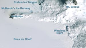
Windless Bight (77°42’00”South, 167°39’48” West) is the prominent bight indenting the South side of Ross Island Eastward of Hut Point Peninsula.
Windless Bight‘s location on the Ross Ice Shelf is unique for its very low wind levels, which makes infrasound detection possible. Infrasound can detect volcanic eruptions, winds over distant mountain ranges, large storms at sea, auroral and meteor events, earthquakes, avalanches, and human-caused events such as very large explosions.
A field team, equipped with standard remote field equipment (including snowmobiles, PistenBully, and Mattrack vehicles) stays over there in this self-supporting field camp several weeks a year.
The camp consists of two Polarhavens and six individual mountain tents. The team remains at the field site but will intermittently return one or two team members to McMurdo Station for supplies and overnight stays. The USAP also provides year-round on-site support from a support contractor research associate (RA), who occasionally visits the site during winter months for maintenance and troubleshooting. Read more at:https://www.usap.gov/scienceSupport/sciencePlanningSummaries/2018_2019/results.cfm?formAction=detail&ID=199
Windless Bight Field Camp will be add to the WAP-WADA Directory to appear in the next update. So far no ham radio activities have been performed from this site. If it will happen, a new WAP Reference will be given.
Antarctica, the coldest continent on earth, has served as a scientific research zone since the signing of a 1959 treaty. Recently, Turkey and Belarus signed an agreement that covers scientific cooperation on environmental conservation and study of Antarctic geology; the cooperation on Polar research, happens months after Turkey completed its third National Antarctic Science Expedition.
The agreement on scientific and technical cooperation in Antarctica was signed by Turkey’s Industry and Technology Minister Mustafa Varank and Vladimir Gusakov, the chairman of the Presidium of the National Academy of Sciences of Belarus.
Covering cooperation on topics of joint research about the Antarctic as well as exchanges between the countries’ scientists and experts, it prioritized environmental conservation and the monitoring of human impact and pollution on Antarctica.
Earlier in February, a Turkish team traveled to Antarctica as part of a research expedition and spent 30 days in the frozen continent.
One of the 7 temporaryArgentinean bases in Antarctica, has recently celebrated its 66th Anniversary. Located between Carlini Base (WAP ARG-20) and Base Decepción (WAP ARG-12), Camara Base is open in summer to carry out specific scientific studies such as: meteorological observations, oceanography, coastal geology, bird studies and environmental management.
Camara Base (WAP ARG-16) was named after Frigate Lieutenant Naval Aviator Juan Ramón Cámara.
As of 2014, Cámara was one of 13 Research Bases in Antarctica operated by Argentina. From 1953 to 1988 it served as a permanent base; since then it is open during the summer season only.
Although the average temperature is -2.9 °C, on August 12, 1954 an absolute minimum of -30ºC was recorded.
Since 1959, guest scientists from East Germany had stayed for wintering and worked in the field at several Russian Antarctic Stations, likewise scientists from West Germany joined US expeditions.
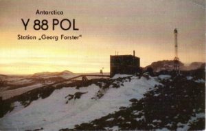
In 1974 the Antarctic Treaty was signed by East Germany, which reached Consultative Status in 1987. The first permanently operated DDRResearch Base, named Georg Forster Station, (WAP DEU-Ø1) was established in 1976 in the Schirmacher Oasis at 70°46’ South, 11°41’ East.
On 22 March, 1988, a 35p stamp to commemorate the 12th anniversary of its founding, was issued by East Germany depicting the Research Station, some distant hills and the Southern Ocean. Below on the stamp, is the inscription Antarktisforschungsstation der DDR “Georg-Forster”.
At that time the concept using pre-fabricated container modules for laboratories, power plant and accommodation was pioneering. Altogether eight container modules were carried on sledges from the unloading site at the ice edge of the Lazarev Ice Shelf, over a distance of 120 km into the Schirmacher Oasis and assembled to a Research Base within only six weeks. Since then, the Station was permanently used and operated as an annex to the Russian station Novolazarevskaya until 1987.
Following the German reunification on 3 october 1990, the East German Antarctic Program was absorbed into that of German Federal Republic which maintains the name of the Base as Georg Forster StationWAP DEU-Ø3, until 1993 and then dismantled in the frame of a German-Russian project, which was completed in 1996.
Long-term studies of magnetospheric-ionospheric processes, geophysical investigations, biological studies and sea-ice observations using satellite imaging were performed. One module close to the antenna mast accommodated the radio transmitting system for ionospheric studies.
Pliocene beech fossils in Antarctica, when CO2 was at similar level to today point to planet’s future.
Trees growing near the South Pole, sea levels 20 metres higher than now, and global temperatures 3C-4C warmer. That is the world scientists are uncovering as they look back in time to when the planet last had as much carbon dioxide in the atmosphere as it does today.
Using sedimentary records and plant fossils, researchers have found that temperatures near the South Pole were about 20C higher than now in the Pliocene epoch, from 5.3m to 2.6m years ago.
Leaves of the extinct southern beech (Nothofagus beardmorensi) have been found at Oliver Bluffs, in the Transantarctic mountains, Antarctica.
We must applaud the Russian Antarctic operators and their QSL managers for the punctuality with which they deliver our QSLs.
This time we have to thank RN1ON Alexei V. Kuz’menko (pic on top) for RI1ANW and RI1ANL QSL cards received very fast!
Alexey is QSL manager for several stations operating from Antarctica and he has been in Antarctica several times as well.
Check his page on QRZ.com to get the list of the Russian stations he is manager for.
Alexey is asking QSL direct o via bureau and says: All QSL`s received direct (with SASE = SAE + 2USD or 1 NEW IRC) will send direct also. QSL received Direct without SASE will send buro.
RI1ANL and RI1ANW (QSLs shown below) are both transmitting from Novolazarevskaya Station, Shirmacher Oasis, Dronning Maud land, Antarctica and that’s WAP RUS-Ø9
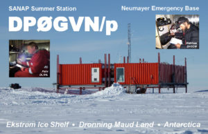
Matthias, DH5CW, and Felix, DL5XL, have been active from the South Africa SANAP Summer Base, WAP ZAF-11 (also known as Neumayer Emergency Base), Grid Locator IB59UJ, from January 8 to 9, 2019 as DPØGVN/p. They left the German Neumayer III Station and in few hours trip, they reached the site from where, they have been active for 2 days.
For those who did work DPØGVN/p from this rare Station in Antarctica, a brand new QSL card will be available shortly through DL5EBE Dominik, the QSL manager.. Front side of the card is shown here, thanks to Felix DL5XL & Dominik DL5EBE
Talking about this Neumayer Emergency Base or SANAP Summer Base is something not too easy as there is not much literature available due to the changes over the years of both the South Africa SANAE Bases and the German Neumayer Stations.
Both Countries had to decommission their Bases more than once, due to the instability; several stations have been built to replace older stations that had to be abandoned due to snow drift.
Just for example, the first E-Base was constructed and commissioned in January 1985 as a refuge in cases of emergency for the SANAE 3 (now decommissioned) over wintering station; She was located at 70° 17’ 80” South, 02° 25’ 56” West on the Fimbulisen ice shelf approximately eleven kilometers inland from the Penguin Bukta. During the summer periods, E-Base was actively used as accommodation for relief voyage and logistical personnel.
Actually, E-Base (SANAP Summer Base) is located at 70° 30’ South, 08° 15’ West on the route between SANAE IV (70°40’79” South, 08°16’15” West) and Neumayer III Station (70°40’25” South, 02°49’44” West) and is a South Africa logistical platform, resulting by a joint venture between the South African National Antarctic Programme (SANAP) and the German Alfred Wegner Institute (AWI).
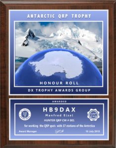
DX TROPHY AWARDS GROUP issues a Trophy called “ANTARCTIC QRP TROPHY” which is given for QSO’s with Antarctica for QRP QSO report marked on QSL.
This is the last one of the three Russian Awards recently issued by DX TROPHY AWARDS GROUP (the other two have been already shown in the previous pages of this website)
“ANTARCTIC QRP TROPHY” is issued 4 Award’s Classes:
Bronze, 10 QSOs Silver, 15 QSOs Gold, 20 QSOs Honor Roll for more 30 QSOs
Any Antarctic Bases or Stations are valid. Plaques will be issued for CW, SSB or MIX. Confirmation: scans of QSL cards or screenshots LOTW/Club Log.(your CALL/QRP marked on each QSL is needed for cfm)
Plaque made on a glossy silver, size 250 x 200 mm.
Plaque cost: $ 53 or 48 EURO. (Payment via PAYPAL)
The application in a free form and questions can be sent to: mydxtrophy@gmail.com
MiKe Luedemann, DL2OE (pic aside), has been in the Argentinean & Chilean sides of Tierra del Fuego (Sub Antarctica) where he has been active for quite a while, in CW and SSB.
Mike did sign LU/DL2OE from 27 March through April 4th operating from the city of Tolhuin about 100 km north of Ushuaia (Isla Grande de Tierra del Fuego)WAP ARG-23.
From April 4 to 7 he was on the Chilean side of Tierra del Fuego and he operates as CE8/DL2OE from Karukinka Park, the southernmost National Park in Chile (locator FD55PU), WAP CHL-13.
DL2OE is actually ongoing his journey across South American, visiting few different Countries as planned. We are grateful to Mike for 2 WAP references from the Sub Antarctic southern tip of South America,
April 16th, marks the anniversary of the blessing and inauguration of the oratory of the Chapel at Base Marambio.
On April 16, 1996, a solemn ceremony was held at Marambio Base (WAP ARG-21), where the Military Bishop of the Argentine Republic at the Solemn Pontifical, proceeded to bless and inaugurate the Oratory of the Base, place under the invocation of the Blessed Virgin of Luján .
In this chapel on October 23, 2014, a wooden chest with a glass lid was discovered, containing a rosary and the skullcap that Pope Francis used, along with a parchment framed with the blessing of the Holy Father to the Antarctic, all this brought from the Vatican, when the President of the Marambio Foundation had an audience with His Holiness in the month of May 2014; act performed at Marambio Base, which is recorded in a document signed by the authorities present.
When the ice closed in, the earliest Antarctic expeditions turned to the birds for discovery, meat, and camaraderie.
In the middle of the Southern Ocean, time is measured in latitude and longitude, wave height and wind speed and the proximity of an iceberg. Ice is the language of ocean and land in the waters around Antarctica, and it is on the floating platforms of ice, those liminal places between land and ocean, that emperor penguins gather every year to mate and, if conditions are right, to lovingly raise their chicks.
The largest and heaviest species in the penguin family, the emperor was given its scientific name, Aptenodytes forsteri, in honor of Johann Reinhold Forster, the naturalist on board James Cook’s second voyage to the Southern Ocean. (Aptenodytes means “featherless diver.”) Forster was likely the first person to see the bird, although he mistakenly identified it as a king penguin, the emperor’s closest relative. More at: https://www.theatlantic.com/science/archive/2019/04/penguins-southern-ocean-explorers-best-friend/586189/
A nice and instructive movie on Macquarie island in which appears Kevin VKØKEV from 13mns 00s to 13mns 45s, will lead the Antarctic Chasers through this fascinating Sub Antarctic island, full of history and Research sites.
Out of those already known, there are other four Huts that merit a stop by.
Hurd Point Hut(54° 46.3′ South, 158° 49.6′ East) is the most remote of all the field huts on Macquarie Island. It is located approximately 32 km south of Macquarie Island station and comfortably sleeps four people. The trek to Hurd Point is generally completed over two days, with an overnight stop at Green Gorge or Waterfall Bay.
The site was originally part of an auroral observatory complex established in 1953 in order to carry out simultaneous observations in conjunction with the station.
Today the hut is mainly used as a base for research in the southern sector of the island and serves as an important base for albatross researchers during summer.
Green Gorge Hut (54° 37.9′ South, 158° 53.9′ East) is located on the east coast approximately 15 km south of Macquarie Island station, roughly halfway down the island. It consists of a comfortable Canadian log cabin built to accommodate five to six people, a food store and storage shed. It is a favorite field hut for many expeditioners.
Green Gorge Hut is very popular as a place to enjoy an overnight break on a journey from one end of the island to the other. The Hut is readily accessible from the overland track or via inflatable rubber boat.
Bauer Bay Hut (54° 33.3′ South, 158° 52.6′ East) is located on the rugged west coast of Macquarie Island approximately seven km southwest from Macquarie Island station. The hut is easily accessible and is the only hut located on the exposed windswept rugged west coast.
The hut accommodates four to five people and is popular with expeditioners travelling down the island or as a weekend retreat for station-based personnel. The hut is well placed to provide a stepping off point for trips to the north or south of along coastal walking routes.
The Hut is accessed via the Island Lake track, or via the Bauer Bay track that links up with the overland track. It can also be accessed by the featherbed track along the north-west coast. The Featherbed and coast to the north of the hut is designated category one Special Management Area and is generally open for to access from June to July. The featherbed south of the hut is designated category two Special Management Area and is generally open to access from April to August.
Caroline Cove Hut –54° 45.8′ South, 158° 47.5′ East- (Last pic to the Left) is located at the foot of Mt.Haswell, in the spectacular Caroline Cove area ; this is within a Specially Managed Area (SMA) with access year-round limited to people approved through a TASPWS access permit.
These 4 Huts have never been activated by Hams, therefore they remain WAP AUS-NEW
Russia and China have got a joint symposium on March 25th, the first event in a series of meetings the scientists have scheduled.
Russian and Chinese scientists will organize joint studies of the Arctic and Antarctic, they will explore mineral and biology resources in the global ocean.
Lake Mercer, 84° 39’ 39” South, 149° 40’ 37” West, is a subglacial lake in Antarctica, that has remained untouched for millennia. Scientists accidentally discovered the lake in 2007.
Over December 2018 – January 2019, SALSA (Subglacial Antarctic Lakes Scientific Access) set up a field camp of 50 scientists, drillers, and support staff and drilled 4,000 feet into the ice to sample from Mercer Subglacial Lake. Located roughly 500 miles from the South Pole, team members reached the study site using specialized tractors and ski equipped aircraft. The project is uncovering new knowledge about this newly explored biome through an integrative study of subglacial geobiology, water column and sedimentary organic carbon, and geobiological processes in one of the largest subglacial lakes in West Antarctica.
The studies will probably continue for some years. So far nobody has thought to set a Ham radio activity even in the free time; if someone will be active from there, a new WAP reference will be given.
“DX TROPHY AWARDS GROUP” issues a new recognition to Hams ho can prove two-way radio communications with the Countries that have Research Stations in Antarctica; this is called “АNTARCTIC NATIONS TROPHY”. To get it, the applicants need to work Bases of various Countries in Antarctica according to the list shown below.
The basic plaque is Bronze available for working (Antarctic region) 5 different Countries,
Silver for 10 different Countries, Gold for 15 different Countries ,HONOUR ROLL for 20 different Countries, EXCELLENCE, for working 30 Countries + 1 Multinational. The Awards are issued for different classes or different modes: CW, SSB ,DIGI & MIX. The applicants have to send scan QSL cards or screenshots LOTW/Club Log.
Upper part of plaque is made by glass, the lower part is metal plate with a size of 250х200. Plaque cost is 51$ or 47 Euro
List of Countries in Antarctica valid for Аntarctic Nations Trophy
TurkishTeam visits 9 foreign research bases, including Spain, Britain and Russia
Turkish scientists stationed in an Antarctic polar research base paid a visit on Monday to other countries’ research installations.
As part of the Third National Antarctic Science Expedition, the Turkish Team visited bases where scientists from Bulgaria, Ukraine, Britain, Chile, Spain, Poland, China, South Korea and Russia were conducting research. Dragomir Mateev, head of the Bulgarian base, told Anadolu Agency that Turkey and Bulgaria achieved great cooperation in polar research which they hoped would continue. Istanbul Technical University (ITU) professor Safak Altunkaynaksaid she would work two months in the Bulgarian Base to investigate different types of volcanic rock.
Earlier in February, a Turkish Team traveled to Antarctica as part of the Third National Antarctic Science Expedition to spend 30 days, which is supported by the Turkish Presidency, the Industry and Technology Ministry, and ITU’s Polar Research Center, along with other Turkish universities.
In April 2016, the first-ever Turkish team of researchers — including doctors, botanists, geologists, and oceanographers from seven universities — traveled to Antarctica to study the impact of climate change. Antarctica, the coldest continent on earth, has served as a scientific research zone since the signing of a 1959 treaty.
 Mobile networks have been assisting scientists with Antarctic research.
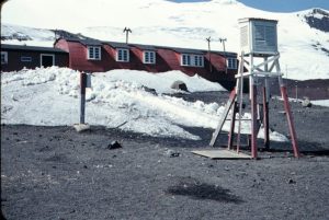 In 1955 Chile inaugurated its station Pedro Aguirre Cerda at Pendulum Cove (62°56 South, 60°36 West), to increase the Chilean presence in the sector claimed by that nation.
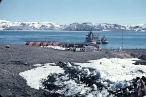 In 1969, a violent volcanic eruption demolished the Chilean stations Pedro Aguirre Cerda and Gutierrez Vargas Refuge. Remains at Whalers Bay include rusting boilers and tanks, an aircraft hangar and the British scientific station house (Biscoe House), with the middle torn out by the 1969 mudflows. A bright orange derelict airplane fuselage was removed in 2004. Deception Island has become a popular tourist stop in Antarctica because of its several colonies of chinstrap penguins, as well as the novel possibility of making a warm bath by digging into the sands of the beach.
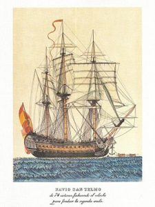 In 1819, the Sailing Vessel San Telmo, commanded by Captain Joaquín de Toledo y Parra, was the flagship of a Spanish naval squadron under Brigadier Rosendo Porlier y Asteguieta bound for Callao (Peru) to reinforce colonial forces there fighting the independence movements in Spanish America. Damaged by severe weather in the Drake Passage, south of Cape Horn, it sank in September 1819.
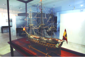 an Telmo Island off the north coast of Livingston Island is named after the ship.
 On WAP website, we have recently add a new page called “Arctic & Antarctic Global Program”, a French proposal for Hams, launched years ago by F
 , Port Mikkelsen bay, Trinity Island, one of the Palmer archipelago. It was inaugurated by the Argentine Navy on December 10th , 1954. Its original name was Port Mikkelsen Refuge.
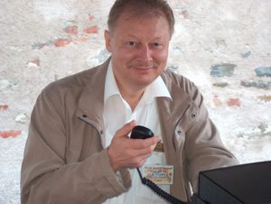 Volker Strecke, DL8JDX (pic taside) informs that next 14th November 2019 in Dresden, Germany there will be an Antarctic Meeting of many Polar Veterans on the occasion of 30th Anniversary of the border opening between former East and West Germany and the later reunification as well as the related impressions from that time at Georg Forster (WAP DDR-Ø1)and Neumayer II (WAP DEU-Ø2) Stations.
 Scott Base (WAP NZL-Ø1) is getting old. Antarctica NZ wants a complete replacement; to dom that plan, Antarctica New Zealand must raise $50 million in charitable donations as part of its $250m Scott Base rebuild.
 Never too late … Let’s once again join the guys in Antarctica in the celebration of Mid Winter!
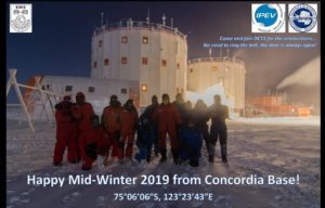 (
(
 June 21, in the northern hemisphere the sun will rise at 5.36 and set at 8.51, remaining in the sky for 15 hours and 15 minutes, while between the Arctic Circle and the North Pole it will not fade at all. The Northern hemisphere will live the longest day of the year.
 Professional news media invited to apply to visit jointly funded US and UK research on Antarctic Thwaites Glacier.The National Science Foundation (NSF) and the International Thwaites Glacier Collaboration (ITGC) are accepting written proposals from media professionals to visit a “deep-field” camp on the remote Thwaites Glacier in West Antarctica in December.
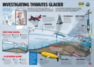 Media will be free to interview Thwaites research teams as they deploy through that camp. A visit to an additional Thwaites Glacier field camp will be highly dependent on weather and logistical variables, and, while possible, cannot be guaranteed.
 Located at 74°20’South, 165°08’ East, Edmonson Point is a rounded, largely ice-free point lying below Mount Melbourne along the west side of Wood bay, Victoria land.
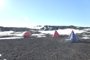 uins and south polar skuas. The site contains a diverse range of freshwater habitats ,terrestrial vegetation and invertebrates are abundant. Weddell seals breed on the adjacent sea ice.
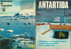 An old collection of Magazines (
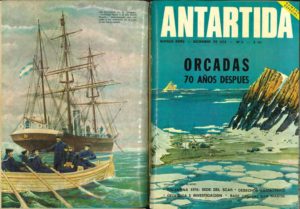 Argentina reaffirms sovereignty over the Argentine Antarctic Sector extending between the 25th and 74th meridians of west longitude, south of the 60th parallel of south latitude.
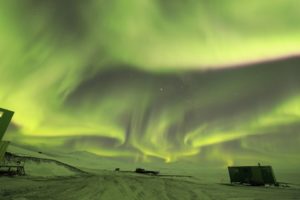 Ross Island turned green in the weekend! This epic shot of an Aurora Australis captured by the winter Leader Jonny Harrison.
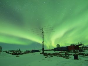 http://www.antarcticanz.govt.nz/scott-base/
 Now the news is official: Icebreaker “Laura Bassi”, former “Ernest Shackleton” of the British Antarctic Survey, is the new OGS ship that will work for PNRA to replace the glorious Italica!
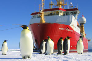
 The Our Lady of the Snows shrine is one of the many memorials atop hills along McMurdo Sound to men who lost their lives in Antarctica; this one is farther up the trail from Hut Point. The Shrine is dedicated to Richard T. Williams, US Navy – Seabees, who lost his life at McMurdo Sound on January 6, 1956 during initial construction of McMurdo Station.
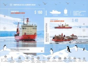 Stamps issued by the Argentine Post Office whose vignettes have designs related with the thematic of the Argentine Antarctic and the Malvinas Islands are always a source of great interest, whether it is a commemoration of special events, expeditions, scientific activities, Antarctic bases, Argentine ships that sail in the Antarctic waters.
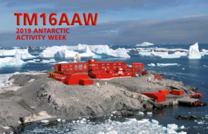 Last Antarctic Activity Week (Febr.2019) has seen a great participation of Hams from several countries WW. Since 16 years, François F8DVD, one of the most active Antarctic enthusiasts, takes part in the event with a special callsign as usual.
 Europe’s dedicated polar-monitoring satellite has produced its sharpest view yet of the shape of Antarctica.
 all. “So, the benefit in the Antarctic Peninsula for example promises to be massive,” says Dr Noel Gourmelen from Edinburgh University and the UK Centre for Polar Observation and Modelling (CPOM).
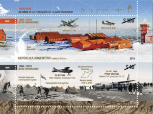 A new postal emission for the fiftieth anniversary of Marambio Base foundation
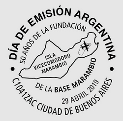
 Bob Hawke maintained that Antarctica was too important to the whole global ecosystem and that mining would always be catastrophically dangerous in that environment …
 Doctor Guillermo Mann Base (formerly Camp Shirreff) is the second of the three research Bases that INACH (
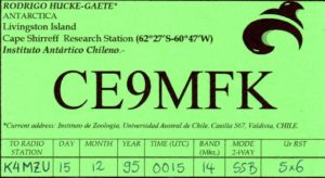 Doctor Guillermo Mann Base (WAP CHL-Ø8) has allowed to generate knowledge in terrestrial and marine biology, and disciplines such as geology and glaciology.
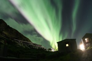 Over the weekend, brilliant auroras lit up the skies above Macquarie Island, (
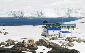 Shirreff Base (official name Cape Shirreff Field Station),is located at 62°28’12” South, 60°46’16” West, on the East side of Cape Shirreff on Joannes Paulus II Peninsula on Livingston Island of the South Shetlands. It’s a seasonal field station operated by the United States, opened in 1996 .
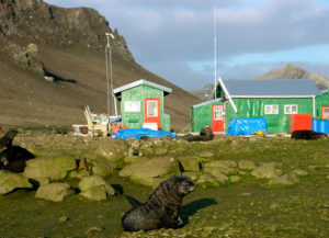 studies at Cape Shirreff field Station.
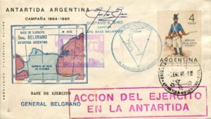 Base Antarctica Belgrano I was located on Piedrabuena Bay on the Filchner Ice Shelf at 77°46’ South, 38°11’ West. At the time of its inauguration in 1954 it became Argentina’s southernmost permanent base. It was shut down in 1980 over safety concerns due to it being built on increasingly unstable ice, which endangered both personnel and equipment.
 On
On 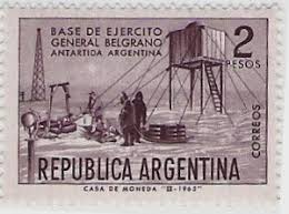 the sea. The unloading of the materials, equipment, tools, instruments and consumables was conducted from ARA General San Martín. The team built a main house, four quonset huts, food stores and hangar. They left on the new base enough fuel for three years.
 As the white continent warms, shrinking sea ice is changing life for
 scientific research in Antarctica. The Alfred Wegener Institute for Polar and Marine Research (AWI) as the national co-ordinator, enables Germany to fulfill this role by its research, long term monitoring and survey activities. It provides the main mobile and stationary infrastructure for Antarctic research, and thus maintains the permanent German presence in Antarctica. The new institute was named after one of the really prominent German polar researchers, who developed the first in-depth ideas about continental drift.
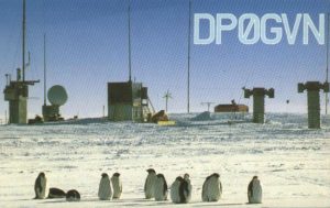 tion. A location on the Filchner-Ronne Ice Shelf at 77°36’South and 50° 40’West was selected as a first choice.
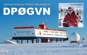 Planned under the supervision of Hartwig Gernandt, Neumayer III Station (70°40’S and 08°16’W)
  Gene Spinelli K5GS (pic aside: Left-Gene K5GS, Right-Steve W1SRD) did respond to the question we put him about next planned South Orkney Expedition. We recall him that: –The 3 locations: Cummings Hut, Foca Hut and Gourlay Huts (
 General Artigas Station (WAP URY-Ø1) is the larger of the two Uruguayan scientific Research Stations in Antarctica, the other one, is Elichiribehety Base (WAP URY-NEW)
 awarded in September of that year with this title by Pope Francis, begins by referring to request that came from people linked to the Artigas Base of Uruguayan Antarctica.
 Windless Bight (77°42’00”South, 167°39’48” West) is the prominent bight indenting the South side of Ross Island Eastward of Hut Point Peninsula.
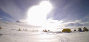 The camp consists of two Polarhavens and six individual mountain tents. The team remains at the field site but will intermittently return one or two team members to McMurdo Station for supplies and overnight stays. The USAP also provides year-round on-site support from a support contractor research associate (RA), who occasionally visits the site during winter months for maintenance and troubleshooting.
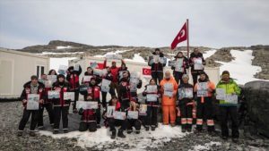 Antarctica, the coldest continent on earth, has served as a scientific research zone since the signing of a 1959 treaty. Recently, Turkey and Belarus signed an agreement that covers scientific cooperation on environmental conservation and study of Antarctic geology; the cooperation on Polar research, happens months after Turkey completed its third National Antarctic Science Expedition.
 One of the
 In 1974 the Antarctic Treaty was signed by East Germany, which reached Consultative Status in 1987. The first permanently operated DDR Research Base, named Georg Forster Station,
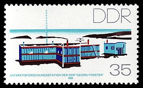
 We must applaud the
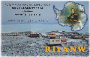

 Matthias, DH5CW, and Felix, DL5XL, have been active from the
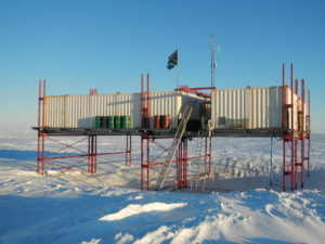
 This is the last one of the three Russian Awards recently issued by DX TROPHY AWARDS GROUP (the other two have been already shown in the previous pages of this website)
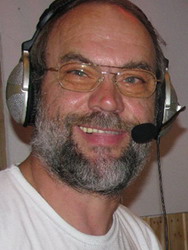 MiKe Luedemann, DL2OE (pic aside), has been in the Argentinean & Chilean sides of Tierra del Fuego (Sub Antarctica) where he has been active for quite a while, in CW and SSB.
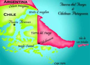 CE8/DL2OE from Karukinka Park, the southernmost National Park in Chile (locator FD55PU),
  April 16th, marks the anniversary of the blessing and inauguration of the oratory of the Chapel at Base Marambio.
 When the ice closed in, the earliest Antarctic expeditions turned to the birds for discovery, meat, and camaraderie.
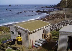
 Green Gorge Hut
 Bauer Bay Hut
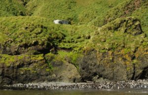 generally open to access from April to August.
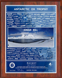 DX TROPHY AWARDS GROUP
 Russia and China have got a joint symposium on March 25th, the first event in a series of meetings the scientists have scheduled.
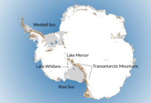 Lake Mercer, 84° 39’ 39” South, 149° 40’ 37” West, is a subglacial lake in Antarctica, that has remained untouched for millennia. Scientists accidentally discovered the lake in 2007.
 “DX TROPHY AWARDS GROUP” issues a new recognition to Hams ho can prove two-way radio communications with the Countries that have Research Stations in Antarctica; this is called
 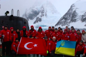 TurkishTeam visits 9 foreign research bases, including Spain, Britain and Russia