We ha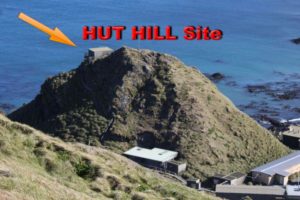 ve learnt something we didn’t know before, and the various point of view have been transformed into certainty. Just to sum up, a revision of Macquarie paragraph on the WAP-WADA Directory will be as follow:
All the calls for which we don’t have details of the operation’s site will be consider as WAP AUS-Ø8, thus:
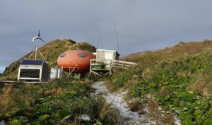
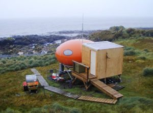
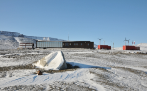
WAP AUS-Ø8 –Macquarie Station will incorporate “HUT HILL” (aka-Ham Shack) & Transmitter Hut (both are 500 mts from the Macquarie’s Station buildings)
WAP AUS-Ø9 – New reference
Brothers Point Hut, Brauer Bay, Macquarie Island, 54°56’ 00” South, 158°52’56” East.
WAP AUS-1Ø – New reference
Waterfall Bay Hut, Waterfall Bay, Macquarie Island, 54°40’29” South, 158°23’37” East
While will not be an easy task to identify who did operate from the several Huts & Refuges scattered around the coasts of Macquarie Island and the dates of each one, te mail of Trevor VKØTH, forwarded on the Antarctic reflector by Mehdi F5PFP was a good surprise. Trevor says: -I operated from the Ham Shack on the hill at the Station, also operated from the Refuges at Brothers Point and Waterfall Bay-.
TNX F5PFP & VKØTH
Now we suggest the Antarctic chasers to check their cards to see if there are some details that will allow WAP to allocate a correct reference to the so many Hamcalls operating from Macquarie in the past and recently.
We kindly ask the operators who have been active at Macquarie to inform WAP by e-mail through wap_info@virgilio.it of the exact location they have been active from.
We suggests the next operators at Macquarie, to mark the location of the operation site on their QSLcards .
Now a brief information on the two new References just issued:
 Brothers Point Hut (WAP AUS-Ø9) is located on the east coast, 8 km south of Macquarie Station. The fiberglass hut, known as a “googie”, provides comfortable accommodation for three people but may fit five in an emergency. It is a popular destination for short duration field trips and is also used as a lunchtime or overnight stopping point as part of longer trips heading down the island.
The hut is accessed from the station via the overland Sandy Bay track, or along the picturesque east coast, when tide and swell conditions allow. The hut is also accessible via inflatable rubber boat, however opportunities to travel on water are typically limited by the weather and availability of suitably qualified boating personnel.
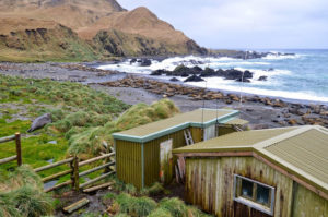
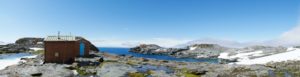
 Waterfall Bay Hut (WAP AUS-1Ø) is another “googie” style fiberglass hut similar to the one at Brother Point. It was installed in 1993-94 as a replacement for the original Lusitania Bay Hut located to the south.
The hut comfortably sleeps three people. As the crow flies, Waterfall Bay Hut is approximately 18 km south of Macquarie Station.
The hut is conveniently located for personnel travelling down island, and is well placed as a research base for the large king penguin colony at Lusitania Bay.
It is easily accessed via the Jessie Nichol track from the north, or the Mt. Martin track from the south. These tracks are subsidiaries of the main north-south overland track.
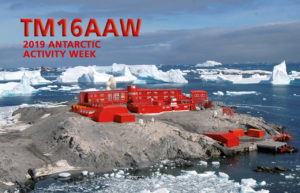 Last Antarctic Activity Week (Febr.2019) has seen a great participation of Hams from several countries WW. Since 16 years, François F8DVD, one of the most active Antarctic enthusiasts, takes part in the event with a special callsign as usual.
 Europe’s dedicated polar-monitoring satellite has produced its sharpest view yet of the shape of Antarctica.
 all. “So, the benefit in the Antarctic Peninsula for example promises to be massive,” says Dr Noel Gourmelen from Edinburgh University and the UK Centre for Polar Observation and Modelling (CPOM).
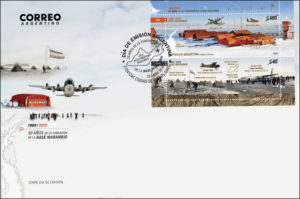
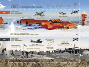 A new postal emission for the fiftieth anniversary of Marambio Base foundation
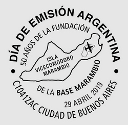
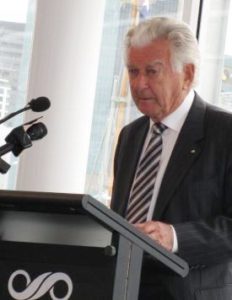 Bob Hawke maintained that Antarctica was too important to the whole global ecosystem and that mining would always be catastrophically dangerous in that environment …
 Doctor Guillermo Mann Base (formerly Camp Shirreff) is the second of the three research Bases that INACH (
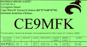 Doctor Guillermo Mann Base (WAP CHL-Ø8) has allowed to generate knowledge in terrestrial and marine biology, and disciplines such as geology and glaciology.
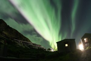 Over the weekend, brilliant auroras lit up the skies above Macquarie Island, (
 Shirreff Base (official name Cape Shirreff Field Station),is located at 62°28’12” South, 60°46’16” West, on the East side of Cape Shirreff on Joannes Paulus II Peninsula on Livingston Island of the South Shetlands. It’s a seasonal field station operated by the United States, opened in 1996 .
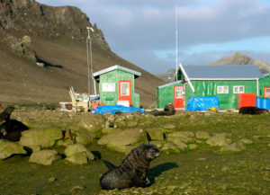 studies at Cape Shirreff field Station.
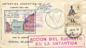 Base Antarctica Belgrano I was located on Piedrabuena Bay on the Filchner Ice Shelf at 77°46’ South, 38°11’ West. At the time of its inauguration in 1954 it became Argentina’s southernmost permanent base. It was shut down in 1980 over safety concerns due to it being built on increasingly unstable ice, which endangered both personnel and equipment.
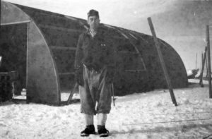 On
On 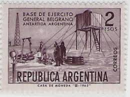 the sea. The unloading of the materials, equipment, tools, instruments and consumables was conducted from ARA General San Martín. The team built a main house, four quonset huts, food stores and hangar. They left on the new base enough fuel for three years.
 As the white continent warms, shrinking sea ice is changing life for
 scientific research in Antarctica. The Alfred Wegener Institute for Polar and Marine Research (AWI) as the national co-ordinator, enables Germany to fulfill this role by its research, long term monitoring and survey activities. It provides the main mobile and stationary infrastructure for Antarctic research, and thus maintains the permanent German presence in Antarctica. The new institute was named after one of the really prominent German polar researchers, who developed the first in-depth ideas about continental drift.
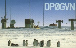 tion. A location on the Filchner-Ronne Ice Shelf at 77°36’South and 50° 40’West was selected as a first choice.
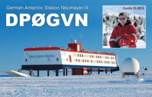 Planned under the supervision of Hartwig Gernandt, Neumayer III Station (70°40’S and 08°16’W)
  Gene Spinelli K5GS (pic aside: Left-Gene K5GS, Right-Steve W1SRD) did respond to the question we put him about next planned South Orkney Expedition. We recall him that: –The 3 locations: Cummings Hut, Foca Hut and Gourlay Huts (
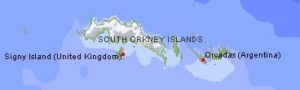
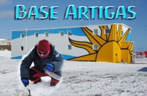 General Artigas Station (WAP URY-Ø1) is the larger of the two Uruguayan scientific Research Stations in Antarctica, the other one, is Elichiribehety Base (WAP URY-NEW)
 awarded in September of that year with this title by Pope Francis, begins by referring to request that came from people linked to the Artigas Base of Uruguayan Antarctica.
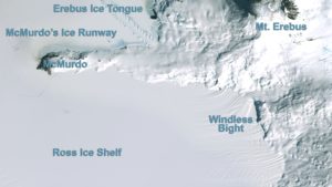 Windless Bight (77°42’00”South, 167°39’48” West) is the prominent bight indenting the South side of Ross Island Eastward of Hut Point Peninsula.
 The camp consists of two Polarhavens and six individual mountain tents. The team remains at the field site but will intermittently return one or two team members to McMurdo Station for supplies and overnight stays. The USAP also provides year-round on-site support from a support contractor research associate (RA), who occasionally visits the site during winter months for maintenance and troubleshooting.
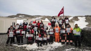 Antarctica, the coldest continent on earth, has served as a scientific research zone since the signing of a 1959 treaty. Recently, Turkey and Belarus signed an agreement that covers scientific cooperation on environmental conservation and study of Antarctic geology; the cooperation on Polar research, happens months after Turkey completed its third National Antarctic Science Expedition.
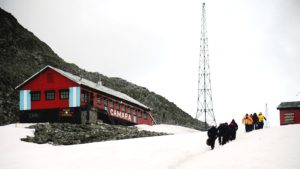 One of the
 In 1974 the Antarctic Treaty was signed by East Germany, which reached Consultative Status in 1987. The first permanently operated DDR Research Base, named Georg Forster Station,
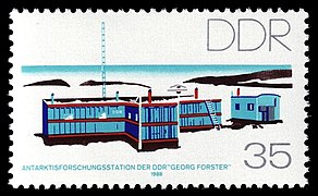
 Pliocene beech fossils in Antarctica, when
  We must applaud the

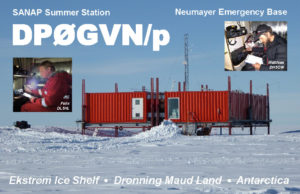 Matthias, DH5CW, and Felix, DL5XL, have been active from the
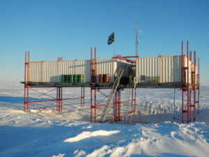
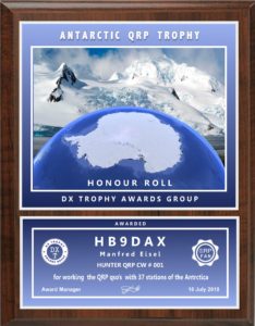 This is the last one of the three Russian Awards recently issued by DX TROPHY AWARDS GROUP (the other two have been already shown in the previous pages of this website)
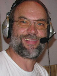 MiKe Luedemann, DL2OE (pic aside), has been in the Argentinean & Chilean sides of Tierra del Fuego (Sub Antarctica) where he has been active for quite a while, in CW and SSB.
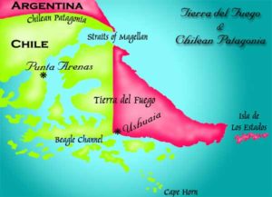 CE8/DL2OE from Karukinka Park, the southernmost National Park in Chile (locator FD55PU),
 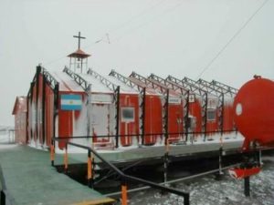 April 16th, marks the anniversary of the blessing and inauguration of the oratory of the Chapel at Base Marambio.
 When the ice closed in, the earliest Antarctic expeditions turned to the birds for discovery, meat, and camaraderie.
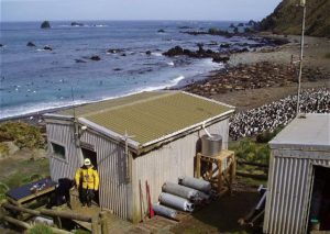
 Green Gorge Hut
 Bauer Bay Hut
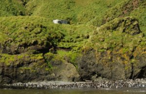 generally open to access from April to August.
 DX TROPHY AWARDS GROUP
 Russia and China have got a joint symposium on March 25th, the first event in a series of meetings the scientists have scheduled.
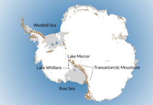 Lake Mercer, 84° 39’ 39” South, 149° 40’ 37” West, is a subglacial lake in Antarctica, that has remained untouched for millennia. Scientists accidentally discovered the lake in 2007.
 “DX TROPHY AWARDS GROUP” issues a new recognition to Hams ho can prove two-way radio communications with the Countries that have Research Stations in Antarctica; this is called
 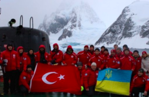 TurkishTeam visits 9 foreign research bases, including Spain, Britain and Russia
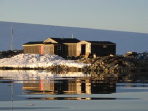 Wordie House (Pic aside) was established by the British Falkland Islands Dependencies Survey on 7 January 1947, on Winter Island (65°15’S, 64°16’W). The hut is named after the chief scientist, Sir James Wordie, geologist on Shackleton’s Endurance expedition of 1914–17 who visited during its construction. The hut stands on the foundations of an earlier building, used by the British Graham Land Expedition from 1935–36. The original hut was destroyed in 1946, possibly by a tsunami.
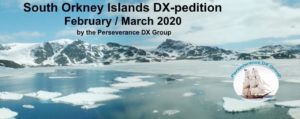 Perseverance DX Group has announced the intention to activate South Orkney Islands, and is planning an expedition to take places in February/March 2020. A team of experienced DX and Contest operators will operate from Signy Island (WAP GBR-Ø9) for up to 15 days. The process of obtaining landing permission is underway. The call sign will be announced at a later date. The team will sail from Punta Arenas, Chile aboard R/V Braveheart. Seven operating positions are planned for 160-10 meters, SSB/CW/Digital.
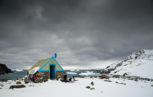 WAP archive has pics of field Huts still in place at the following un-referencended sites of Signy Islands in the South Orkneys:
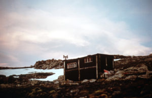
 also has some amazing views, just from the hut across Rock Haven, a popular spot for seals as well as penguins .The Gourlay peninsula 60°44’ South, 45°36’ West, is an ice-free site that guests 2 Huts; the hut on the left is a standard hut with a couple of bunks and on the right is the work hut.
 WAP joins the solidarity with Christchurch shooting victims expressed WW on last 15th March’s tragic day.
 flag was flown at half mast in support of all NZ following the appalling events that occurred in Christchurch.
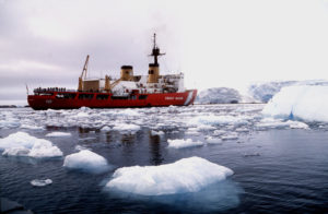
 The Chilean military icebreaker Almirante Viel did transfer everything from Punta Arenas the James Ross Island in 2005. A deep geometric survey was performed as well as the foundations of the main station building and technical containers area. The official opening ceremony took place in February 2007 and made the Czech Republic the 26th Country to have its own Scientific Base on the Icy Continent.
 relaxation and laboratory activities, and of nine technical containers in the vicinity of the building, which hold storehouses, garages and the power supply generator.
 Members of the Argentine armed forces rescued a crew of 13 scientists from the Czech Republic that was stranded in Antarctica, under adverse weather conditions.
 (COCOANTAR), who received the request for rescue from part of the scientific endowment of the Czech Antarctic base .
 To manage the Antarctic WAP Awards and its subsequent updates, the best solution is to use the WAP Software, set by IK6CAC.
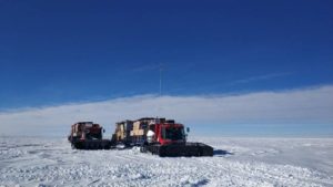
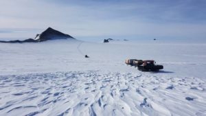
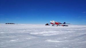 WAP is in contact with Oleg who has sent us pictures and details of the activity from the “Traverse Stop Point –Temporary Field Camp” from where Oleg RI1ANX did operate from 1 through 7 January 20019.
 At the light of the evidence provided by Oleg Sakharov RI1ANX (aka ZS1ANF-UA1PBA) and to the 77 QSOs made from there.
 The British Antarctic Survey has closed its Halley 6 Base (WAP GBR-37) for another winter.
 A question did arise among the Antarctic Ham Radio community about the location of LB4LC whose QSL card seems to say he did operate as /3Y in 1986.
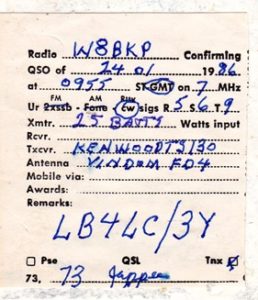
 The National Science Board (NSB) has authorized the National Science Foundation (NSF) to move forward with the Antarctic Infrastructure Modernization for Science (AIMS) project. AIMS is planned as a 10-year undertaking to overhaul McMurdo Station into an energy- and operationally efficient platform from which to support world-class science. Through its Office of Polar Programs (OPP), NSF manages the U.S. Antarctic Program, which funds and facilitates the nation’s scientific endeavors on the southernmost continent and the waters around it. Thanks and Credit NSF.
 oming across a social network, I found an interesting page, set by someone set foot in Antarctica and left a tangible sign of what they did!
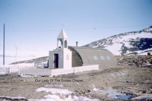 a bell from one of them somehow made its way up the hill to its place in the belfry. On May 6,1956, the Chapel was consecrated to Our Lady of the Snows and the bell consecrated to Saint Dismas, the good thief.”
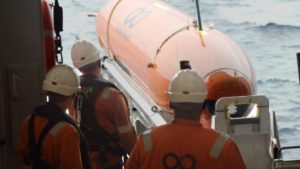 Antarctic hunt for Endurance wreck, ends after expedition loses undersea drone in “evil conditions”
 Acting on the advice of medical experts, National Science Foundation (NSF) officials have directed the NSF-chartered research vessel Nathaniel B. Palmer to put ashore a person in need of a level of care not available aboard the ship.
 115 years of uninterrupted Argentine permanence in Antarctica!
 The link between Belgium and the Antarctic has always been strong since the first overwintering of the scientific expedition led by Adrien de Gerlache from 1897 to 1899, passing through the construction of the King Baudouin Base (
 The Polish Academy of Sciences (PAN) has signed an agreement with Geoscience Australia establishing joint research in the Antarctic. The cooperation between the two countries includes the exchange of scientific thought and technology as well as the exchange of scientific data for the development of maritime and land research on the Antarctic continent. As a part of that agreement, the Polish Antoni Dobrowolski Station is set to be reactivated. Poland has two research stations in the Antarctic: the H. Arctowski Station in the Southern Shetlands, in constant use since 1977, and the Antoni Dobrowolski Station in the Bunger Oasis in eastern Antarctica, which has been unused since 1979.
 The first Polish expedition to the Bunger Oasis in forty years is planned to leave in three to four years with the use of a modern Australian ice-breaker, the Nuyina.