Borchgrevink Huts (WAP NZL-NEW), New Entry on WAP-WADA Directory

Carsten Borchgrevink was a Anglo-Norwegian explorer, best known for being one of the first explorers of Antarctica;  he 
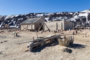
began his exploring career in 1894 by joining a Norwegian whaling expedition, during which he became one of the first persons to set foot on the Antarctic mainland. The first buildings erected by Carsten Borchgrevink at Cape Adare were prefabricated of pine by the Norwegian factory Strømmen Trævarefabrikk. These huts are still standing, and the site is recognized internationally as a significant historic site.

Members of the Northern Party of  Scott TerraNova Expedition overwintered  at Cape Adare in 1911 and 1912. They erected one hut, which has fallen into ruin today.

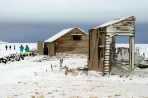
The remains of Borchgrevink’s two huts, as well as those of the Terra Nova Expedition’s hut, have also been designated a Historic Site or Monument (HSM 22), following a proposal by New Zealand and the United Kingdom to the Antarctic Treaty Consultative Meeting. The grave of Nicolai Hanson has been similarly but separately designated (HSM 23).
Expedition’s accommodation hut remains at Cape Adare, under the care of  the New Zealand Antarctic Heritage Trust which acts as guardian to this hut and to those of Scott and Shackleton elsewhere on the continent. The Borchgrevink hut was designated by the Trust as Antarctic Specially Protected Area (ASPA) No. 159 in 2002. In June 2005 the Trust (the highest level of protection available under the terms of the Treaty),  adopted a management plan for its future maintenance and accessibility.


At the light of this evidence, Borchgrevink Huts (ASPA No.159 – HSM 22)   located at Cape Adare, Victoria Land, East Antarctica,  71° 18’ 04” South, 170° 12’ 05” East,  will be add to the WAP-WADA Directory, under NZL-NEW

Plan to tow icebergs from Antarctica to parched Dubai

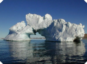
What do you do if you’re a fast-growing city in the desert with lots of thirsty people and little freshwater reserves? Park an iceberg off the coast.

That’s one Dubai-based engineering firm’s plan to provide fresh drinking water to the city’s rapidly-expanding population.

The National Advisor Bureau (NABL), a private engineering firm, wants to schlep a glacial iceberg from Antarctica – weighing approximately 100 million tons – to Dubai, via an intermediate stop in either Perth, Australia, or Cape Town, South Africa.

If the iceberg doesn’t melt along the way, the firm will sell the water to Dubai’s government.

If we succeed with this project, it could solve one of the world’s biggest problems – Abdulla Alshehi, NABL’s founder told NBC News- So if we can show this is viable, it could ultimately help not only the UAE, but all humanity.

Reed more  and watch a video at:

https://www.stuff.co.nz/world/middle-east/106941489/plan-to-tow-icebergs-from-antarctica-to-parched-dubai

The monster Antarctic iceberg A-68 looks finally to be on the move.

For 13 months after breaking away from the White Continent’s long peninsula, the trillion-tonne block did little more than shuffle back and forth on the spot.

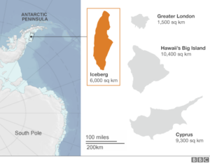
But now its southern end has swung round almost 90 degrees, indicating the berg has been caught in ocean currents.

The approaching southern summer should only assist its anticipated slow drift northwards, experts say.

“After more than a year of moving to and from near its parent ice shelf, iceberg A-68, which calved from the Larsen C Ice Shelf on 12 july 2017, has finally escaped,” commented Prof. Adrian Luckman from Swamsea University, UK.

Until recently, the iceberg was hemmed in by dense sea-ice in the east and shallow waters in the north.  Now, a strong foehn wind blowing eastwards off the ice shelf in early September has pushed the southerly end of the iceberg out into the Weddell Gyre. This persistent clockwise drift of ocean waters and floating sea-ice flowing north past the Larsen Ice Shelf has rotated A-68 out into the Weddell Sea.

“Here, it is much more free to begin moving away and be carried further north into warmer waters.”

Germany’s Alfred Wegener Institute will lead one of the scientific cruises, using the Research Vessel Polarstern; the UK’s Scott Polar Research Institute will lead the other, run off the icebreaker SA Agulhas II.

Read more at: https://www.bbc.com/news/science-environment-45421315

Base Belgrano II (WAP ARG-Ø6)-Capilla Nuestra Señora de las Nieves

In the Argentinean Base Belgrano II (WAP ARG-Ø6), in the Land of Coats, there is a cave carved in the ice. It is the most southern place of religious worship on the planet, only 800 miles from the South Pole. The Catholic Chapel of “Our Lady of the Snows” serves the base throughout the year. Unlike the other temples that appear in this entrance, the Chapel of  Our Lady of the Snows is dug in the ice instead of being a building to use.

The chapel is accessed through a system of tunnels in the subsoil, built to facilitate the movement of the resident personnel and scientists that works at  Belgrano II Research Station (WAP ARG-Ø6).

Pedro Sarli LU1JHF, sent a link where (in spanish language) you can read the history of Base Belgrano I since the fist inauguration on 18 January 1955 and see lots of pics of this fantastic ice carved chapel.  After an activity of 25 years, the old base General Belgrano (WAP ARG-Ø5) was inactivated. In order to continue the scientific programs and maintain the Argentine presence in the area, on February 5, 1979, the Belgrano II Base was founded as a replacement.
Click on the link below and enjoy the history:

CAPILLA ANTÁRTICA (BASE BELGRANO II) SECTOR ARGENTINO DEL ANTÁRTICO ⛪HOGAR DE LA IGLESIA CATÓLICA EN EL EXTREMO MÁS AUSTRAL DEL MUNDO. HISTORIA LA BASE BELGRANO II.

Pic here above shows the inside view of the ice carved Chapel; belows its the entrance!

TNX LU1JHF


As our readers know, WAP is collecting information and pictures to document what important is, for the people in Antarctica, to have a place to pray Lord, an holy place to free one’s spirit and thank Lord for his magnificence.

In the year 2003, WAP did propose to the italian authorities build a little Church at the Italian Base “Mario Zucchelli Station” at Terra Nova Bay… our proposal is still alive waiting the wall of bureaucracy to fall down!

ZL5A Scott Base (WAP NZL-Ø1) Antarctica

Adam Campbell ZL4ASC says he will operate for  13 months at  Scott Base (WAP NZL-Ø1) signing ZL5A. His schedule is to be at Scott Base on Ross Island, over the 2018-2019 Antarctic season. More info to follow.

Adam said: Please note I will be working on critical communications equipment and can only operate as an amateur in my spare time.

Adam has a website at: https://www.adamcampbell.co.nz/

In a recent mail, Adam wrote: Hi Gianni, I am hoping to contact a large number of stations whilst on the ice, yourself included.

I am very busy collecting equipment and training for my deployment, and once I have left NZ I will be able to focus more on my ham radio stuff. Thanks for your interest and I look forward to speaking with you soon.

TNX ZL4ASC/ZL5A


Just to remind the readers that New Zealand holds 3 WAP reference numbers in Antarctica for as many bases as listed on the WAP Directory:
WAP NZL-Ø1  Scott Base

WAP NZL-Ø2  Swan base

WAP NZL-Ø3  Worldpack Base (Greenpeace Station), plus about 21 New sites (WAP NZL-NEW) Field camps, Huts, Stations and Refuges.

On Ross Island, there is another brand New one (picture below): The Arrival Heights Laboratory (WAP NZL-NEW) which houses equipment for atmospheric experiments, low frequency radar and aurora studies for universities and other research groups.


Let’s hope Adam might have a chance to go up there and give the Antarctic hunters the chance to log this “New one” … let’s keep our finger crossed, let’s  hope!!!


Historical still standing Huts from the Antarctic Heroic Age 1897-1922

The first overwintering hut was erected in Antarctica  at Cape Adare in 1899 by the British Antarctic Expedition led by Carsten Borchgrevink.

It was a large wooden structure supplied as a kit for speed and ease of erection, it was the first time a building had been erected on Antarctica, perhaps surprisingly it still stands and so is the only remaining example of a surviving first building on any continent.

It set the pattern for Antarctic buildings for the next fifty years or so of wooden huts designed to be erected quickly during a short summer season that will at some time be interrupted by adverse weather conditions.

While the buildings were only needed for 2-3 years at most, they had to be very strong and sturdily placed to withstand the relentless onslaught of the elements.

Along with cold temperatures in Antarctica resulting in a slow rate of decomposition of the wood the huts were built from, this means that there are a number of huts that are still in existence today in pretty good condition, considering their age.

Shortly we’ll report about some new Huts not yet listed on WAP-WADA Directory; they will enter on WADA next release

TNX and credit to: www.coolantarctica.com

Read more about Huts in Antarctica at: https://www.coolantarctica.com/Travel/antarctica-huts-historic.php

VKØHZ – Davis Station (WAP AUS-Ø3), Antarctica

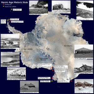
Matthew Gledhill,  VK5HZ from a page set at QRZ,com  informs that during the Antarctic summer 2018-2019 and  Antarctic winter 2019 he will be working at Davis Station (WAP AUS-Ø3) signing VKØHZ.

Matt will be there 12 months and now says: – Note this is not a DXpedition and any radio activity will be in my downtime. More details of my operation and station setup to come late 2018-.

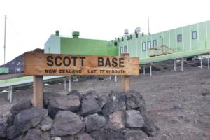
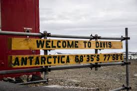
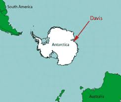
Davis Base is the most southerly Australian Antarctic Station and is situated 2250 nautical miles South-South-West of Perth, on the coast of the ice-free Vestfold Hills, Ingrid Christensen Coast of Princess Elizabeth Land, East Antarctica, in the Australian Antarctic Territory at 68° 34′ 36″ South, 77° 58′ 03″ East, Grid MC81xk

Davis Station officially opened on 14 January 1957; a small ceremony was held to mar
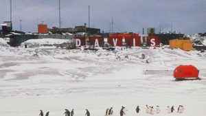
k the event. The Base was named after Antarctic legend, John King Davis, captain of the ships Aurora (1911–14) and Discovery (1929–31).  used by Douglas Mawson on his expeditions.

In January 1965, Davis was temporarily closed to concentrate resources on building Casey Station (WAP AUS-Ø2).

Davis was reopened on the 15th February, 1969 and has operated continuously since.

TNX VK5HZ/VKØHZ

VP8WA, Mr. Peter Short is SK

Written by Anthony W.DePrato WA4JQS

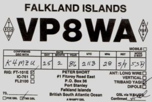
With sincere regret, we learn that Mr. Peter Short VP8WA of Port Stanley, Falkland Islands, became a SK 2 weeks ago.

Peter was a member of the South Sandwich Island DX Group. Peter was very hard working helping with our 1992 #1 Most Wanted DXPED VP8SSI and again in 1994 with our #1 most wanted DXPED 3YØPI to Peter the First Island.

Peter also helped later dxped’s going to South Sandwich ,South Georgia, and Peter 1st. He was the first and only RTTY QSO for many hams from the Falklands. Peter along with Marshall VP8PU and his XYL Dee VP8QG were for many during the 70’s, 80’s and 90’s the only VP8 QSO’s.

Sadly they are all now QRT for the most part. Bob VP8LP who also helped with all the SSI-DXG and later dxped’s is now the only active Ham in Stanley for the most part.

I was the QSL manager for all,  but Bob VP8PL and still have the logsfor the following VP8’s: VP8PU, VP8QG, VP8WA, VP8ZV, VP8NJ, VP8QJ and VP8BZL.

Tony WA4JQS / VP8BLZ, Anthony W.DePrato WA4JQS since 1962

Cq Dx Hall Of Fame # 35, Dxcc Honor Roll, Dxpedition Of The Year 1992 VP8SSI.  Dxpedition Of The Year 1993/1994 3YØPI.

Calls held: VP8SSI, 3YØP,I VP8BZL, V31SS, ZD8JQS, WA4JQS/ZS1, WA4JQS/KC4, WA4JQS/4K1

TNX WA4JQS / VP8BLZ & Maxi, DL-SWL

Earthquake Strikes South Shetland Islands

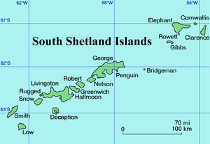
Monday 27 Aug at  20:09:24  a moderate magnitude earthquake at a depth of 64.0 km in open waters did strike the South Shetland Islands, Antarctica. Epicenter latitude/longitude was 61.85° South, 58.5° West

The earthquake was felt also at the Korean King Sejong Station (WAP KOR-Ø1) and  in the Chilean Antarctic Base Pres. Eduardo Frei Montalva-Villa Las Estrellas (WAP CHL-Ø5),  54 km SW from epicenter.

Comment from the personnel overwintering at Arctowsky Polish Antarctic Station (WAP POL-Ø1) was: today between wind gusts we felt something new; – an earthquake measuring 5.6 on the Richter scale-.

Details at: https://www.earthquaketrack.com/r/soth-shetland-isl…/recent

Antarctic community mourns loss of science leader

The Australian Antarctic Division has paid tribute to a former Chief Scientist, Professor Patrick (Pat) Quilty AM, who died on Sunday (26 August). Professor Quilty led the Division’s science program for more than 18 years from 1980–1999 and published more than 200 scientific papers.

The Australian Antarctic Division said long-serving former chief scientisProfessor Quilty died at the weekend at the age of 79.

After graduating in 1962 with a Bachelor of Science with honors from the University of Western Australia, Professor Quilty first visited Antarctica in 1965 as a field palaeontologist with the University of Wisconsin.
He received his PhD from the University of Tasmania in 1969.
AAD director Nick Gales said Professor Quilty had made an outstanding 
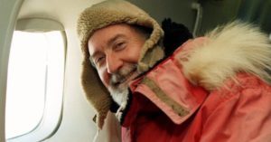
contribution to Antarctic science.


WAP sends personal heartfelt sympathies on the loss of Prof Pat Quilty to his family and to the whole AAD.

Global warming, a matter to be worried about!

Thanks to our HAM friend Juan Manuel Pereda LU4CJM,  this post reflects the  worries that rise to world level!

What we can do, is to share this and hope that something can change before it’s really too late.


Approximately 54 billion tons of greenhouse gases are emitted each year, mainly from the burning of fossil fuels.
The UN believes that these emissions should be reduced to 42 billion tons by 2030 to curb global warming below 2 degrees.

Women in science setting sail for Antarctica

Three University of Queensland researchers are among a group of 100 female scientists from around the world taking part in a year-long leadership scheme culminating in an Antarctic voyage.
They are part of the fourth group selected for the prestigious Homeward Bound program, which aims to create a global network of women in science who can influence policy and decision making.
The Institute for Molecular Bioscience’s Dr Anna Vinkhuyzen and Hana Starobova and Dr Emma Kennedy from the Global Change Institute have teamed up with fellow Queenslanders, Bianca Das and Karen Aitken from CSIRO, to raise funds for the trip.
A three-week trip to Antarctica is the summit of a year-long journey, where the participants explore leadership, strategy, and how to extend the reach of their science message through virtual meetings and an online curriculum. The Queensland scientists will work and learn with colleagues from across the globe, despite their diverse research interests.
The fourth ship sails from Ushuaia, Argentina on 19 November 2019 and will visit several different research stations in Antarctica.
Read more at: https://www.uq.edu.au/news/article/2018/08/women-science-setting-sail-antarctica

Bellingshausen Station (WAP RUS-Ø1) – Rainbow above the Trinity Church

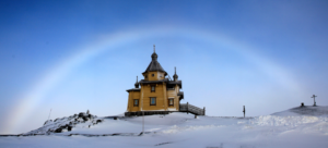
Spring is coming in Antarctica; rainbow above Holy Trinity Church at Bellingshausen Station (WAP RUS-Ø1), King George Island; world’s southernmost Russian Orthodox church.
Correction from Wessex Weather: it’s probably not a rainbow because it doesn’t appear to be raining; more likely a fogbow or cloudbow (some navigators call them white rainbows).
Photo: Vitaly Boldin, AARI

Thanks and credit: https://www.facebook.com/TheAntarcticReport/photos/a.906628919420995/1756443784439500/?type=3&theater

San Diego Scientists to use drones in Antarctica Research

National Oceanic and Atmospheric Administration scientists have tracked krill populations in the southern oceans for years, but for the first time, they plan to use autonomous computer-driven drones to help with the basic research.

Krill are tiny crustaceans that are a key building block of the food web in the southern oceans. The shrimp-like creatures feed whales, seals, penguins and people. The tiny animals are known for their large underwater swarms.

NOAA scientists have tracked fluctuating krill populations for years as part of an international effort to better understand the food web in the Antarctic.

Click on the gif aside to see an interesting video of this project.
“We study krill so we understand whether its trends and abundance are likely to be influenced by how much fishing effort we do, but also whether that fishing effort will impact the upper trophic levels like penguins and seals,” said Christian Reiss, a senior researcher at the Southwest Fisheries Science Center in La Jolla.

But packing up a research vessel and traveling to the bottom of the world takes time and money. Both are in short supply at a federal agency that is keeping a close eye on shrinking budgets.

Thanks and credit to: https://www.kpbs.org/news/2018/aug/16/san-diego-scientists-use-drones-antarctica-researc/ where you can get more

Italy – A day of National mourning

WAP  joins the day of National mourning for the victims of the collapse of the Morandi highway bridge in Genoa.

Inaugurated in 1967, the Morandi viaduct served as the main East-West artery linking Genova and the entire southern Mediterranean. It was a key logistics point for trucks loading and unloading containers in Italy’s biggest gateway port, as well as the heavy car traffic towards different higways.


On 11:36 Tuesday morning, August 14th, the towering concrete icon of national pride collapsed into a jagged heap, swallowing carloads of innocent passersby, crushing the dreams of dozens of families leaving the whole country upset


Our sympathy and our deepest condolences to the families of the victims.

Fossil Bluff Field Station, Alexander Island, Antarctica – WAP GBR-1Ø

Fossil Bluff lies at the foot of a scree-covered ridge overlooking George VI Sound, which separates mountainous Alexander Island from Palmer Land.This small base located at 71° 20′ South, 68° 17′ West, was established on Alexander Island in 1961 with the purpose of Survey, geology, glaciology and field geophysics. This advanced station, occupied during the winters of 1961, 1962, 1969-75, supplied overland for field parties from Stonington Island (Station E) WAP GBR-Ø5, Adelaide  (Station T) WAP GBR-13, and Rothera (Station R) WAP GBR-12. It was closed for the 1976 winter when Rothera (Station R) became fully operational, and now is  a forward logistics facility with skiway

Fossil Bluff it is about 225 miles south of Rothera, with summer-only occupation since 1975, the bluff is a collection of 
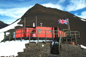
buildings and facilities, at the centre of which lies the main hut, named Bluebell Cottage, houses four people in comfort and forms a transit station for summer field parties
The base is operated by Twin Otters from Rothera station (90 to 110 minutes flight)  during the Antarctic summer season as forward fuel depot, facility for re-fuelling aircraft and field station for parties from Rothera (Station R) during austral summers. Site was cleaned-up by BAS during the 2002/03 and 2003/04 seasons.

A 1,200 metres unprepared snow runway (skiway) marked by drums is located 1km south of the station.  During the Antarctic summer months a small team provides weather forecasting information for flight safety

Snipe Island, Chilean Navy outpost and Meteorological Station WAP CHL-NEW

The Snipe island  54 ° 57′ South,  67 ° 9′ West  was involved into a military incident that took place between Chile and Argentina during 1958 as a result of a disputed border line in the Beagle Channel for the possession of that islet.

Snipe Island, located a mile from Navarino, is a small rocky formation with sparse vegetation that was occupied by an indigenous Yahgan from that island, authorized by Chile to graze sheep in it.

On January 12, 1958, the Micalvi cutter of the Chilean Navy, based in Punta Arenas, built a blind beacon on the Snipe island, on the Beagle Channel, as an aid to navigation and on May 1 of the same year, the Patrolman Lientur was commissioned to install a luminous beacon on its structure, giving the corresponding international warning to alert sailors to its existence.

The fate of Snipe islet has since been settled by the Treaty of Peace and Friendship of 1984, as an internationally recognized territory of the state of Chile.

There is now a lighthouse (WAP CHL-LH-NEW) on the islet. The Treaty of Peace and Friendship of 1984 between Chile and Argentina was signed into agreement at the Vatican on 29 November 1984.

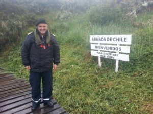
Actually,  on this sub-Antarctic site there is a Navy outpost, a Meterological Station  and a Lighthouse.


Who knows if one day, some willing Radio operator or one of the Chilean Radio Clubs will try to activate this rare DX spot … ee would be happy and proud to Log a DXpedition from Snipe Island!

Polar Challenge 2018 by the French Polar Team

The 2018 results of  Arctic Challenge , Antarctic  Challenge , Polar Challenge ( Arctic Ch + Antarctic Ch ) are available online via :
http://french-polar-team.fr/Polar_Trophy_files/Polar%20Trophy%20Scores.pdf , where the full list can be seen

About Antarctic Challenge the 1st 20 Hams on the 2018 list are:


The French Polar Team’s website (http://french-polar-team.fr ) is dedicated to amateur radios and Short Waves Listeners (SWL) fascinated by Polar and Sub-Antarctic Rregions.


Mehdi F5PFP  and Michel F6DWQ have created the Polar Trophy in the  aim  to stimulate the radio contacts with these regions as well as with the Polar ships. This challenge is subdivided in the Antarctic Challenge and the Arctic Challenge.

TNX  Michel F6DWQ & Mehdi F5PFP for the great job!

3G9JA Hornos Island, WAP CHL-2Ø

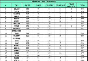
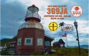
Just to resume the article of last  August 1st (the 2016 operation from Hornos Island WAP CHL-2Ø), we are happy to show the QSL of 3G9JA just received by Bob K4MZU, who said:  –Good news….very happy today I received QSL confirmation from Dagoberto CE5COX for 3G9JA-.

Another rare one to add  to the WAP QSL Gallery.

It ‘s getting hard to work new sites in Antarctica  or Sub/Peri-Antarctic areas but for time to time something new is coming on the air, and let’s say, those are real DX!


TNX Bob Hines KI4MZU

Today on all Australian Antarctic Stations flags are flying at half mast

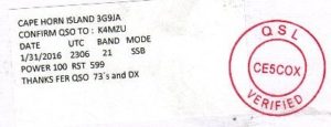
Today on all Australian Stations flags are flying at half mast in honour of Geoffrey Reeve who passed away at Casey in 1979. ( pic aside shows Casey Cross at Reeve’s Hill)

Geoffrey Basil Reeve, was the first Casey expeditioner to die while serving in Antarctica; he died of exposure and hypothermia in 1979 during a blizzard.

August 1979 at Casey Base, Antarctica: Geoffrey Reeve died of exposure after he became lost in a blizzard 10km from Casey. He was the senior electrical fitter-mechanic at the station, and deputy officer-in-charge. Early in August Mr Reeve was one of six members of the winter party who camped at Robinson Ridge, a rock out-crop about 10km from Casey, to undertake maintenance and biological observations. On August 5 he was moving in the camp precincts when he was caught in a sudden blizzard which reached a speed of 96 knots. Other members of the party found Geoffrey Reeve unconscious less than a kilometre from the camp. A search and rescue team, including the medical officer, Dr K. de Jonge, was sent from Casey by tractor, and brought Mr Reeve back to the station. Further resuscitation attempts were unsuccessful. Mr Reeve’s family asked that his body be returned to Australia for burial. It will be flown out from Casey on one of the two flights which a United States Navy Hercules will make from McMurdo Station in the first week of November.

Source: https://antarcticsociety.org.nz/wp-content/uploads/2017/07/Antarctic.V8.11.1979.pdf

The Jesuits and their important presence in Antarctica

In spite of the famous saying “below 40 degrees South there is no law; below 50 degrees South there is no God” the exploration of the continent was in fact closely connected to religious activities Jesuit  geophysicists. Some of the early religious buildings are now protected as important historical monuments. Antarctica has various places of worship and an increasing demand for religious services and construction of sacred architecture on the Continent

Jesuit is the largest single order in the Catholic church, with more than 19,000 members by its own count, and a presence on every continent  including Antarctica, where Jesuits have been chaplains and, in keeping with their order’s reputation as the church’s intellectual powerhouse, even scientists. Jesuits have a 60 year history in Antarctica. In 1951 a 27 year-old French Jesuit scholastic (seminarian) and here below are some of them:

Rev. Pierre-Noël Mayaud (1923-2006), was one of 17 scientists who sailed on the polar exploration ship Commandant Charcot to spend 12 months at  Adelie land, the French sector of Antarctica.  Mayaud had become a Jesuit in 1941 at the age of 18. Permission for him to join the Antarctic expedition was given by Fr.  Jean-Baptiste Janssens, who was at that time the Superior General of the Society of Jesus, because it was believed that the experience he gained in Antarctica and the scientific work he did there would be a great asset in his future work as a professor at a Catholic university. Later in his life Father Mayaud, a geophysicist, was member of Conseil National de la Recherche Scientifique (CNRS). See:  https://antarcticjesuit.com/2013/01/04/french-jesuit-in-antarctica/


The Rev. Edward C. Bradley (* 18 july 1928, +8 june 2011, aged 82), was a Philadelphia physician who became a Jesuit priest when he was 50  In June 1979, the month before his 51st birthday, he was ordained as a Jesuit priest. for 18 years, Bradley had been one of the University’s most ambitious and adventurous Jesuit scientists, operating a state-of-the-art seismology station and challenging students in the classroom, all the while regaling everyone with stories of his adventures—particularly of his trip to Antarctica and his explorations at the bottom of the world


Father Michael Smith Australian Jesuit, visited the South Pole in December 2012 when he was a chaplain to the US base in the Antarctic (pic aside).


Father Dan Doyle (1932-2014) has been the leader of New Zealand’s Antarctic Ministry for the past 15 years, spending 14 summers at the Antarctic base as priest to a maximum summertime population of 2,000. In the winter, when the Antarctic falls dark, the population drops to about 150 essential staff.

Horn Island Meteo Station WAP CHL-2Ø

Located at 55° 56’ 50” South, 67° 18’ 15” West, Horn Island Meteo Station did enter the WAP-WADA Directory as WAP CHL-2Ø, following the operation of  3G9JA operated in February 2016 (see http://www.ce5ja.cl/expedicion-cabo-de-hornos/ ) The original preview callign XR400JA have been changed to 3G9JA operated by Dagoberto, CE5COX who was QRV  40-20-10m, SSB/RTTY. QSL via CE5JA.

That one, was a Special activation for the “Anniversary of the Discovery of Cape Horn (1616-2016)
The Chilean Navy maintains a station on the island, consisting of a residence, utility building, chapel, and lighthouse. A short distance from the main station is a memorial, including a large sculpture featuring the silhouette of an albatros, in honor of the sailors who died while attempting to “round the Horn”.

The island is one of the Hermite Islands, part of the Tierra del Fuego archipelago. Two lighthouses are located near or in Cape Horn. The one located in the Chilean Navy Station is the more accessible and visited, and is commonly referred to as the Cape Horn lighthouse. However, the Chilean Navy station, including the lighthouse (ARLS CHI-030, 55° 57’ 48” South, 67° 13’ 12” West) and the memorial, are not located on Cape Horn (which is difficult to access either by land or sea), but on another land point about one mile east-northeast.

A video show some very interesting views of this Island is available by clicking the red button aside.

Before it was a detachment of three Chileans who are part of the Chilean Navy, those who took care of the facilities and gave sovereignty to this mythical point of the world navigation. Now who is in charge of the lighthouse and the weather station is a single military man, who must reside on the island for a year with his family. The island of Hornos can only be reached by private boat, with the Chilean navy or in one of the two cruises that make the route of the Patagonian channels or that travel towards Antarctica.

Let’s hope the Chilean Radio Club or some Chilean operators can do it again in  the near future, Horn Island is always a great DX!

RI1ANW Novolazarevskaya Station, WAP RUS-Ø9

Alex RN1ON informs that Sergey V. 
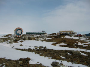
Timofeyev, R3IW will be active on HF Bands mostly on Digi modes as RI1ANW from Novolazarevskaya Station (WAP RUS-Ø9), Antarctica, until March 2019 together with RI1ANL (operated by RW6ACM).

Alex  says that Sergey, R3IW (ex.call-sign RW3IW) was not very active, so there is no information of his new callsign on QRZ.com. Sergey’s callsign RI1ANW for Novolazarevskaya was just issued  on last  July 23.

Please note that at the beginning of 2018, Sergey R3IW made 30-40 QSOs signing RI1ANF operating from Novolazarevskaya Station, Antarctica (not from Bellingshausen Base WAP RUS-Ø1), so make sure to eventually allocate RI1ANF (2018) to Novolazarevskaya not to Bellingshausen.


QSLs for  both callsigns RI1ANL and RI1ANW and few of those QSOs as RI1ANF (2018) must be requested only to RN1ON, ClubLog OQRS.

Direct requests via RN1ON:
Alexei V. Kuz’menko, P.O. Box 599, 163000, Arkhangelsk, Russia

TNX Alex RN1ON

Reginald J. Beck, VE7IG, SK

WAP has just got the sad news of VE7IG SK.

Reginald J. Beck VE7IG (VE1DXA) passed away on July 24. First licensed as VE7ANI the day of his 18th birthday in June 1956.

Reg was a great DXer and one of the most active Antarctic Hunters; he did share his huge Antarctica QSL collection with us;  his ancient and precious QSL cards are loaded  into the WAP Antarctic QSL Gallery

We keep a fantastic recall of Reg when long ago (1991) he did  join us for the 1st IOTA Meeting held in Loano Italy. Reg was guest in our houses and we spent a wonderful time together.

The pictures show some of that moments. (pic above, L to R: Gianni I1HYW, Yuki, JI6KVR, Max IK1GPG, Betty IK1QFM and among us Reg, VE7IG)

The pic below, shows L to R: EA5KB, CT4NH, IK1GPG, I1BSN,  IK1HSS and the good friend Reg VE7IG.

The Antarctic Community have lost one of his best guys, a professional Ham, a very skilled operator and a real good friend, always ready to help.

Reg is holding WAP WACA & WAP-WADA Top Honor rolls with 334 Antarctic callsigns (WACA) and 139 Bases worked (WADA)


Rest in Peace Reg, we’ll never forget you.

On behalf of the Hams and Antarctic Community, our deepest condolences to his family

Antarctic expedition hopes for Ernest Shackleton bonus

A scientific expedition will next year try to find the Endurance, the ill-fated ship of Antarctic explorer Sir Ernest Shackleton.

The vessel sank in 1915, crushed by sea-ice in the Weddell Sea and lost in 3,000m of water.

Shackleton and his crew were forced into lifeboats to make an extraordinary and heroic escape across the Southern Ocean.

UK researcher Prof Julian Dowdeswell will lead the international effort.

He expects to have the cruise on station in January/February.

Locating the shipwreck is not the primary goal of the expedition; the major objective is to visit and study the Larsen C Ice Shelf, which last July calvedone of the biggest iceberg ever recorded in Antarctica.

Source: https://www.bbc.com/news/science-environment-43703723

Whaling stations of Stromness Bay (WAP GBR-NEW) and Husvik (WAP GBR-27)

Three, are the  abandoned whaling stations in Stromness Bay, South Georgia. The stations are closed to visitors because of their dangerous state, including contamination by asbestos. The sub-Antarctic Island of South Georgia had five main shore stations at the height of whaling in the early 1900s. The last of them closed in the mid 1960s. This clip is attached to the monthly website newsletter on www.sgisland.gs

Stromness Station (WAP GBR-NEW). No one has been active “On the air” so far, from there

Husvik Station (WAP GBR-27) 54°15′ South, 36° 45’West;  as far as we know, Hams been active from this site are:

VP8MS in the year  1976

VP8GEO in the year 2002

VP8DIF in the year 2008-2009


There was a recent operation VP8SGI in the year 2016 that sets tents a little away the formal Husvik Station; we called it Husvik Base Camp (57° 10′ South, 36°40′ West); to this site, a new WAP reference GBR-39 has been given

Lame Dog Hut at St. Kliment Ohridski Base  (WAP BGR-Ø1)

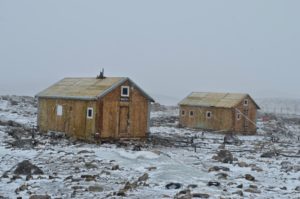
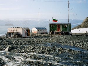
The Lame Dog Hut was erected in April 1988, at 62° 38′ 29″ South, 60° 21′ 53″ West and had been the main building of St. Kliment Ohridski Base until 1998.  It is presently the oldest preserved building on Livingston Island, used as radio shack and post office, and hosting a museum exhibition of associated artefacts from the early Bulgarian science and logistic operations in Antarctica.

The Bulgarian Antarctic Base “St. Kliment Ohridski” (BAB)  in the eastern part of  Livingston Island, South Shetland Islands,  is located on the Bulgarian beach, Emona Harbour, East – Northeast of Hesperides Point (Latitude:  62°37’59” South, Longitude: 60°20’59” West) at the Eastern Coast of the South Bay, Livingston Island, South Shetlands.
A Post Office operates at St. Kliment Ohridski Base  since 1995.

The site elevation being between 12 to 15 m above sea level. The site is particularly appropriate for an Antarctic settlement and the existence of the BAB  has a minimum negative impact on local wildlife, for Bulgarian beach has fairly modest population of penguins and seals. At the same time, the base location offers most convenient access to Mount Friesland, Burdick Ridge, Mount Bowles, southern Hurd Peninsula and Varna Peninsula areas .


There is now a proposal for a new Historic Site or Monument (not previously designated as an HSM by the ATCM) for Lame Dog Hut.

Being part of the Bulgarian St. Kliment Ohridski Base (as shown on the pic above), Lame Dog Hut is included in the WAP BGR-Ø1 and a new WAP refence to it  will not be given.


LU4ZS Base Marambio (WAP ARG-21) “On air” by LU4CMF

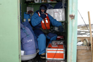
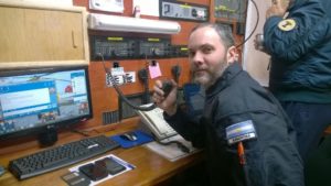
Hereby  a couple of pics of Cristian Mauro Fabregat, LU4CMF, operator at Marambio Base as  LU4ZS in a site with -50ºC and 100 km/h of Antarctic wind.

LU4ZS is actually the solo station active from Marambio Base, while on the several Argentinean Stations in Antarcticano one is QRV. 

We must plaude Cristian and we have to thank him  to still believe in the power of the Ham Radio and in the heart of Radio Amateurs.
We really hope that Argentine Authorities can encourage the use of Amateur Radio bands in Antarctica to not dissipate the cultural heritage that Ham radio has been able to create in the international community since the last century.

Thanks Cristian you’re doing great!

QSL via LU4AA, Radio Club Argentino
P.O. BOX 97
Ciudad de Buenos Aires, C1000WAA, Argentina


TNX LU4AA, LU4CMF/LU4ZS and LU4CJM

From the Antarctic ice, the discovery of the first extragalactic source of neutrinos

IceCube can tell the direction of some neutrinos to better than a quarter of a degree. It consists of a billion tons of diamond-clear Antarctic ice about two kilometers deep, monitored by more than 5,000 light detectors. In 2013 it detected the first high-energy neutrinos coming from beyond 
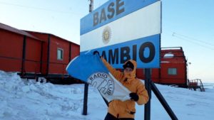
our atmosphere. But that breakthrough was not entirely satisfying because those neutrinos had rained in uniformly across the sky: There was no indication of the specific objects that may have emitted them—no “point source.”

This past September IceCube detected a neutrino carrying about 20 times the energy of any particle that could possibly be created by the most powerful man-made accelerators. This meant it had probably come from outer space.

The instrument broadcast an automated alert.

IceCube’s alerts generate a lot of interest among astronomers, because the neutrino represents the third arrow in the quiver of the newborn field of multimessenger astronomy.  Astrophysicists have long dreamed of employing messengers besides light to reveal the inner workings of the many unfathomable wonders in the cosmos. And the dream had come true only one month earlier, when three gravitational wave observatories had detected the merger of two neutron stars and optical telescopes had tied that merger to a gamma-ray burst: a brief flash of the most energetic form of light. No neutrinos were seen, however.

Source: https://www.scientificamerican.com/article/neutrinos-on-ice-astronomers-long-hunt-for-source-of-extragalactic-ghost-particles-pays-off/

Chilean facility in Antarctica destroyed in fire

The headquarters of the Chilean Maritime Authority in Antarctica, located in one of the buildings of Base Arturo Prat (WAP CHL-Ø1) was destroyed by fire today, Thursday, July 12, 2018. The Maritime Government is the agency of the Navy that aims to support maritime traffic, collaborate in search and rescue actions, control pollution, support evacuation actions, among other tasks.

The Chilean Antarctic Institute (INACH) deeply regrets the fire that during the early hours of Thursday, burned out all the whole installation  of the Chilean Antarctic Maritime Administration, administered by the Chilean Navy, on King George Island.
According to Foreign Minister Roberto Ampuero, thanks to the emergency work, the 10 people employed  there,  were unharmed. For the moment, they are in good health and has already offered accommodation in the Scientific Base “Professor Julio Escudero” (WAP CHL-Ø7); for now, they are being supported by staff of the Eduardo Frei Montalva Base, (WAP CHL-Ø5) of the Chilean Air Force.
The INACH will send personnel to the area as soon as possible to evaluate the conditions of the Escudero Scientific Base, adjacent to the Maritime Governance. The collaboration between both bases allowed to give viability and safety conditions to the maritime activities of the Antarctic Scientific Expedition. The Bases of the INACH and the Maritime Governance shared since 2011 the use of a sewage treatment plant in order to meet the environmental commitments derived from the Madrid Protocol. The viability of its use should be defined with urgency, since Base Prof. Julio Escudero  represents the main Chilean scientific base, with more than 250 scientists passing through it every summer season.

The Navy has been present in the Antarctic territory since 1957, initially with the base Arturo Prat and then with the Chilean Antarctic Maritime Governance and the Harbor Captaincy of Bahía Fildes, with a permanent presence and also in Bahía Paraíso with a Port Captaincy covered in summer period in facilities of the Chilean Air Force. The damaged building was built in 1990.

Source: http://www.t13.cl/noticia/nacional/incendio-afecto-base-chilena-antartica  and

https://prensaantartica.com/2018/07/12/incendio-destruye-instalaciones-de-la-gobernacion-maritima-en-el-territorio-antartico-chileno/   and http://www.24horas.cl/nacional/incendio-consume-en-su-totalidad-la-gobernacion-maritima-de-la-antartica-chilena-2763288

R1ANR-RI1ANR, Novo Runway- Antarctica WAP MNB-Ø6

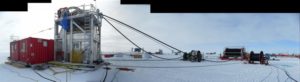
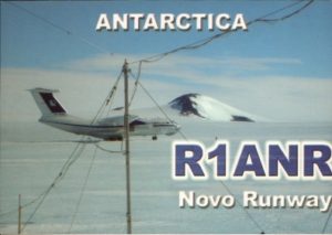
Making an HF contact into Antarctica is always a great DX!  One of the very active spot on the Icy Continent is the Blue one Runway (or Novo Runway aka DROMLAN), an Airbase managed by ALCI (Antarctic Logistics Centre International) that works during the austral summer from late October to beginning of March, as a logistics service provider in the Dronning Maud Land Air Network (DROMLAN) since its inception in 2002. It offers a full range of services for the flights from Cape Town to Antarctica.

These include chartering suitable aircraft and helicopters when necessary, additional equipment for aircraft with required safety and rescue equipment, providing all necessary permits, licenses and insurance for this type of flight, handling of crew, passengers and cargo at Cape Town airport, supply of aviation fuel in Cape Town and Antarctica. ALCI make sure that both aircraft and crew comply with all International standards on safety and operations and that aviation activity in Antarctica will not be detrimental to the environment.

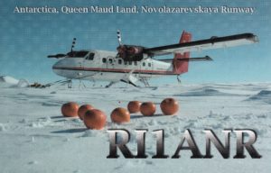
In this very important site,  Ham radio activity has never been left out. Three unforgettable operators; OlegSakharov ZS1ANF,  Slava Savkin RD3MX and  Alex Shmarin  UA1PAW  have been active from Novo Runway  (70° 49’ 31” South, 11° 37’ 41” East) since 2007 giving thousands of Hams a real new one or a great DX, tying up  their callsigns to the history of Radio communication from the Antarctic.


Thanks to Nick Shapkin RK1PWA, we have just received the last printed QSL of RI1ANR that confirms the QSOs of 2015-2016

Annual Event from Antarctica at Base Marambio (WAP ARG-21)

LU4ZS, Marambio Antarctic Base Station (WAP ARG-21), operated by Cristian LU4CMF, will be on air from July 7 to July 15 in SSB and FT8 modes. Cristian will also join the participation in the annual event “The Argentine Republic in two days” this  weekend,and it  will be managed by LU4AA, foreseeing an operation in 7 MHz band,  SSB mode.
The contacts of this operation will be confirmed via LU4AA.

Facebook, Twitter and WhatsApp social  will provide the followers with  news and information

Here below, a more than shareable comment by Juan Manuel Pereda LU4CJM, aka operator at LU1ZI Carlini Station and to few of the very rare Argentine Refuges in Antarctica

Amateurs, media and institutions related to the radio around the world,  contact me asking when LU1ZI Argentine Antarctic Base “Carlini” (WAP ARG-20),  one of the “Most wanted contacts” at international level will be airing again.

How to explain to all these people that the “change of authorities”, the “lack of investments in equipments” and the ”lack of interest in the Ham radio activity” made the Argentine Scientific Bases in Antarctica disappearing from the Ham radio field?

Luckily there are people who carry on huge efforts to continue the activations from the white continent. Congratulations to the Marambio Base and to the Argentine Radio Club LU4AA for persisting to spread Argentine Antarctic Ham radio activity around the world.

Felicitaciones a la Base Marambio y al Radio Club Argentino por seguir difundiendo la actividad Antártica Argentina alrededor del mundo.

TNX LU4ZS, LU4CMF, LU4AA & LU4CJM

I have been to Antarctica

Today news, is dedicated to the over 7,000 members of  “I have been to Antarctica”, a Facebook group devoted to all those who have been to the Icy Continent, who did travel or want to travel to the icy edge of the Earth and made it back to share their stories.

The site is hosted on the page of Facebook:  (https://www.facebook.com/groups/2212798205/?ref=bookmarks) ; Tim Baker (Administrator) says: -This is a place to post about things that happen/happened on/around the ice, or a place for people to ask questions about it-.

Not only penguins or marine life; Antarctica is a land of study and research with several Scientific Bases all spread on the coast, on the islands and inside the main land … a land of peace and fraternity, that’s why it’s a great Continent!  WAP is happy to share the Antarctic passion with those, like us, who enjoy Antarctica as much as we do since 1979 …and next year, will be our 40th Anniversary!!!

Elephant Island- Emilio Goeldi Refuge WAP BRA-Ø5

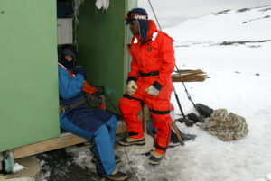
Refuge Emílio Goeldi  (WAP BRA-Ø5) is a Brazilian Antarctic summer facility on Elephant Island . It was named after the Swiss-Brazilian naturalist and zoologist Emil Goeldi. The structure, built in 1988, can accommodate up to 6 scientists for up to 40 days  and depends both logistically and administratively on Comandante Ferraz Station station  (WAP BRA-Ø2).

Elephant Island is an ice-covered, mountainous island off the coast of Antarctica in the outer reaches of the South Shetland. Its name was given by early explorers sighting elephant seals on its shores. It lies 779 miles west-southwest of South Georgia, 581 miles south of the Falkland Islands, and 550 miles southeast of Cape Horn. It is within the Antarctic claims of Argentina, Chile and the UK.

Elephant Island contains the Endurance Memorial Site, an Antarctic Historic Site (HSM 53), with a bronze bust of Capt Luis Pardo (see pic aside), who rescued the 22 remaining survivors from Earnest Shackleton’s and several plaques.

Hampson Cove on the south-west coast of the island, including the foreshore and intertidal area, contains the wreckage of a large wooden sailing vessel; it has been designated a Hitorical Site or Monument (HSM 74), following a proposal by the United Kingdom to theAntarctic Treaty Consultattive Meeting.


As far as we know, Emilio Goeldi Refuge (WAP BRA-Ø5) was only activated once, in 2004 by ZXØECF and ZXØGTI as documented  by the pic on the side.

WAP reference BRA-Ø5  was given to the Refuge,  after receiving the documentation from the kind operators:  Roberto Stuckert (PT2GTI/ZXØGTI) and Jorge Luiz Lunkes (PT2HF/ZXØECF)

Martel Inlet Lighthouse, WAP BRA-LH ØØ1

Located at 62° 5’ South, 58° 22’ West, Martel is an inlet forming the northeast head of Admiralty Bay on King George island, in the South Shetlands Islands, off Antarctica. It was charted in December 1909 by the Fourth French Antarctic Expedition under Jean Baptiste Charcot and named “Fiord Martel” after J.L. Martel, a French politician.


The square pyramidal skeletal metal tower with balcony and light of Martel Inlet Light House  (WAP BRA-LH ØØ1),  was constructed on a concrete basement in the year 2007 and   lies exactly at 62° Ø5’ Ø2” South, 58° 23’ 31” West.  Its markings / pattern is  red and white tower, red lantern  with a Focal height of 14 metres (46 ft),  with a Range of 10 nautical miles (19 km; 12 mi). Light is sourced by solar power . It is administered by the Brazilian Comandante Ferraz Research Base (WAP BRA-Ø2)


Martel Inlet Light House  has the Admiralty  number G 1387.5,  NGA number 2729, WAP Reference for  LH in Antarctica & Peri-Antarctic areas  WAP BRA-LH ØØ1.

It was first activated in 1985 by ZXØECF.
Lighthouses
in Antarctica and Peri-Antarctic areas are recently been included in the new  “WAP LH Award” among WAP-WACA & WAP-WADA, the two main Antarctic Awards.

Grytviken station, (WAP GBR-29) South Georgia Island

Even in the most distant corners of the world, the ruins of man’s industry are abundant. One of the most haunting locations is the abandoned settlement of Grytviken, a forgotten whaling station founded in 1904 by Norwegian sea captain Carl Anton Larsen. Serviced by 300 men during its heyday, the productive station took 195 whales during its first season alone, spearheading a highly profitable trade that saw every part of the animal, from blubber to meat to bones, put to use.

This is raw drone footage of the shore whaling, including the British Antarctic Survey Base (WAP GBR-29), graveyard and Hydro Dam.

Footage was recorded with a DJI Mavic Air in April 2018, recorded by Geometria Ltd. for the Government of South Georgia and the South Sandwich Islands. All flights were operated under permit from GSGSSI.

Thanks and credit to: Daniel McCurdy

Today, Grytviken is a haunting ghost town on the shores of King Edward Cove, a collection of decaying buildings, vintage oil tanks, silent processing plants and abandoned whaling ships. Far beyond the reaches of vandals, it remains frozen in time. The South Georgia Museum, accessible to cruise ship tourists, is located within the former house of the whaling facility manager and his family.
See more at: https://www.urbanghostsmedia.com/2013/10/abandoned-whaling-station-grytviken-south-georgia-photos/ 

On the Ham radio wise, Grytviken Station (WAP GBR-29) was last activated  on 2007 by VP8DJV & VP8DKG, while the 1st station reported active  from Grytviken Station was VP8BK on 1956.

NSF invites professional news media to submit proposals to report from Antarctica

The National Science Foundation (NSF) is accepting proposals from media professionals to visit Antarctica to report on research supported by NSF’s Office of Polar Programs (OPP) through the U.S. Antarctic Program (USAP).

Those selected to deploy would visit Antarctica between early November and mid-December of 2018.

Applicants must submit to NSF a written expression of interest in participating in the program — the equivalent of no more than three printed pages — describing the media in which the reporting will appear and a description of the potential audiences.  For reporting unrelated to the Thwaites Glacier opportunity, U.S. media receive preference in selection.

Application deadline: 5 p.m. (local time) on July 15, 2018. Electronic submissions are required, either as an email or as an attachment to an email. The email subject line must read “2018 Antarctic Media Application” or the application will not be considered.

More details at: https://www.nsf.gov/news/news_summ.jsp?cntn_id=295843&WT.mc_id=USNSF_51&WT.mc_ev=click

Antarctica contaminated with microplastics

Microplastics and chemicals used in a range of household goods have found their way to Antarctica’s pristine waters and ice caps, research shows.
Greenpeace says the microplastics, which are commonly used in body washes and toothpaste, and polyfluorinated alkylated substances (PFAS), like those used in non-stick cookware, were found in samples taken from Antarctica’s waters and snow between January and March this year.
The findings have sparked calls from Greenpeace for an Antarctic ocean sanctuary to be set up, so penguins, whales and the frozen continent’s entire ecosystem can recover from the pollution pressures they are facing.
“We may think of the Antarctic as a remote and pristine wilderness, but from pollution and climate change to industrial krill fishing, humanity’s footprint is clear,” Greenpeace’s Protect the Antarctic campaign spokeswoman Frida Bengtsson said as the findings were released on Thursday.
“Plastic has now been found in all corners of our oceans, from the Antarctic to the Arctic and at the deepest point of the ocean, the Mariana Trench. We need urgent action to reduce the flow of plastic into our seas.”
The microplastics and potentially hazardous chemicals were detected in samples collected from the sea surface and seabed, as well as freshly fallen snow in remote waters and islands off the Antarctic Peninsula and Bransfield Strait.
Microplastics, which include synthetic fibres and beads found in personal hygiene products, were found in seven of the eight water samples, with at least one microplastic fibre per litre.
They were also detected in another two samples collected using a manta trawl net that scraped along the sea surface.
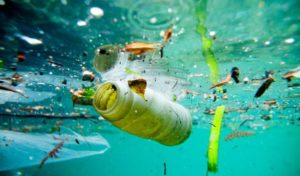
There is growing concern internationally about the increasing presence of polluting microplastics in waterways, with many countries having banned their use in cosmetic products.
While the United States has banned microbeads, which can be mistaken by sea animals as food, Australia is relying on companies to voluntarily phase them out by the middle of this year.
Greenpeace said while not much was known about the extent of microplastics in Antarctica, its research suggested that the continent’s natural barrier to seawater flowing from the north – the Antarctica circumpolar current – was being breached by the tiny polluting particles.
As part of Greenpeace’s research, traces of PFAS, which are used in non-stick cookware, waterproof clothing and fabrics, and fire-fighting foam, were found in seven of nine fresh snow samples that were collected and analysed.
“The findings in snow samples are unlikely to be due to contamination from local inputs as a result of research activities and tourism in the local areas, as the snow was freshly fallen,” Greenpeace said in a report.
“The chemicals found in the snow could have been transported in the atmosphere over long distances, washed out by precipitation and then deposited in the Antarctic snow.”
Source: https://www.theaustralian.com.au/news/latest-news/antarctica-contaminated-with-microplastics/news-story/eb6a8d6453ca2577da40b12ba8f56eed

Activation of VI7ØMI WAP-293

VI7ØMI is a Special Callsign issued to Commemorate 70 years of  ANARE (Australian National Antarctic Research Expeditions) for Macquarie Island, which since 1947 have served Australia in the South polar regions. The first ANARE Expedition to Macquarie Island was in March 1947.

A Special Event Callsign VI7ØMI (Both Zone 29 and Zone 30 will be using this call) will be active from June 20th until August 31st 2018.
All HF bands 160m-10m, SSB, CW, RTTY and possibly digital modes also.

VI7ØMI will be joining the WAP World Antarctic Program and the WAP reference given is  WAP-293.  (For further info on WAP, see: http://www.waponline.it)
*** Please Note: This Commemorative activity is from mainland Australia and NOT from Macquarie Island. ***

Back to the history:
In 1912, Australia pioneered the first radio communications in Antarctica at the Commonwealth Bay base via a relay station at sub-Antarctic Macquarie Island. Australia established its first stations in the sub-antarctic at Heard Island in December 1947 and Macquarie Island a few months later in March 1948.
The sub-Antarctic station on Macquarie Island was officially opened on 21 March 1948, with a team of 14 expeditioners staying for winter. For the first time, expeditioners were not cut off from the world; instead receiving regular news, and sending official and personal messages back home. Wintering Party on Macquarie Island in 1948 :
Officer in Charge : Alan R Martin
Medical Officer : A Roger Bennett
Cook : Charles F (Charlie) Du Toit
Diesel Mechanic : Charles H Scoble accidentally drowned 4 July 1948
Diesel Mechanic : T Frank Keating from 4 Aug 48. landed from RAAF Catalina flown by S/L R H S Gray
Radio Supervisor : Geoff Mottershead
**Radio Operator: Peter W King
**Radio Operator: Gersh Major

Biologist : Ron Kenny
Meteorologist : Alan R Martin
Weather Observer : William M (Bill) Monkhouse
Weather Observer : Ron M Chadder
Physicist : Ken C Hines
Physicist : Charles S (Charlie) Speedy
Photographer, Department of Information) : Norman R (Norm) Laird
The station was commissioned on 21 March 1948 after Wyatt Earp had arrived at Buckles Bay. The first ANARE wintering party comprised 13 expeditioners. On 4 August 1948 an RAAF Catalina flying boat piloted by R H S Gray visited the Island to put ashore a diesel mechanic to replace Charles H Scoble who was accidently drowned a month before. The Catalina returned to Wigram, New Zealand the same day with mail. Sheep and goats were introduced and comprehensive long term scientific programs were initiated. (Information above collected by Max Corry)

To date there has never been a Ham Radio DXpedition to Macquarie Island. The only activities are from Hams stationed on the island for Summer or Winter tours.
Currently Norbert VKØAI is the only active operator on Macquarie Island (WAP AUS-Ø8)

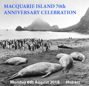
The Special event callsign VI7ØMI (WAP-293) is to commemorate the 70th Anniversary of the establishment of the first ANARE base at Macquarie Island, March 1948. The activity is to raise the profile of the Wireless Institute of Australia (WIA), Amateur Radio in general, ANARE, Parks Tasmania and the Antarctic Research programs globally and within Australia.
A special commemorative QSL card will be available after completion of the activation via MØOXO our QSL manager. https://www.m0oxo.com/oqrs/logsearch.php

QRS will be available and also LOTW.
*** Please do not send your QSL cards via the VK buro as they are not required – Please just request your buro cards by OQRS for a fast return! ***

Interesting and useful links:
http://www.antarctica.gov.au/living-and-working/stations/macquarie-island
http://www.antarctica.gov.au/webcams/macquarie-island
https://en.wikipedia.org/wiki/Macquarie_Island_Station
http://www.parks.tas.gov.au/fahan_mi_shipwrecks/journals/Scientists/sowirelesscrew4.pdf
http://www.antarctica.gov.au/about-antarctica/history/exploration-and-expeditions/anare-is-created
http://anareclub.org/web/index.php
http://wia.org.au/

TNX Malcolm Johnson VK6LC &  Peter Clee VK8ZZ

K1IED, Larry F Skilton, is SK

Larry did a long time service for the stations in Antarctica; years ago Larry was very active in the 14.240 DX Group to keep contact with the operators down in the Icy Continent and also acting as official  QSL manager for KC4USV, McMurdo (WAP USA-22),  KC4AAA Amundsen-Scott South Pole Station (old WAP USA-21 and most recent rebuild WAP USA-36), and KC4AAC, Palmer Station (WAP USA-23).

Larry K1IED is SK as of June 2, 2018; he was a great guy. He had been battling cancer for some time and it got the better of him recently.

We don’t know who might try now  to take over the  Antarctic QSL duties, but sure someone from the US will do that.

We will miss you Larry, R.I.P.

Adelaide & Rothera Stations (WAP GBR-13 & WAP GBR-12)

It was not until the British Graham Land Expedition of 1934–37 that Adelaide was confirmed to be an island separate from the Antarctic Peninsula. The Research Base at Adelaide Island   referred to as Adelaide Base “T”  (WAP- GBR-13) from July 1962,  was established on 3 February 1961 on the South-West tip of the island. This was in preference to Rothera Point as it had a better skyway for aircraft and less sea ice to hinder access by ship. It was closed when the skyway deteriorated and operations were transferred to Rothera Station.


Taken middle to late April 1976, showing the change from the summer weather to the winter,rain to snow and winds. Note the steps up to the front door of the base in the rain and then the snow steps up out of the base after the snow and blizzard.This was the last winter at Adelaide base before moving round to.

Rothera Station (Station “R”), 67° 34′ South, 68° 08′ West,   (WAP GBR-12) known as Rothera Point until 15 August 1977, was established in 1975 to replace Adelaide, where the glacier ski-way had deteriorated rendering the operation of ski-equipped aircraft hazardous.

A party  did camp at Rothera Point in the 1975/76 austral summer to open up the air facility.

There was a phased construction programme so that by 1980 the station provided accommodation, electrical power generation, vehicle workshops, scientific offices and a store for travel equipment.

Enjoy a drone tour of Rothera Station WAP GBR-12  at the video shown below

Polar 2018-Davos Switzerland 15-26 June 2018


The WSL Insitute for snow and Avalance Research SLF is organizing POLAR2018,  which will take place in Davos, Switzerland from 15 – 26 June 2018.

Where the Polar comes together
POLAR2018
is a joint event from the Scientific Committee on Antarctic Research SCAR and the International Arctic Science Committee IASC.

The SCAR meetings, the ASSW and the Open Science Conference will be hosted by the Swiss Federal Institute for Forest, Snow and Landscape Research WSL under the patronage of the SAwiss Committee on Polar and High Altitude. The event, will include:

XXXV SCAR Biennial Meetings

Arctic Science Summit Week 2018 & IASC Business Meetings

SCAR/IASC Open Science Conference

2018 Arctic Observing Summit

Timeline
15 – 18 June 2018 SCAR and IASC/ASSW Business & Satellite Meetings

19 – 23 June 2018 SCAR/IASC Open Science Conference & Open COMNAP Session

24 – 26 June 2018 SCAR Delegates Meeting & 2018 Arctic Observing Summit

Read more and follow the program at: https://www.polar2018.org/

Refuge General Jorge Boonen Rivera (former General Ramon Cañas Montalva) WAP CHL-NEW

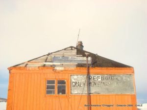
View Point was the location of the British research Station “V”. It was active intermittently with the intention of searching in the survey, meteorology and geology. Located on Duse Bay, Trinity Peninsula, at 63° 32′ 15″ South 57° 24′ 15″ West,  the site was selected on 8 Feb 1953, foundations of first hut laid 3 June 1953. A second hut was erected on 20 Mar 1956 and called Seal-catcher’s Arms or View Point Hut ,
Station “V” was erected as a satellite base for  Hope Bay Station  “D”  WAP GBR-Ø4 (ceded to Uruguay in 1997 which renamed it  Base Lieutenant Ruperto Elichiribehety  WAP URY-NEW).

On July 29, 1996 the Station “V”  was transferred to Chile who renamed it General Ramon Cañas Montalva. Today Refuge General Jorge Boonen Rivera (former General Ramón Cañas Montalva) is a small Chilean Antarctic refuge, administered by the Army of Chile.

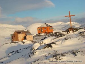
The refuge consists of a cabin enabled as a room and a second machine house, bathroom and storage. It is located about 50 km away from the Chilean base General Bernardo O’Higgins (WAP CHL-Ø2), on which it depends.


Currently the installation is regularly maintained by Chile, for use as an emergency shelter, allowing 8 people to survive in it for 20 days in the event of an accident. For this purpose, the station has an electric generator, as well as fuel, food, water and gas.

For full listing of all station histories, see: History of British stations and refuges.

https://www.bas.ac.uk/wp-content/uploads/2015/03/British-Antarctic-Stations-Refuges-v6.2-2016.pdf

Prathyusha inspires many towards Antarctica dream

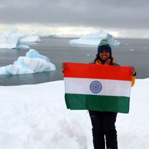
Prathyusha Parakala is the only one from AP and TS to be part of the ClimateForce: Antarctica (CFA) expedition 2018.

HYDERABAD: Scores of Hyderabadis are making the city proud by trekking to Antarctica. Prathyusha Parakala is the latest trailblazer from the city, who was among the 90 global climate force ambassadors selected to create awareness about climate change.
“Until last year, there were spots in Antarctica where humans could not reach as it was covered with thick ice. This year, we could do so. This was after climate change, which led to melting of ice,” said Parakala, who was felicitated for her achievement by Telangana chief minister K. Chandrasekhar Rao with the ‘Visisht Puraskar’ on Formation Day.
Parakala is not the only one to have made it to the group of  ambassadors. Apart from this, city-based entrepreneur and engineer Vijay Raghav Varada was also selected to fly to Antarctica to evaluate performance of his innovation, a 3D printable vertical wind turbine that generates energy.
In 2016, Thammala Sandhya, a mother of two, was among many explorers from across the world to be a part of the International Antarctic Expedition. In January 2018, doing away with a comfortable job in an e-commerce firm, Sunil Kumar, a city-based chartered accountant took part in the expedition

This was the last year that the two-week expedition to Antarctica was hosted by reputed environmentalist Robert Swan.

Source: https://timesofindia.indiatimes.com/city/hyderabad/prathyusha-inspires-many-towards-antarctica-dream/articleshow/64501307.cms
TNX: 
Bhagwati Prasad Semwal (VU3BPZ Ex-AT10BP/8T2BH)
(20,24,29,31,35th, WOT Maitri/Bharati )

ITALIA Valley Memorial, a job to be proud

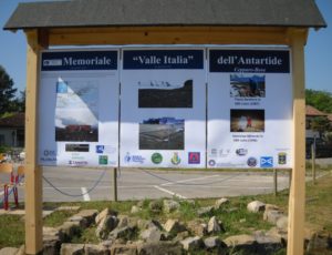
The tireless PH D Julius Fabbri IV3CCT did accomplish the mission to build a Memorial to recall the Giacomo Bove Base (WAP ITA-Ø2) in Antarctica and the 1st Italian Antarctic Expedition (Antarctic summer 1975-1976) led by Renato Cepparo, I1SR, with the aim of bringing Italy into the group of states adhering to the Antarctic Treaty.


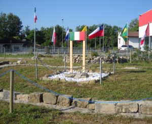
Following the laying of the foundation stone on February 24th 2018, last May 25 when the job was done,  a nice  ceremony was held at the “A. Malignani” High School of Cervignano (Udine); the inauguration of the Memorial, with Authorities and Students was a great moment of satisfaction even for the young students, Professors and all those who did help the construction of this Memorial which now a reality to be proud.

Malignani School will also be the location for the 2019  WAP Antarctic Activity Week,  on the air with the special call  II3BOVE WAP-271.

TNX IV3CCT & IV3RYQ

US Yesterday Field Camp, WAP USA-44

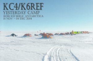
WAP and the Ham’s Antarctic Community are grateful to Dr. Ron E. Flick K6REF, for the New WAP Reference, USA-44 issued after his activity from the US  Yesterday Camp.

Here is a brief story told by Ron, K6REF, when he did come back home after his season in Antarctica.

Returned from Antarctica on schedule tired and sore (with wrist problems that should resolve) after many hours of flying! We deployed over 30 seismometers over the Ross Ice Shelf to measure ocean swell-induced vibrations, and to determine the structural properties of this largest ice shelf in the world. Ham radio was part of the public outreach for this National Science Foundation (NSF) sponsored project.

I was able to operate from the McMurdo Ham shack (KC4USV,  WAP USA-21) with about 450 contacts between 5 and 13 Nov 2014. We spent that time there training and getting equipment ready, and waiting for weather suitable to fly to the field camp.


On 15 Nov 2014 we departed McMurdo in an LC130 from Willy Field and arrived at Yesterday Camp (78° 57.35 South by 179° 53.19 West) located near the Dateline in the middle of the Ross Ice Shelf (RIS), which is the size of France.

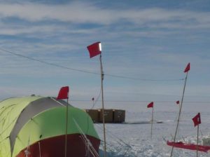
We camped at Yesterday Camp in amazingly cozy mountain tents for 19 days. We had several larger heated work and eating tents as well, and after a few days the cold didn’t seem so bad! The temperature was about -25°C (-13°F) when we arrived, gradually warming to a balmy -10°C (+14°F) by the time we left. We drank some beer outside once during a cold snap, and by the time I got half my can empty the rest was turning into frozen slush!

I operated from Yesterday Camp as KC4/K6REF between 18 Nov and 3 Dec 2014, making about 150 contacts in 27 countries and 23 US states. I used my Yaesu FT847 barefoot with a simple wire dipole mounted on flag poles about 8 feet off the ice. Conditions were often frustrating with one-way in propagation. I spent almost an hour trying to reach TY2CD in Benin (where there are only two licensed amateurs), all the while hearing Wynand at 58, but with him utterly unable to hear me. There were a few pileups, especially from European stations eager to log a once-only Antarctica contact. Picture above show the science tent QTH shack with diplole antenna on flag poles.

Thanks for all the QSOs, and apologies if you could not get through! I’m especially grateful to Bill K7MT and Bob K4MZU for their relay help and general support, and to Bob KK4KT and Roy KR6RG for their perserverance  and the timeless (old fashioned) phone patch to my wife Myra (boy, was she surprised!). Also thanks to Joe AB6RM for posting a publicity piece in QST and to many other hams who spotted KC4/K6REF on the DX sites!

TNX K6REF

QSLs  for KC4/KC6REF (Yesterday Camp WAP USA-44) have to be requested  to:

REINHARD E FLICK, K6REF,  10764 LOIRE AVE, SAN DIEGO, CA 92131. USA

For more information on the science see: https://scripps.ucsd.edu/centers/iceshelfvibes/taking-the-pulse  and the pages linked from there .


Albatros Refuge (WAP ARG-27)

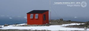
Antarctic shelters are facilities open to all countries, to be used in cases of emergency or to support activities in the field. They are equipped with food, fuel (there are with generators and communication equipment), accommodation facilities and other logistics. On  King George Island (aka Isla 25 de Mayo), just to the South of Argentine Base Carlini ,WAP ARG-20 (ex Jubany Base) on Potter Peninsula  there is a Special Protected Area  (ASPA 132) which extends from Potter cove to Stranger point.

Outside the zone, there is a small shelter, called Albatros, on the cliff which looks towards the coastline, about 50 meters high from the beach and less than 1 Kilometer from the Elephant shelter, in the E-SE direction.

Ham radio activity from Albatros Refuge (pic above, WAP ARG-27) have been performed recently for a very short time on March 2016 by LU4AA/Z operated by Juan Manuel Pereda LU4CJM  (see pic aside).

The Albatros Refuge (WAP ARG-27) depends on Carlini Base (WAP ARG-2Ø ) and is located on the Potter Peninsula at  62 ° 15’09 South,  58 ° 39’23 West,  3 km from the Base, about 100 m above sea level.

The refuge houses a repeater of analogue / digital VHF of the latest technology powered by solar energy that provides telecommunications support from radio frequency to all the scientific and logistical personnel in the


field, allowing the geo-location of them in real time and a coverage of more than 35 kilometers.


Another Refuge nearby is Elephant Hut (pic to the left);  it is located about 1000 mts from Punta Stranger, in the northwest direction. It is usually used by research groups as a resting point. The shelter occupies an area of about 25 square meters and has capacity for two people. Elephant refuge still remains a brand “New One”!

TNX LU4CJM/LU1ZI

Svea (WAP SVE-Ø2) & Wasa (WAP SVE-Ø4) Antarctic Swedish Stations

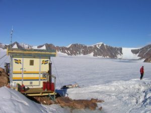
Svea is located in the Scharffenbergbotnen valley in the Heimefrontfjella mountain range, about 400 km from the coast. It was built during the 1987/88 Antarctic expedition and was the first Swedish research station in Antarctica since the Snow Hill station in 1901 and Maudheim in 1949.

Svea (WAP SVE-Ø2) pic to the left is a satellite station to Wasa  (WAP SVE-Ø4) pic to the right and is an excellent Base for small, transient research teams performing fieldwork in the area. The station, comprising two joined fibreglass modules, is about 12 m2 and has four beds and one pantry.

The Station is currently the home base for two permanent monitoring projects: continual geodetic measurement using GPS technology, run by the Royal Institute of Technology in Stockholm, and a seismograph that records movements in the earth’s crust, run by the German Alfred Wegener Institute.

Japan in Antarctica: Sixty Years of Antarctic Research

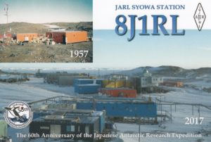
The story of Japan’s involvement in the Antarctic goes back to 1955, when it announced at a special committee on the International Geophysical Year in Brussels that it planned to begin research in the region.


On November 8, 1956, Japan’s first Antarctic research ship “Soya”  departed from Harumi Terminal of Tokyo port, carrying the first Japanese  Antarctic Research Expedition (JARE) Team, consisting of fifty-three members.

Seventeen members of the Team landed on Ongul Islands. They selected the  place for the Main base for their expedition and named it “Syowa Station”.

Since then, scientific research have been carried out for more than sixty  years involving about 3,400 members so far.


On January 29, 2017, the Japanese research Base “Syōwa Station”  (WAP JPN-Ø3) did celebrate 60 years since its opening.
A sixtieth birthday is a landmark date in the life of any person or institution. Over the course of those six decades, Japan has steadily carried out scientific research in Antarctica, publishing numerous results. These include many new discoveries that no one could have predicted when work began in Antarctica, as well as a number of important clues for predicting the future of the global environment.


2017 did mark this important anniversary! Thanks to Yath Yoshikawa (JG2MLI)  the official station 8J1RL was again on the air  from Jan.1-2017 through Jan.20-2018 at SYOWA Station (WAP JPN-Ø3).

In addition to 8J1RL Yath did operate also with the special callsign “8J6ØJARE“. After a year in Antarctica, now Yath is back home and we just got the QSLs for the contacts made.

Great job Yath, thanks a lot!

TNX: JG2MLI/8J1RL-8J6ØJARE


Read more at: https://www.nippon.com/en/currents/d00249/

Nanda Devi Hut, Antarctica (WAP IND-NEW)

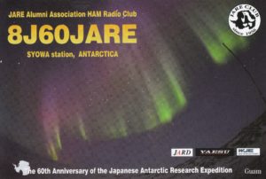
Nanda Devi Hut is a summer shelter in the area of the Indian Maitri Base (WAP IND-Ø3).

Hut name comes from are Nanda Devi in Himalaya mountain, the second highest mountain in India, and the highest located entirely within the Country.

An old photo (1989/90) shows the Hut that was in use before the build of Maitri Station (WAP IND-Ø3).
It was erected by the construction Team, which came from Daskshin Gangotri Station (WAP IND-Ø1) by helicopter & staying in that hut for rest.

TNX Bhagwati VU3BPZ (aka AT1Ø0BP, 8T2BH)